25th Annual Black Diamond Fall Fundraising Party
Thursday, September 13; 6:00-10:00 PM; Black Diamond Parking Lot
25th Annual Black Diamond Fall Fundraising Party
Thursday, September 13; 6:00-10:00 PM; Black Diamond Parking Lot
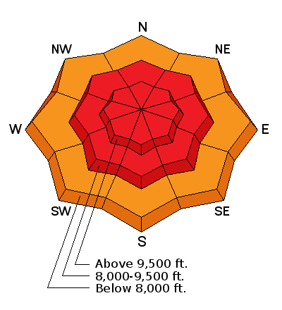
| Advisory: Provo Area Mountains | Issued by Evelyn Lees for Friday - December 16, 2016 - 7:18am |
|---|

|
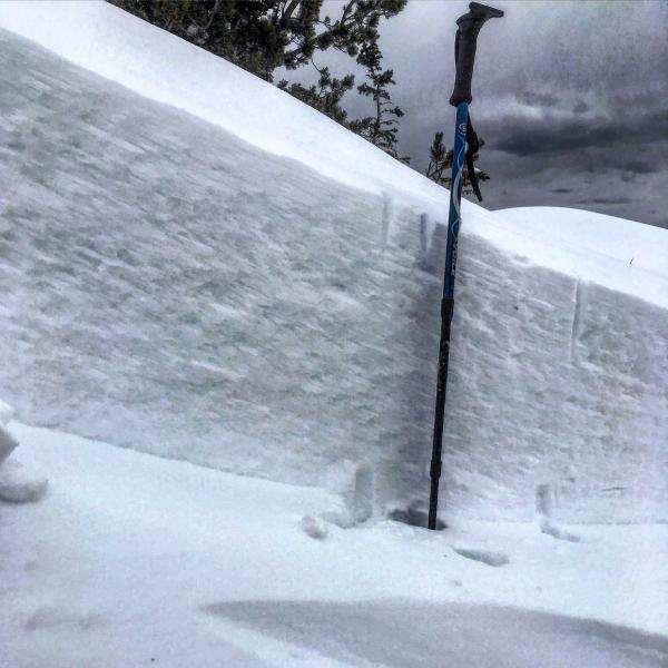
bottom line An Avalanche Warning has been issued for the Salt Lake and Park City area mountains. Strong winds, heavy snow and rain have created a HIGH AVALANCHE DANGER at the mid and upper elevations. A CONSIDERABLE DANGER exists at the low elevations where wet sluffs can be triggered in the rain soaked snow. Stay off of and out from under slopes steeper than 30 degrees, including small terrain features such as gullies, creek beds, roofs and road banks. If you want to ride the steep slopes, head to one of our world class resorts today.
|
 |
avalanche warning THE FOREST SERVICE UTAH AVALANCHE CENTER IN SALT LAKE CITY HAS ISSUED A BACKCOUNTRY AVALANCHE WARNING…FOR THE MOUNTAINS OF NORTHERN AND CENTRAL UTAH INCLUDING THE WASATCH RANGE...BEAR RIVER RANGE...WESTERN UINTA...AND MANTI SKYLINE MOUNTAINS. THE AVALANCHE DANGER FOR THE WARNING AREA IS HIGH AND WILL REMAIN HIGH THROUGH SATURDAY. HEAVY SNOW, MOUNTAIN RAIN AND STRONG WINDS HAVE CREATED WIDESPREAD AREAS OF UNSTABLE SNOW AT LOW, MID AND UPPER ELEVATIONS. BOTH HUMAN TRIGGERED AND NATURAL AVALANCHES ARE VERY LIKELY. STAY OFF OF AND OUT FROM UNDER SLOPES STEEPER THAN 30 DEGREES AND AVOID AVALANCHE RUNOUT ZONES. |
 |
special announcement Little Cottonwood Canyon Backcounrty Closure is in effect for the terrain on the North side of the canyon from Lisa Falls through Little Superior all day. Terrain South of White Pine Trailhead and North side terrain from Cardiff peak up to Grizzly Gulch is open. This closure will probably last through tomorrow morning at 0800, with a full North side canyon closure expected tonight. Deer Valley will be doing explosive work tomorrow, so please stay out of Empire and Lady Morgan areas. Thank you. Discount lift tickets for Alta, Snowbird, Brighton, Solitude, Sundance, Snowbasin, Powder Mountain, and Beaver Mountain are now available, donated by the resorts to benefit the Utah Avalanche Center. Details and order information here. These make a great holiday gift and all proceeds go towards paying for avalanche forecasting and education! |
 |
current conditions A strong, moist southwest flow will keep snow levels high today ahead of the afternoon cold front. Overnight, the Provo area mountains received very impressive amounts of water, in the form of rain and.\/or snow. The rain/snow line vacillated between 7,000 and 8,000 feet. Aspen Grove: 1.5" of snow, 3.6" of water (mostly rain) Bunnels (8800') : 9" of snow, 1.9" water in that snow Sundance (7500') : 6" snow, 2" water in that snow Currently, heavy snow is falling at the upper elevations in the mountains, especially in areas favored by southwest flownew at, while rain continues to fall at the lower elevations. The southwesterly winds have been moderate to strong for over 24 hours, averaging 20 to 30 mph, with the high ridge lines reaching 40 mph averages, gusting in the 60s. |
 |
recent activity No new observations from the Provo area mountains. Yesterday’s backcountry avalanche activity in the Salt Lake/Park City mountains included 2 natural hard slab avalanches in West Monitor, triggered by natural cornice fall. These were about 50’ wide, running full track. Ski cuts and explosives at resorts released soft and hard slabs up to 2 feet deep, with the slabs becoming larger and more connected as the day went on. Mark White photos - West Monitor
|
| type | aspect/elevation | characteristics |
|---|

|
|
LIKELIHOOD
 LIKELY
UNLIKELY
SIZE
 LARGE
SMALL
TREND
 INCREASING DANGER
SAME
DECREASING DANGER
|
|
description
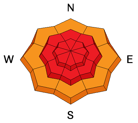
Long duration, strong southwesterly winds have blown the snow into hard slabs, soft slabs and cornices, both along the ridge lines and down onto mid slopes, at both the upper and mid elevations. Hard slabs are stubborn and dangerous – they let you get out mid-slope before breaking above you. The hard cornices will break back further than expected today – pulling up onto the “flats” of the ridge lines. Out of the wind affected zones, new snow slides can be triggered on steep slopes. |
| type | aspect/elevation | characteristics |
|---|

|
|
LIKELIHOOD
LIKELY
UNLIKELY
SIZE
 LARGE
SMALL
TREND
INCREASING DANGER
SAME
DECREASING DANGER
|
|
description
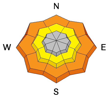
Wet avalanches are unusual in December, but we’ve got them today. At and below the rain/snow line, it will be possible to trigger wet sluffs in rain soaked snow. Even a small wet slide can pile up deep, cement like debris in terrain traps, such as gullies, creek beds and below road banks. Any snow remaining on steep roofs could slide today. |
| type | aspect/elevation | characteristics |
|---|

|
|
LIKELIHOOD
 LIKELY
UNLIKELY
SIZE
LARGE
SMALL
TREND
INCREASING DANGER
SAME
DECREASING DANGER
|
|
description
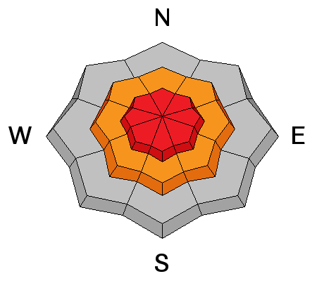
There are multiple layers of weak facets in our snowpack – near the ground on upper elevation, northerly facing slopes, mid pack on all aspects and just below Wednesday’s recent snow. Today, slides could break into any of these weak layers, producing deep, wide slab avalanches. |
 |
weather The moist southwest flow will continue into the afternoon, with periods of heavy snow adding another foot of snow to the storm totals. The southwesterly winds ahead of the front will increase once again ahead of the front, averaging 30 mph, with gusts along the high ridge lines reaching into the 80s. The cold front should arrive by mid afternoon, with a chance of thunder and lightning. Temperatures will plummet behind the front, dropping snow levels to the valley floor. Areas favored by northwest flow could get an additional 3 to 6” of snow tonight, and lows will be near zero. |
general announcements
|


 This information does not apply to developed ski areas or highways where avalanche control is normally done. This advisory is from the U.S.D.A. Forest Service, which is solely responsible for its content. This advisory describes general avalanche conditions and local variations always exist.