25th Annual Black Diamond Fall Fundraising Party
Thursday, September 13; 6:00-10:00 PM; Black Diamond Parking Lot
25th Annual Black Diamond Fall Fundraising Party
Thursday, September 13; 6:00-10:00 PM; Black Diamond Parking Lot
| Advisory: Ogden Area Mountains | Issued by Paige Pagnucco for Friday - March 30, 2018 - 6:15am |
|---|

|
bottom line The avalanche danger is generally LOW. Low danger does not mean no danger. There is still a chance you could trigger a small wind slab avalanche in steep upper elevation exposed terrain. Also, avoid the steep sunny aspects by midday and afternoon as they may become wet and unstable.
|
 |
special announcement The newest issue of the Powder Cloud, the newsletter of the Utah Avalanche Center is hot off the presses. You can always grab a cup of coffee and while away the time by looking at new and old issues of the Powder Cloud, other essays, and blogs. Look for them in the menu above or click here.
The UAC Marketplace is still open. Our online marketplace still has deals on skis, packs, airbag packs, beacons, snowshoes, soft goods and much more. We have lift tickets for Snowbasin and Powder Mountain remaining. The tickets are discounted an additional 20%. Details and order information here. All proceeds from these go towards paying for avalanche forecasting and education! |
 |
current conditions Mountain temperatures in the upper 20s to mid-30s. Winds along the high ridgelines are west southwesterly blowing 30-40mph on Mt Ogden and 15-25mph near James Peak. Mid-elevation anemometers are spinning at 5-10mph with an occasional gust to 20. Ogden skyline snow depths are 44" at 8000' while the mountains sit at 56" and 63". Riding conditions are decent for the end of March - some dry snow can still be found in the most sheltered, shaded north facing terrain while some slopes facing the sun offer quality supportable corn. We toured the periphery of Snowbasin Tuesday and our report can be found here. Mark explains what happened to our persistent weak layers: |
 |
recent activity No recent avalanches have been reported. Warming conditions noted on slopes facing the sun yesterday afternoon. |
| type | aspect/elevation | characteristics |
|---|

|
|
LIKELIHOOD
 LIKELY
UNLIKELY
SIZE
 LARGE
SMALL
TREND
 INCREASING DANGER
SAME
DECREASING DANGER
|
|
description
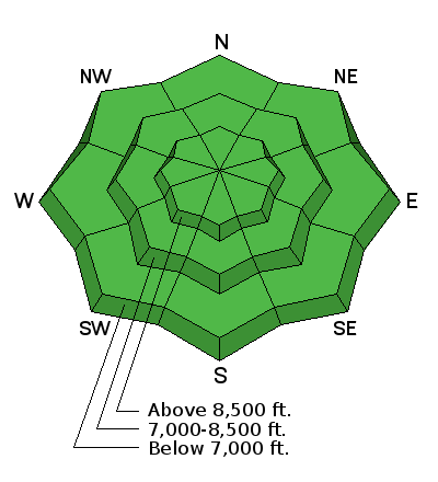
Pockets of soft and hard wind drifts exist across the range though they are getting very stubborn. Look for slightly rounded, smooth pillows and areas with more of a scalloped appearance. Remember that with soft slabs, you're "in" the snow; for hard slabs, you're "on top of" it. Treat wind-damaged terrain with suspicion today. Winds are forecast to increase this afternoon and any dry snow left will be available for transport - avoid steep slopes with freshly wind-drifted snow. |
| type | aspect/elevation | characteristics |
|---|

|

|
LIKELIHOOD
LIKELY
UNLIKELY
SIZE
LARGE
SMALL
TREND
 INCREASING DANGER
SAME
DECREASING DANGER
|
|
description
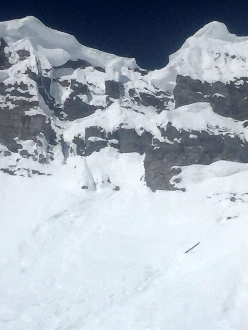
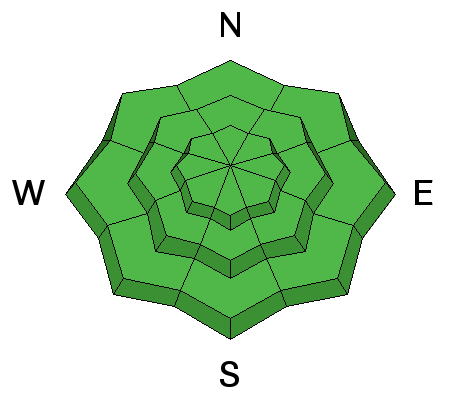
Remember that risk is inherent in mountain travel. One can never diminish it entirely and for some of us this is part of the attraction. To minimize our exposure we can travel in appropriate terrain and strive to understand snow and avalanches. Confidence in your and your partners rescue skills is imperative. We are moving into the season where early starts and early departures should become standard. With that - Shallow damp push-alanches and small loose wet avalanches may be possible with daytime warming, particularly in wind protected, sun drenched terrain. Slide-for-life conditions from last week's rain event also exist in some steep terrain. Cornices continue to be suspect along the ridgelines. Stay well back from the edge.
Though this skier-triggered cornice break is near Jackson, WY, it clearly demonstrates the harsh consequences of getting too close to the edge. (The unlucky skier fell 1000' vertical and remains in critical condition.) |
 |
weather Weather looks like real spring with warming temps and abundant sunshine. Winds are forecast to bump up a bit during the day. Today: Mostly sunny, with a high near 44. Southwest wind 10 to 20 mph. For Ogden mountain weather, click here. |
| general announcements CLICK HERE FOR MORE GENERAL INFO AND FAQ The UAC has new support programs with Outdoor Research and Darn Tough. Support the UAC through your daily shopping. When you shop at Smith's, or online at Outdoor Research, REI, Backcountry.com, Darn Tough, Patagonia, NRS, Amazon, eBay a portion of your purchase will be donated to the FUAC. See our Donate Page for more details on how you can support the UAC when you shop. Benefit the Utah Avalanche Center when you buy or sell on eBay - set the Utah Avalanche Center as a favorite non-profit in your eBay account here and click on eBay gives when you buy or sell. You can choose to have your seller fees donated to the UAC, which doesn't cost you a penny This information does not apply to developed ski areas or highways where avalanche control is normally done. This advisory is from the U.S.D.A. Forest Service, which is solely responsible for its content. This advisory describes general avalanche conditions and local variations always occur. |