25th Annual Black Diamond Fall Fundraising Party
Thursday, September 13; 6:00-10:00 PM; Black Diamond Parking Lot
25th Annual Black Diamond Fall Fundraising Party
Thursday, September 13; 6:00-10:00 PM; Black Diamond Parking Lot
| Advisory: Ogden Area Mountains | Issued by Paige Pagnucco for Friday - March 23, 2018 - 5:40am |
|---|

|
bottom line The avalanche danger is CONSIDERABLE. Dangerous avalanche consitions exist - careful snowpack evaluation, cautious route-finding, and conservative decision making are essential for safe travel today in the backcountry. Recent heavy rain and snow have created complex conditions - loose wet as well as deeper slab avalanches are major concerns today. Avoid steep slopes today. The safest and best riding conditions will be on low-angle, upper elevation slopes.
|
 |
special announcement Like puppies? Head over to Alleged on Wednesday, March 28 at 6pm to support the Snowbasin Avalanche Rescue Dog program. Details here. =========================================================================================================================== On Thursday, March 8th, two skiers were caught in an avalanche on Kessler Peak in Big Cottonwood Canyon. They were extremely lucky and were not injured or buried. An interesting component to this avalanche was how they got there in the first place. Read about it here. There is something of a cultural change happening in our community and it's an amazing and radical transformation toward openness and reflection in regards to avalanche involvements and close calls. At our avalanche discussion at the RockSteady studio Monday night, we had 65 in attendance. At least three people involved in avalanches this winter were there to discuss their experiences. This wouldn't have happened 10-15 years ago. I've written about Shame before. Tom Diegel wrote another great piece here. |
 |
current conditions It was a soaker yesterday - along with very strong winds, the Ogden area mountains picked up anywhere from 1-2" of water in the last 24 hours. The rain/snow line stayed well above 9000' until the cold front passed through around midnight bringing cooler temps and essentially switching off the wind. Temperatures currently hover near 30 F and winds are light out of the west. It won't exactly be a powder day but there is fresh snow on the ground, albeit a little cement-like. There is a fair amount of uncertainty as to how the snowpack will react to the new "load" - when in doubt, choosing lower angle terrain away from and not connected to slopes steeper than 30 degrees is always the safest bet. 24 hour totals: Ben Lomond - 1.0" water - 3" snow |
 |
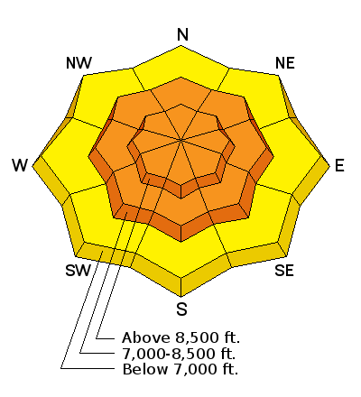
recent activity Loose wet activity was observed yesterday. |
| type | aspect/elevation | characteristics |
|---|

|
|
LIKELIHOOD
 LIKELY
UNLIKELY
SIZE
 LARGE
SMALL
TREND
 INCREASING DANGER
SAME
DECREASING DANGER
|
|
description
The snowpack has taken a real beating - adding 1-2" of water (and snow water equivalent) in the past 24 hours is like adding another floor onto a house that's supported by toothpicks. It can only take so much weight before it fails. The snowpack is saturated and soggy. Loose wet avalanches were observed yesterday and there will be more today due to a poor overnight refreeze and forecast above-freezing daytime temperatures. The storm is expected to clear out quickly and with some sunshine expected this afternoon, the new storm snow may heat up and create a fresh cycle of wet activity. Avoid steep slopes with soggy, saturated snow. Though there is not enough snow to trigger this type of avalanche at low elevations, be mindful of the terrain above you as wet avalanches can travel far distances and come from out of sight. Fresh pinwheels or rollerballs are a sure sign of instability.
|
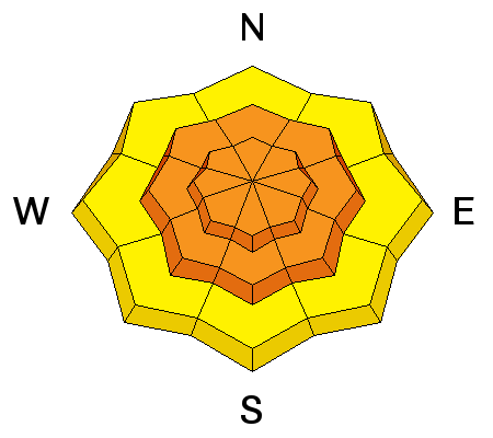
| type | aspect/elevation | characteristics |
|---|

|
|
LIKELIHOOD
LIKELY
UNLIKELY
SIZE
LARGE
SMALL
TREND
INCREASING DANGER
SAME
DECREASING DANGER
|
|
description
With 1-2" of rain and snow water equivalent, we've added a great amount of stress to a generally weak snowpack. Weak, faceted snow still exists near the ground on mid and high elevation slopes. What didn't naturally avalanche yesterday or overnight, might be hanging in the balance today just waiting for a trigger. Avalanches 1-3' deep are possible with the most problematic areas in steep rocky terrain above 8000' on north to east facing slopes. Backcountry terrain adjacent to Snowbasin will be extremely dangerous over the next couple of days. |
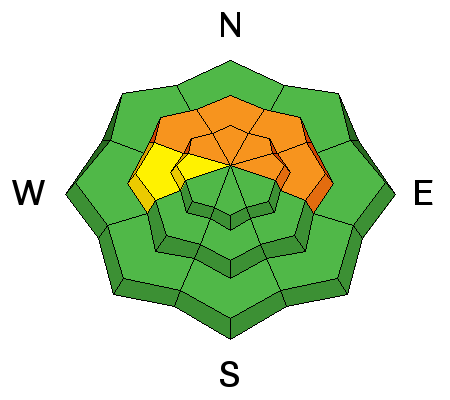
| type | aspect/elevation | characteristics |
|---|

|
|
LIKELIHOOD
 LIKELY
UNLIKELY
SIZE
 LARGE
SMALL
TREND
 INCREASING DANGER
SAME
DECREASING DANGER
|
|
description
Southerly winds were cranking yesterday but mostly when it was raining. Once the cold front moved through and snow began to fall, winds calmed down rapidly. Wind slab activity will be most likely in upper elevation exposed terrain and along ridge lines. Avoid steep slopes with freshly wind drifted snow. Even a small wind slab avalanche could be enough weight to trigger something deeper and more dangerous. |
 |
weather The Ogden mountains could pick up a few more inches of snow this morning and maybe see a little sunshine this afternoon. 8000' temps will creep upward again topping out near 40F is some areas. West southwest winds should remain fairly benign throughout the day. An unsettled pattern moves into place for the weekend bringing with it cooler temps and a chance for more snow. Check out our Ogden weather page here. |
| general announcements CLICK HERE FOR MORE GENERAL INFO AND FAQ The UAC has new support programs with Outdoor Research and Darn Tough. Support the UAC through your daily shopping. When you shop at Smith's, or online at Outdoor Research, REI, Backcountry.com, Darn Tough, Patagonia, NRS, Amazon, eBay a portion of your purchase will be donated to the FUAC. See our Donate Page for more details on how you can support the UAC when you shop. Benefit the Utah Avalanche Center when you buy or sell on eBay - set the Utah Avalanche Center as a favorite non-profit in your eBay account here and click on eBay gives when you buy or sell. You can choose to have your seller fees donated to the UAC, which doesn't cost you a penny This information does not apply to developed ski areas or highways where avalanche control is normally done. This advisory is from the U.S.D.A. Forest Service, which is solely responsible for its content. This advisory describes general avalanche conditions and local variations always occur. |


