25th Annual Black Diamond Fall Fundraising Party
Thursday, September 13; 6:00-10:00 PM; Black Diamond Parking Lot
25th Annual Black Diamond Fall Fundraising Party
Thursday, September 13; 6:00-10:00 PM; Black Diamond Parking Lot
| Advisory: Ogden Area Mountains | Issued by Drew Hardesty for Wednesday - March 7, 2018 - 7:32am |
|---|

|
bottom line The danger is along the high end of MODERATE for human triggered slides 1-3' deep and a couple hundred feet wide on west to northwest to east facing slopes above about 8000'. The danger for wet avalanches on the steep sunny aspects may rise to CONSIDERABLE with direct sun and daytime heating. Roof-a-lanches are likely and have resulted in fatalities in years past.
|
 |
special announcement We have discount lift tickets for Alta, Snowbird, Brighton, Solitude, Snowbasin,and Beaver Mountain. Details and order information here. All proceeds from these go towards paying for avalanche forecasting and education! We need your help with social media -
|
 |
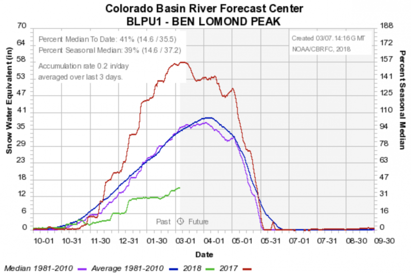
current conditions Skies are mostly clear with a few high pink streamers moving overhead. Mountain temps are in the upper teens to low twenties. Winds are light from the west. Snow depths range from 40-50" on the Ogden skyline and 50-60" in the Powder Mountain and Monte Cristo areas. Comparisons of this year (green) with last year (red) and "average" (blue/purple) for the Ben Lomond and Monte Cristo areas. Sunny aspects will have a melt freeze crust while sheltered slopes ski and ride well.
Excellent reports from the past three days below - |
 |
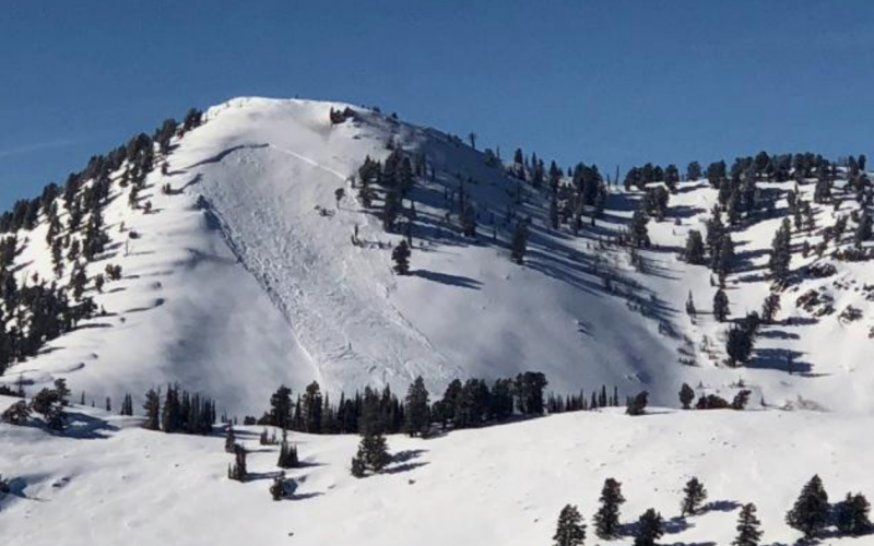
recent activity Explosive work with avalanche reduction resulted in a couple very large avalanches in the Powder Mountain area yesterday. These were 2-5' deep - some stepping to the ground - on steep NE and ESE facing slopes above 9000' near James Peak. (PC PM snow safety).
|
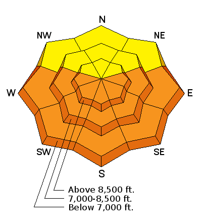
| type | aspect/elevation | characteristics |
|---|

|

|
LIKELIHOOD
 LIKELY
UNLIKELY
SIZE
 LARGE
SMALL
TREND
 INCREASING DANGER
SAME
DECREASING DANGER
|
|
description
Persistent slab avalanches are notoriously unpredictable and are aptly named. Poor structure exists above about 8000' on the shady aspects and may be triggered by heavy loads or by finding a thinner snowpack area. An avalanche triggered in the backcountry north of Snowbasin in Hells Canyon before this weekend's storm was a good warning that with the additional load of snow more like that can occur. Low angle terrain rides well without the hazard. |
| type | aspect/elevation | characteristics |
|---|

|
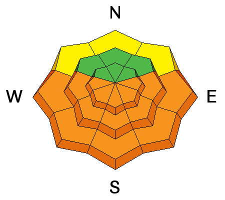
|
LIKELIHOOD
 LIKELY
UNLIKELY
SIZE
 LARGE
SMALL
TREND
 INCREASING DANGER
SAME
DECREASING DANGER
|
|
description
The temperatures and just enough wind kept the sunny aspects in check yesterday. A melt-freeze crust will exist this morning on these aspects and this will slow down the wet activity, but not thwart it by any means. So...early direct sun, temps warming to the 40s at the mid-elevation, and perhaps some later afternoon greenhousing will activate the wet avalache activity. Natural and human triggered wet avalanches will be likely and may subsequently trigger still-stabilizing storm slabs on the way downslope. I expect there may be decent debris piles beneath the steepest, most sustained avalanche slopes. Don't overstay your welcome - the window will be quite narrow between breakable crust and wet/unstable. Choose the cold snow instead. KEY POINT: ROOF-A-LANCHES will be a significant concern. Watch for many houses to shed their winter coats with the sun and daytime heating. Fatalities have occurred due to this very real hazard. |
 |
weather We'll have high clouds today that should thicken and lower by the afternoon. Greenhousing is possible. Mountain temperatures along the ridglines will rise to the upper 20s as mid-elevation temps will rise to the upper 30s to low 40s. Winds will be light from the west. A weak system pushes through Friday/Sat. The next storm looks to be a week out. |
| general announcements CLICK HERE FOR MORE GENERAL INFO AND FAQ The UAC has new support programs with Outdoor Research and Darn Tough. Support the UAC through your daily shopping. When you shop at Smith's, or online at Outdoor Research, REI, Backcountry.com, Darn Tough, Patagonia, NRS, Amazon, eBay a portion of your purchase will be donated to the FUAC. See our Donate Page for more details on how you can support the UAC when you shop. Benefit the Utah Avalanche Center when you buy or sell on eBay - set the Utah Avalanche Center as a favorite non-profit in your eBay account here and click on eBay gives when you buy or sell. You can choose to have your seller fees donated to the UAC, which doesn't cost you a penny This information does not apply to developed ski areas or highways where avalanche control is normally done. This advisory is from the U.S.D.A. Forest Service, which is solely responsible for its content. This advisory describes general avalanche conditions and local variations always occur. |