25th Annual Black Diamond Fall Fundraising Party
Thursday, September 13; 6:00-10:00 PM; Black Diamond Parking Lot
25th Annual Black Diamond Fall Fundraising Party
Thursday, September 13; 6:00-10:00 PM; Black Diamond Parking Lot
| Advisory: Ogden Area Mountains | Issued by Paige Pagnucco for Sunday - March 4, 2018 - 5:43am |
|---|


|
bottom line The avalanche danger is CONSIDERABLE and could rise to HIGH during the day due to wind and heavy snowfall. Dangerous avalanche conditions exist in the Ogden area mountains and travel in avalanche terrain is not recommended. Recent high winds and expected heavy snowfall have created a complex problem - natural avalanches are possible and human-triggered avalanches are likely on slopes steeper than about 30 degrees. Choose less complex terrain for safe travel today. Stay off of and out from under steep slopes at all elevations and avoid travel near or through any avalanche runout zones. The safest riding today will be on slopes less than 30 degrees and unconnected to any steeper terrain.
|
 |
special announcement To get help in an emergency (to request a rescue) in the Wasatch, call 911. Be prepared to give your GPS coordinates or the run name. If you trigger an avalanche in the backcountry, but no one is hurt and you do not need assistance, please notify the nearest ski area dispatch to avoid a needless response by rescue teams. Thanks.
***************************************************************************************************************************************************************************************** Episode 6 of the UAC podcast "A Conversation with Tom Kimbrough, Hemingway of the Wasatch" is live. We explore ideas about lifetime exposure to risk and what role Buddhism has played in his life as a climber, as a skier, and as a soon-to-be octogenarian. We talk about what has changed over the years in snow science and the role of mentorship in the world of forecasting and other professions and pursuits. Check it out on ITunes, Stitcher, the UAC blog. We have discount lift tickets for Alta, Snowbird, Brighton, Solitude, Snowbasin,and Beaver Mountain. Details and order information here. All proceeds from these go towards paying for avalanche forecasting and education! The UAC Marketplace is still open. Our online marketplace still has deals on skis, packs, airbag packs, beacons, snowshoes, soft goods and much more. |
 |
current conditions Well it's finally here! Sort of. Snowfall began early this morning and the Ogden area mountains have picked up 2-6" so far. Temperatures are in the teens F and winds are blowing 10-15 mph out of the northwest with ridgetop gusts in the 30's mph. The National Weather has backed off of super high forecasted snow totals and it looks like the mountains will pick up another foot by the end of the day which still isn't too shabby. Remember though that the winds cranked over the past two days so now wind slabs are buried beneath the new snow. Your best bet for safe, good riding conditions is in lower angle, sheltered terrain away from and not connected to any slopes steeper than about 30 degrees. With cooler temps today I expect the snow to be pretty nice, kind of light and fluffy. For updated mountain weather conditions, check out our new OGDEN WEATHER PAGE. *The Bountiful bench has already picked up almost 10".
|
 |
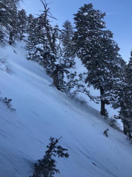
recent activity Ski area control teams reported stubborn wind slabs yesterday as well as a 3' deep avalanche that broke into very old, weak snow. Wednesday, 2 separate slides were triggered in Hells Canyon, both at 8500', on northerly facing slopes, and running 2000' vertical feet down into the gully bottom. We appreciate your backcountry observations - let us know what you're seeing out there HERE. Wednesday Feb. 28, Snowboard triggered slide, Hells Canyon. pc: Snowbasin patrol.
|
| type | aspect/elevation | characteristics |
|---|

|
|
LIKELIHOOD
 LIKELY
UNLIKELY
SIZE
 LARGE
SMALL
TREND
 INCREASING DANGER
SAME
DECREASING DANGER
|
|
description
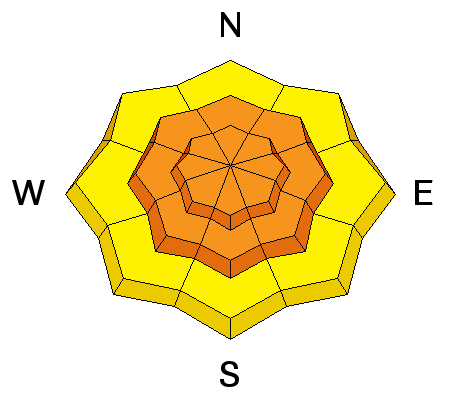
We have had two days of very strong winds and wind slabs have formed in exposed upper and mid elevation terrain as well as on or around terrain features like subridges and gullies on exposed slopes off the ridgelines. Heavy snowfall today will bury existing wind slabs underneath making them hard to see. Winds are forecast to increase this afternoon and, with wind slabs building on top of wind slabs, it'll be safest to avoid steep slopes with freshly wind drifted snow and look for obvious signs of instability like cracking or collapsing. (click here to learn more about wind slabs.) Getting caught in even a small windslab could be dangerous as it could step down into older, weak snow and become bigger and more consequential. Cornices are becoming more widespread along ridgelines and will continue to grow larger and more sensitive with today’s winds and heavy snowfall. Cornices often break back further than expected, on to what looks like flat terrain. Give them a wide berth and avoid travel below them. |
| type | aspect/elevation | characteristics |
|---|

|
|
LIKELIHOOD
LIKELY
UNLIKELY
SIZE
 LARGE
SMALL
TREND
INCREASING DANGER
SAME
DECREASING DANGER
|
|
description
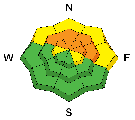
Though weak layers are getting buried deeper beneath the new snow, recent triggered avalanches on buried layers of faceted snow on steep slopes show dangerous conditions exist in the Ogden area mountains. Many slopes have poor structure – soft sugary, weak layers, both mid-pack and near the ground. It seems some of the steep slopes are just waiting for a trigger, like more weight from snow and wind or a rider. It's hard to predict which slopes will slide though those facing northerly through easterly are the most likely and should be avoided, especially in continuously steep terrain or terrain with gullies, trees or cliff bands. This type of avalanche has the potential to run far down into low elevation terrain as evidenced by Wednesday's Hells Canyon slides so avoid travel under steep northwest through east facing slopes. Getting caught in this type of avalanche could be unsurvivable. As with wind slabs, cracking and collapsing are bulls-eye clues to instability, but for persisent slabs these clues may not be present, and snow pit tests could be unreliable. To learn more about persisent slab and other types of avalanche problems, click here. |
| type | aspect/elevation | characteristics |
|---|

|
|
LIKELIHOOD
LIKELY
UNLIKELY
SIZE
LARGE
SMALL
TREND
INCREASING DANGER
SAME
DECREASING DANGER
|
|
description
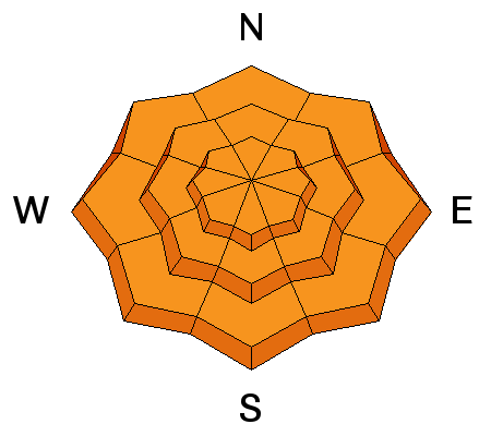
Though not across the entire Ogden zone, areas of high snowfall intensity will create 1-2' deep storm snow avalanches very quickly during the day. The Bountiful bench has already picked up 9+ " so even travelers on low elevation trails should avoid crossing or being under steeper terrain today. With conditions changing so rapidly, the safest option is to stay of off all slopes steeper than about 30 degrees to avoid this problem. |
 |
weather A WINTER STORM WARNING is in effect until 10pm tonight. Wind and heavy snowfall are anticipated across most of the Ogden zone today, though some areas will receive much more than others. Temperatures will only get into the teens and will get cooler as the day goes on. Westerly winds will blow 20-30 mph with gusts near 40+ mph. The foreacst for this storm has been a bit inconsistent but the mountains in general should hopefully end up with about a foot or more of snow by tonight. The storm clears out by Monday making way for partly sunny skies and daytime highs near 20 F. If you choose to travel in the backcountry today be prepared for winter weather conditions. |
| general announcements CLICK HERE FOR MORE GENERAL INFO AND FAQ The UAC has new support programs with Outdoor Research and Darn Tough. Support the UAC through your daily shopping. When you shop at Smith's, or online at Outdoor Research, REI, Backcountry.com, Darn Tough, Patagonia, NRS, Stio, Amazon, and eBay, a portion of your purchase will be donated to the FUAC. See our Donate Page for more details on how you can support the UAC when you shop. Benefit the Utah Avalanche Center when you buy or sell on eBay - set the Utah Avalanche Center as a favorite non-profit in your eBay account here and click on eBay gives when you buy or sell. You can choose to have your seller fees donated to the UAC, which doesn't cost you a penny This information does not apply to developed ski areas or highways where avalanche control is normally done. This advisory is from the U.S.D.A. Forest Service, which is solely responsible for its content. This advisory describes general avalanche conditions and local variations always occur. |