25th Annual Black Diamond Fall Fundraising Party
Thursday, September 13; 6:00-10:00 PM; Black Diamond Parking Lot
25th Annual Black Diamond Fall Fundraising Party
Thursday, September 13; 6:00-10:00 PM; Black Diamond Parking Lot
| Advisory: Ogden Area Mountains | Issued by Paige Pagnucco for Friday - March 2, 2018 - 5:32am |
|---|

|
bottom line The Utah Avalanche Center has issued an AVALANCHE WATCH for dangerous avalanche conditions developing later today and into this weekend. The avalanche danger is CONSIDERABLE. Dangerous avalanche conditions exist on steep, upper elevation slopes with freshly wind drifted snow. Wind drifts can be found around the compass, both along and well off the ridges and will increase in depth and distribution throughout the day. With recent human-triggered persistent slab avalanches, north through east facing mid and upper elevation slopes that have weak, faceted layers should be avoided. Stay well back from cornices as they tend to break back further than you think. With the complex snowpack, continue to use cautious route finding, careful snowpack evaluation and conservative decision-making. Terrain is your friend today as you'll find better and safer skiing and riding conditions on lower-angled, wind sheltered slopes, with no steep slopes above.
|
 |
avalanche watch * TIMING…IN EFFECT FROM 6 AM MST THIS MORNING TO 6 AM MST SATURDAY * AFFECTED AREA…FOR THE MOUNTAINS OF NORTHERN AND CENTRAL UTAH INCLUDING THE WASATCH RANGE...BEAR RIVER RANGE...UINTA MOUNTAINS...AND THE MANTI-SKYLINE AND WASATCH PLATEAU. * AVALANCHE DANGER…THE AVALANCHE DANGER FOR THE WARNING AREA IS CONSIDERABLE AND IS EXPECTED TO RISE TO HIGH BY SATURDAY. * IMPACTS…STRONG WINDS AND HEAVY SNOWFALL WILL LIKELY CREATE DANGEROUS AVALANCHE CONDITIONS BY LATER TODAY, AND CONTINUING INTO MONDAY. BOTH HUMAN TRIGGERED AND NATURAL AVALANCHES ARE LIKELY. STAY OFF OF AND OUT FROM UNDER SLOPES STEEPER THAN 30 DEGREES. BACKCOUNTRY TRAVELERS SHOULD CONSULT WWW.UTAHAVALANCHECENTER.ORG OR CALL 1-888-999-4019 FOR MORE DETAILED INFORMATION. THIS WARNING DOES NOT APPLY TO SKI AREAS WHERE AVALANCHE HAZARD REDUCTION MEASURES ARE PERFORMED. |
 |
special announcement To get help in an emergency (to request a rescue) in the Wasatch, call 911. Be prepared to give your GPS coordinates or the run name. If you trigger an avalanche in the backcountry, but no one is hurt and you do not need assistance, please notify the nearest ski area dispatch to avoid a needless response by rescue teams. Thanks.
Episode 6 of the UAC podcast "A Conversation with Tom Kimbrough, Hemingway of the Wasatch" is live. We explore ideas about lifetime exposure to risk and what role Buddhism has played in his life as a climber, as a skier, and as a soon-to-be octogenarian. We talk about what has changed over the years in snow science and the role of mentorship in the world of forecasting and other professions and pursuits. Check it out on ITunes, Stitcher, the UAC blog. We have discount lift tickets for Alta, Snowbird, Brighton, Solitude, Snowbasin,and Beaver Mountain. Details and order information here. All proceeds from these go towards paying for avalanche forecasting and education! The UAC Marketplace is still open. Our online marketplace still has deals on skis, packs, airbag packs, beacons, snowshoes, soft goods and much more. |
 |
current conditions Temperatures this morning are in the 20's F and winds are still howling in the Ogden area mountains with Ogden Peak averaging 45+ mph with 70 mph gusts overnight. A strong storm system is moving in for the weekend bringing with it the potential for 1-2 feet of snow by Sunday. Expect stormy conditions to develop today especially due to strong winds. Riding conditions are variable with sheltered, low angle slopes facing the northern part of the compass holding the best hope for softer snow. Ogden Peak Weather Station:
|
 |
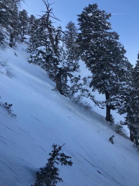
recent activity Wednesday, 2 separate slides were triggered in Hells Canyon, both at 8500', on northerly facing slopes, and running 2000' vertical feet down into the gully bottom. Luckily, no one was caught in these slides. One soft slab was triggered remotely, 100' wide by 2 feet deep. The other was triggered by a snowboarder, 40 feet wide by 18" deep. Both failed on facets. The second slide was not reported, so not knowing if someone was caught, a dangerous search was completed by the Snowbasin ski patrol that proved needless. Snowpit tests on other upper elevation, northerly facing slopes continue to show poor structure, with full propagation on faceted weak layers, and collapsing. Slides were also triggered with explosives along high ridge lines. Snowboard triggered slide, Hells Canyon. pc: Snowbasin patrol.
Debris from the Hells Canyon slide. pc: Snowbasin patrol.
|
| type | aspect/elevation | characteristics |
|---|

|
|
LIKELIHOOD
 LIKELY
UNLIKELY
SIZE
 LARGE
SMALL
TREND
 INCREASING DANGER
SAME
DECREASING DANGER
|
|
description
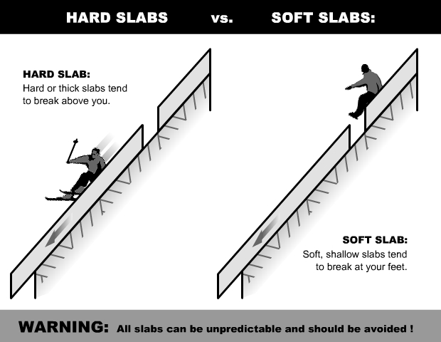
Winds cranked overnight in the Ogden area mountains - see graph in current conditions - and will continue to be the main influencer today as speeds are expected to average in the 30's mph with gusts upwards of 50+ mph. Though they'll blow primarily from the south, all aspects will be affected. Wind drifted snow will quickly form stiff wind slabs near ridgelines and crossloading will likely occur on or around terrain features like subridges and gullies on exposed slopes off the ridgelines. Avoid steep slopes with freshly wind drifted snow and look for obvious signs of instability like cracking or collapsing. See below for a great graphic describing the difference between hard and soft slabs and where they tend to break. Expect to be dealing with hard wind slabs today. Lower angle sheltered terrain is the best option for safe riding. Cornices are becoming more widespread along ridgelines and will continue to grow with today’s strong southerly winds. Cornices often break back further than expected, on to what looks like flat terrain. Give them a wide berth and avoid travel below them. Hard slab diagram – read more about them here.
|
| type | aspect/elevation | characteristics |
|---|

|
|
LIKELIHOOD
 LIKELY
UNLIKELY
SIZE
 LARGE
SMALL
TREND
INCREASING DANGER
SAME
DECREASING DANGER
|
|
description
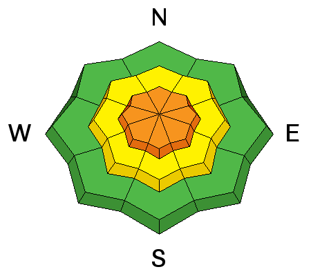
Avalanches triggered Wednesday on buried layers of faceted snow on steep slopes show dangerous conditions exist in the Ogden area mountains. Many slopes have poor structure – soft sugary, weak layers, both mid-pack and near the ground. It seems some of the steep slopes are just waiting for a trigger – and which slopes will slide are unpredictable - though slopes facing northerly through easterly are the most likely places to trigger a slide and should be avoided, especially in continuously steep terrain or slopes with terrain such as gullies, trees or cliff bands. This type of avalanche has the potential to run far down into low elevation terrain as evidenced by Wednesday's Hells Canyon slides. Avoid travel under steep northwest through east facing slopes. As with wind slabs, cracking and collapsing are bulls-eye clues to instability, but for persisent slabs these clues may not be present, and snow pit tests could be unreliable. |
 |
weather The National Weather Service has issued a Winter Storm Warning that includes the Ogden area mountains from 9am this morning until 11am Sunday morning. Expect snow and very windy conditions today. Southerly winds will blow 30-40 mph with gusts as high as 55 mph. Temperatures should hover around freezing but will feel much colder with the wind chill. Expected snowfall totals today are only 2-4 inches as the bulk of the snow is expected to arrive Saturday into Saturday night. The Ogden zone could see 1-2 feet of snow by Sunday. |
| general announcements CLICK HERE FOR MORE GENERAL INFO AND FAQ The UAC has new support programs with Outdoor Research and Darn Tough. Support the UAC through your daily shopping. When you shop at Smith's, or online at Outdoor Research, REI, Backcountry.com, Darn Tough, Patagonia, NRS, Stio, Amazon, and eBay, a portion of your purchase will be donated to the FUAC. See our Donate Page for more details on how you can support the UAC when you shop. Benefit the Utah Avalanche Center when you buy or sell on eBay - set the Utah Avalanche Center as a favorite non-profit in your eBay account here and click on eBay gives when you buy or sell. You can choose to have your seller fees donated to the UAC, which doesn't cost you a penny This information does not apply to developed ski areas or highways where avalanche control is normally done. This advisory is from the U.S.D.A. Forest Service, which is solely responsible for its content. This advisory describes general avalanche conditions and local variations always occur. |