25th Annual Black Diamond Fall Fundraising Party
Thursday, September 13; 6:00-10:00 PM; Black Diamond Parking Lot

25th Annual Black Diamond Fall Fundraising Party
Thursday, September 13; 6:00-10:00 PM; Black Diamond Parking Lot
| Advisory: Ogden Area Mountains | Issued by Evelyn Lees for Wednesday - February 28, 2018 - 7:30am |
|---|
 |
special announcement Spend some time improving your rescue skills or learning about avalanches in this upcoming Salt Lake City area class:
|
 |
current conditions Skies are partly cloudy this morning, and the Ogden area mountains have recieved 1 to 3" of snow in the past 48 hours. Temperatures are in the teens and twenties, with a few single digits at the highest elevations. The southwest to westerly winds are as quiet as they’ve been lately – averaging 5 to 10 mph, with even the highest peaks only averaging 15 to 22 mph. While there is wind damage on many aspects and sun crusts on some southerly facing slopes, soft dense powder remains on sheltered, shady slopes. Snotel snow depths are now: Ben Lomond peak - 52”, Ben Lomond trailhead - 22”. Farmington and Monte Cristo have around 52” of snow on the ground. |
 |
recent activity Reports from the Ogden area moutains were of small soft and hard wind slabs and cornices, sensitive to skiers. Mark Staples was near Grandview yesterday, and saw a larger slide from earlier this week and a more recent smaller wind slab. Photos below.
|
| type | aspect/elevation | characteristics |
|---|


|


|

LIKELIHOOD
 LIKELY
UNLIKELY
SIZE
 LARGE
SMALL
TREND
 INCREASING DANGER
SAME
DECREASING DANGER
|
|
description
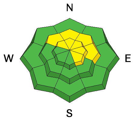
Monday’s strong southwesterly winds built pencil hard wind slabs, along ridge lines and scattered down in open bowls and the mid elevations. While they will be more stubborn today, they still can be triggered by a person, and be anywhere from a few inches to two feet deep. Hard slabs are different from the soft wind drifts we’ve been dealing with lately – they almost always break above you, and often on the second or third person. New hard cornices have grown along ridgelines. Hard cornices break back even further, often onto what looks like flat terrain on the ridge. So give them a wide berth and avoid travel below them. Left - hard slab diagram – read more about them here.
|
| type | aspect/elevation | characteristics |
|---|


|


|

LIKELIHOOD
 LIKELY
UNLIKELY
SIZE
 LARGE
SMALL
TREND
 INCREASING DANGER
SAME
DECREASING DANGER
|
|
description
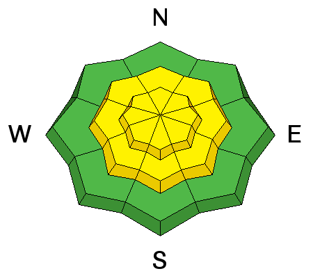
Variable and unpredictable – how to define our current faceted weak layers that exist in both the mid pack and near the ground. The weakest mid pack layers average 1 to 2 feet deep, and can involve facets near buried crusts. In the shallower snowpack areas, a few slides could break near the ground, especially on slopes that have avalanched one or more times this year. Avoid, steep shallow, rocky, wind loaded terrain, where the snowpack is thinner and more suspect. If you trigger a persistent slab avalanche it will likely be unsurvivable. Cracking and collapsing are bulls-eye clues to instability, but these clues may not be present, and snow pit tests could be unreliable. |
 |
weather Today will be the last calm, quiet day this week. The morning’s clouds should thin rapidly, and skies become partly to mostly sunny. The westerly winds will remain light all day, averaging 5 to 15 mph, with the highest peaks only averaging to 20 mph. Temperatures will warm into the upper teens to mid 20s, perhaps near 30 at trail heads. The next storm continues to look good – light snow and increasing winds Thursday, strong winds Friday, with the cold front arriving Friday night, and periods of snow, heavy at times, possible through Sunday. |
| general announcements CLICK HERE FOR MORE GENERAL INFO AND FAQ The UAC has new support programs with Outdoor Research and Darn Tough. Support the UAC through your daily shopping. When you shop at Smith's, or online at Outdoor Research, REI, Backcountry.com, Darn Tough, Patagonia, NRS, Amazon, eBay a portion of your purchase will be donated to the FUAC. See our Donate Page for more details on how you can support the UAC when you shop. Benefit the Utah Avalanche Center when you buy or sell on eBay - set the Utah Avalanche Center as a favorite non-profit in your eBay account here and click on eBay gives when you buy or sell. You can choose to have your seller fees donated to the UAC, which doesn't cost you a penny This information does not apply to developed ski areas or highways where avalanche control is normally done. This advisory is from the U.S.D.A. Forest Service, which is solely responsible for its content. This advisory describes general avalanche conditions and local variations always occur. |