25th Annual Black Diamond Fall Fundraising Party
Thursday, September 13; 6:00-10:00 PM; Black Diamond Parking Lot
25th Annual Black Diamond Fall Fundraising Party
Thursday, September 13; 6:00-10:00 PM; Black Diamond Parking Lot
| Advisory: Ogden Area Mountains | Issued by Evelyn Lees for Tuesday - February 27, 2018 - 6:49am |
|---|

|
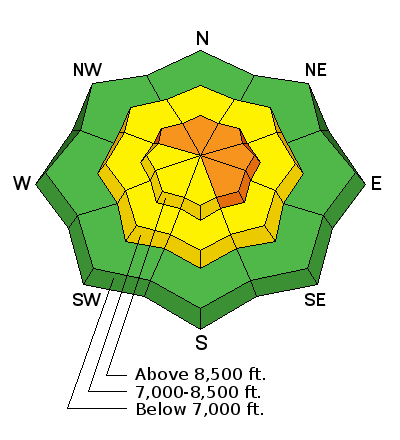
bottom line The avalanche danger is CONSIDERABLE on steep, upper elevation slopes facing northwest through southeasterly, especially those with recent wind drifts. Other steep slopes have a MODERATE danger. Complex and dangerous avalanche conditions exist – cautious route finding, careful snowpack evaluation and conservative decision making essential. You will find better and safer skiing and riding conditions on lower-angled wind sheltered slopes, with no steep slopes above.
|
 |
special announcement We have discount lift tickets for Alta, Snowbird, Brighton, Solitude, Snowbasin, and Beaver Mountain. Details and order information here. All proceeds from these go towards paying for avalanche forecasting and education! |
 |
current conditions Skies are mostly to partly cloudy in the Ogden area mountains this morning, with light snow still falling in isolated areas. The east side of the valley picked up 2 ½ inches of snow yesterday. The southwesterly winds have decreased significantly from yesterday, averaging less than 10 mph at most mid elevation stations, with speeds of 15 to 25 mph, gusting in the 30s, at the highest elevations. Temperatures are in the twenties, with teens along the high ridge lines. While there is widespread wind damage, some good soft snow was still reported on very wind sheltered slopes. |
 |
recent activity Yesterday, there were reports of heavy drifting, creating dense pockety wind slabs, ranging from sensitive to stubborn. The Ogden area resorts reported 2 significant slides. One was a large slide triggered by an intentional ski cut on a north-facing slope, in a protected treed area at about 8,500’. The other was a hard slab 4 feet deep by 60 feet wide on an easterly aspect at 8500’, triggered by the second ski cut, not the first. It failed on facets above a crust.
|
| type | aspect/elevation | characteristics |
|---|

|

|
LIKELIHOOD
 LIKELY
UNLIKELY
SIZE
 LARGE
SMALL
TREND
 INCREASING DANGER
SAME
DECREASING DANGER
|
|
description
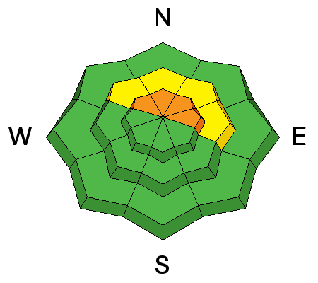
Yesterday’s strong winds built soft and harder wind slabs in both mid and upper elevation terrain. Today, occasionally moderate south to southwesterly winds will keep these drifts fresh and sensitive to the weight of a rider. You can expect the drifts to be 1-2' deep and most pronounced on northwest through southeast facing terrain. There is also potential that if you trigger a wind slab it could then step down into deeper weaker layers in the snowpack. Cornices have continued to grow along the mid and upper elevation ridgelines. They often break back further than expected, so give them a wide berth and avoid travel below them. |
| type | aspect/elevation | characteristics |
|---|

|
|
LIKELIHOOD
 LIKELY
UNLIKELY
SIZE
 LARGE
SMALL
TREND
INCREASING DANGER
SAME
DECREASING DANGER
|
|
description
On some slopes, the faceted layers in our snowpack are very near their breaking point, and just waiting for a trigger. These deeper slides could be 2 to 4 feet deep, and could break on a mid-pack facet/crust weak layer, or even to the ground. Any smaller triggered slide – such as a wind slabs or sluff – has the potential to step down to one of these deeper weak layers. Avoid, steep shallow, rocky, wind loaded terrain, where the snowpack is thinner and more suspect. If you trigger a persistent slab avalanche it will likely be unsurvivable. Cracking and collapsing are bulls-eye clues to instability, but these clues may not be present, and snow pit tests could be unreliable. |
 |
weather Southerly winds and clouds will continue for much of the day. There is a chance the sun will pop out here and there followed by a scattered snow shower. Wind speeds should be confined to 15-25 mph across the high terrain, with gusts in the 30s. Temperatures warm up into the mid twenties to low 30s °F before cooling off this evening. The good news - we have a very organized storm that will deliver snow and water for the weekend. South winds ramp up Thursday ahead of the cold front that sweeps down out of the arctic and lands on our doorstep Friday morning lasting through the weekend |
| general announcements CLICK HERE FOR MORE GENERAL INFO AND FAQ The UAC has new support programs with Outdoor Research and Darn Tough. Support the UAC through your daily shopping. When you shop at Smith's, or online at Outdoor Research, REI, Backcountry.com, Darn Tough, Patagonia, NRS, Amazon, eBay a portion of your purchase will be donated to the FUAC. See our Donate Page for more details on how you can support the UAC when you shop. Benefit the Utah Avalanche Center when you buy or sell on eBay - set the Utah Avalanche Center as a favorite non-profit in your eBay account here and click on eBay gives when you buy or sell. You can choose to have your seller fees donated to the UAC, which doesn't cost you a penny This information does not apply to developed ski areas or highways where avalanche control is normally done. This advisory is from the U.S.D.A. Forest Service, which is solely responsible for its content. This advisory describes general avalanche conditions and local variations always occur. |


