25th Annual Black Diamond Fall Fundraising Party
Thursday, September 13; 6:00-10:00 PM; Black Diamond Parking Lot
25th Annual Black Diamond Fall Fundraising Party
Thursday, September 13; 6:00-10:00 PM; Black Diamond Parking Lot
| Advisory: Ogden Area Mountains | Issued by Evelyn Lees for Saturday - February 24, 2018 - 7:19am |
|---|


|
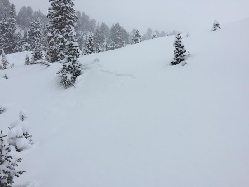
bottom line It is a day of increasing avalanche danger. The avalanche danger is CONSIDERABLE this morning on all steep, wind-drifted slopes. A MODERATE hazard also exists for triggering a deeper avalanche on steep slopes facing northwest through east at the mid and upper elevations, where a slide could fail in the older faceted snow. Evaluate snow and terrain carefully. The avalanche danger willcontinue to rise late this afternoon or overnight with stronger winds and more snow in the forecast. The Good News: Excellent riding conditions exist on wind sheltered and lower angle slopes. With over a foot of fresh, dry, classic Utah powder, today will likely offer the best of what's been an otherwise forgettable season.
|
 |
special announcement We have discount lift tickets for Alta, Snowbird, Brighton, Solitude, Snowbasin, and Beaver Mountain. Details and order information here. All proceeds from these go towards paying for avalanche forecasting and education! |
 |
current conditions What a week it’s been - an all you can eat powder buffet, and free refills on the way. Ogden area mountains have received 1 1/2 to 2 feet of snow, containing 1 1/4 to almost 2" of water weight. Cold temperatures and clouds have preserved the powder on all aspects. You may catch a glimpse of sun this morning before skies cloud up again ahead of tonight’s storm. In the Ogden area moutnains, temperatures are in the single digits above and below zero this morning, and will struggle to crawl into the teens today. The southwest to westerly winds are stronger than I would like - the mid elevations are averaging around 15 mph averages, but Mt Ogden has been averaging close to 40 mph, with gusts almost 50 mph. |
 |
recent activity Yesterday, ski area control teams found sensitive shallow wind slabs and new snow sluffing with explosives and ski cuts along the high ridgelines and around terrain features. Bill Brandt found widespread shallow sluffs in the backcountry. Observation here.
|
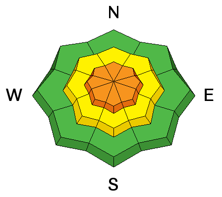
| type | aspect/elevation | characteristics |
|---|

|
|
LIKELIHOOD
 LIKELY
UNLIKELY
SIZE
 LARGE
SMALL
TREND
 INCREASING DANGER
SAME
DECREASING DANGER
|
|
description
The winds are a bit of a spoiler today – wind speeds are strong enough to drift the low-density snow and are expected to continue at the current speeds. The new wind drifts or wind slabs will cracky and easy to trigger, forming along the mid and higher elevation ridge lines. Avoid any steep slopes with wind drifts, and be aware that the drifts will become more widespread and deeper as the day progresses. Cornices will also be forming along the mid and upper elevation ridge lines. They often break back further than expected, so give them a wide berth and avoid travel below them |
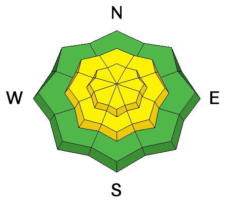
| type | aspect/elevation | characteristics |
|---|

|
|
LIKELIHOOD
 LIKELY
UNLIKELY
SIZE
LARGE
SMALL
TREND
INCREASING DANGER
SAME
DECREASING DANGER
|
|
description
Loose dry snow sluffs are possible today in steep terrain. Be mindful as getting caught in this type of avalanche can still be dangerous as you can get knocked off your feet quickly. |
| type | aspect/elevation | characteristics |
|---|

|

|
LIKELIHOOD
LIKELY
UNLIKELY
SIZE
LARGE
SMALL
TREND
 INCREASING DANGER
SAME
DECREASING DANGER
|
|
description
With several storms this past week, there is even more uncertainty with the lingering weaknesses both at the mid-pack (especially on the eastern edge of the Ogden mountains) and again with the more deeply buried early season weak layers. Tests and lack of deeper avalanches hint at good stability and yet a general poor structure of snow with faceted grains drives a conservative approach to avoid thinner snowpack areas or more consequential terrain, at least above 8000'. Cracking and collapsing are bulls-eye clues to instability, but these clues may not be present. The tipping point is unknown but this type of avalanche could easily be triggered by a smaller avalanche such as today's new wind slabs, that steps down. |
 |
weather
|
| general announcements CLICK HERE FOR MORE GENERAL INFO AND FAQ The UAC has new support programs with Outdoor Research and Darn Tough. Support the UAC through your daily shopping. When you shop at Smith's, or online at Outdoor Research, REI, Backcountry.com, Darn Tough, Patagonia, NRS, Amazon, eBay a portion of your purchase will be donated to the FUAC. See our Donate Page for more details on how you can support the UAC when you shop. Benefit the Utah Avalanche Center when you buy or sell on eBay - set the Utah Avalanche Center as a favorite non-profit in your eBay account here and click on eBay gives when you buy or sell. You can choose to have your seller fees donated to the UAC, which doesn't cost you a penny This information does not apply to developed ski areas or highways where avalanche control is normally done. This advisory is from the U.S.D.A. Forest Service, which is solely responsible for its content. This advisory describes general avalanche conditions and local variations always occur. |