25th Annual Black Diamond Fall Fundraising Party
Thursday, September 13; 6:00-10:00 PM; Black Diamond Parking Lot
25th Annual Black Diamond Fall Fundraising Party
Thursday, September 13; 6:00-10:00 PM; Black Diamond Parking Lot
| Advisory: Ogden Area Mountains | Issued by Trent Meisenheimer for Monday - February 19, 2018 - 5:28am |
|---|

|
bottom line The avalanche danger in the Ogden area mountains is CONSIDERABLE today on upper elevation slopes facing north through east, for triggering wind slabs. Avalanches can also break into the deeper weak layers on north and northeast facing slopes. If you head into the backcountry - dangerous avalanche conditions exist and careful snowpack evaluation, cautious route finding and conservative decision-making will be essential.
|
 |
current conditions Under mostly cloudy skies it's lightly snowing in places throughout the Ogden front. Near Powder Mountain 12 inches of snow (0.87 inches of SWE) fell, and the Monte Cristo area likely recieved similar amounts but the SNOTEL site stopped reporting data last night. Only 3-6 inches fell near Snowbasin. Temperatures have dropped significantly after the frontal passage, with current mountain temperatures in the 10-15°F range. Winds are from the north and averaging only 10-15 mph even across the high terrain. |
 |
recent activity There was one reported avalanche from snow safety teams yesterday - it was reported as a 200' wide, 2-3' feet deep and ran 200' feet down slope. Also reported was a few isolated hard wind slabs under the upper elevation ridge lines and around terrain features, however, they were observed to be stubborn. A list of all observations from the Ogden area found HERE. |
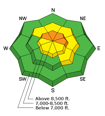
| type | aspect/elevation | characteristics |
|---|

|
|
LIKELIHOOD
 LIKELY
UNLIKELY
SIZE
 LARGE
SMALL
TREND
 INCREASING DANGER
SAME
DECREASING DANGER
|
|
description
Yesterday's strong southerly winds have created wind slabs on the lee sides of ridges and terrain features. Now the hard part, they will be covered by the new 3-12" inches of snow today, making them harder to spot. The story remains the same, be on the lookout for smooth, rounded, dense and cracky snow – they will be found along ridgelines and also well off the ridge lines, with drifts down in open bowls, along gully walls, and on mid slope break overs. Avoid wind drifts on steep slopes, which will be most widespread on the northerly through easterly facing slopes. * Heads up - the National Weather Service is thinking the northerly winds could pick up later today. With 3-12" of fluff, it will have plenty of snow available to transport and create new drifts of wind blown snow. |
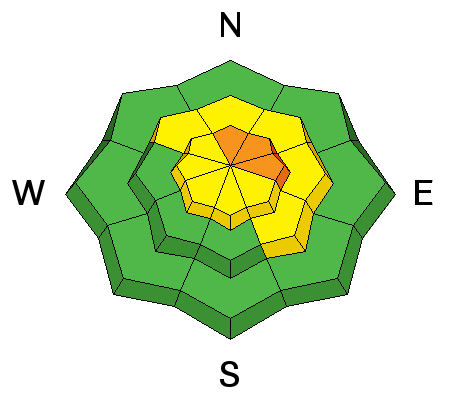
| type | aspect/elevation | characteristics |
|---|

|
|
LIKELIHOOD
LIKELY
UNLIKELY
SIZE
LARGE
SMALL
TREND
INCREASING DANGER
SAME
DECREASING DANGER
|
|
description
How much new snow and wind will it take to re-activate these dormant weak layers of faceted snow buried in our snowpack? good question... I don't think anyone has the answer. Here's what I know - anytime you load or stress the snowpack with wind or new snow the chance of triggering a persistent slab avalanche increases. Your best and only strategy for this type of avalanche is avoidance. Simply, avoid steep, shallow, wind drifted terrain that faces the north half of the compass. As they become more sensitive, they can be triggered from a distance, from below or by releasing a wind slab that then steps down. Our snowpack depths are unusually variable, and the snowpack is especially weak where it is shallow, including slopes that have slid one or more times this year. Cracking and collapsing are bulls-eye clues to instability. |
 |
weather The storm is already winding down across northern Utah. Winds will remain from the north and should be well behaved, averaging 10-20 mph with an occasional gust into the 20's. Fingers crossed that the northerly winds don't pick up as forecasted and it keeps the snow on the ground, instead of sending off to our east. Temperatures will be cold, especially in the wind. Mountain temperatures are only expected to rise into the mid to upper teens °F before cooling off again tonight. Areas that are favored by a northwest flow could see a few more inches of snow throughout the day today. |
| general announcements CLICK HERE FOR MORE GENERAL INFO AND FAQ The UAC has new support programs with Outdoor Research and Darn Tough. Support the UAC through your daily shopping. When you shop at Smith's, or online at Outdoor Research, REI, Backcountry.com, Darn Tough, Patagonia, NRS, Amazon, eBay a portion of your purchase will be donated to the FUAC. See our Donate Page for more details on how you can support the UAC when you shop. Benefit the Utah Avalanche Center when you buy or sell on eBay - set the Utah Avalanche Center as a favorite non-profit in your eBay account here and click on eBay gives when you buy or sell. You can choose to have your seller fees donated to the UAC, which doesn't cost you a penny This information does not apply to developed ski areas or highways where avalanche control is normally done. This advisory is from the U.S.D.A. Forest Service, which is solely responsible for its content. This advisory describes general avalanche conditions and local variations always occur. |


