25th Annual Black Diamond Fall Fundraising Party
Thursday, September 13; 6:00-10:00 PM; Black Diamond Parking Lot
25th Annual Black Diamond Fall Fundraising Party
Thursday, September 13; 6:00-10:00 PM; Black Diamond Parking Lot
| Advisory: Ogden Area Mountains | Issued by Mark Staples for Tuesday - February 6, 2018 - 6:59am |
|---|

|
bottom line Today the avalanche danger is MODERATE for triggering a persistent slab avalanche on upper elevation slopes that face NW through E, especially on slopes that are heavily wind loaded. Also the danger is MODERATE at upper elevations later today for triggering shallow wind slabs formed by today's WNW winds.
|
 |
special announcement Discount lift tickets for Alta, Snowbird, Brighton, Solitude, Snowbasin,and Beaver Mountain. Details and order information here. All proceeds from these go towards paying for avalanche forecasting and education! |
 |
current conditions Temperatures cooled overnight and are just below freezing in valley locations, in the 20’s F around 7000 feet, and in the upper teens F at higher elevations above 8000 feet. Winds are averaging about 10 mph from the WNW with gusts of 20 mph. Riding conditions aren’t the best. A touch of new snow Sunday night, warm temperatures the last few days, and this morning’s cold temperatures have done little to improve conditions. A few inches forecasted today will help. |
| type | aspect/elevation | characteristics |
|---|

|
|
LIKELIHOOD
 LIKELY
UNLIKELY
SIZE
 LARGE
SMALL
TREND
 INCREASING DANGER
SAME
DECREASING DANGER
|
|
description
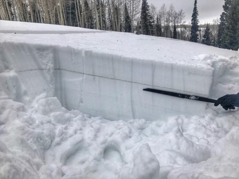
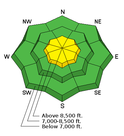
The lingering persistent slab avalanche problem exists at elevations 8500' and above, on slopes facing northwest through east. Although there is little snow available for winds to transport, avoid heavily wind-loaded slopes in these locations. As an outlier, buried surface hoar has been found in the mountains east of Hunstsville and Eden (and in the southern end of the Logan zone) and has yet to be reactive to human weight or snow tests. This layer is about 10 inches deep. Even though it has been unreactive, watch for any cracking on this layer that will tell you of an isolated area where it could produce an avalanche (Photo Below).
There is some good news. Weak facets on some slopes, especially at mid elevations, became slightly damp during recent warm weather. Today’s cold temperatures will help refreeze and strengthen buried facets on these slopes. Watch the video below or go here. |
| type | aspect/elevation | characteristics |
|---|

|

|
LIKELIHOOD
LIKELY
UNLIKELY
SIZE
 LARGE
SMALL
TREND
 INCREASING DANGER
SAME
DECREASING DANGER
|
|
description
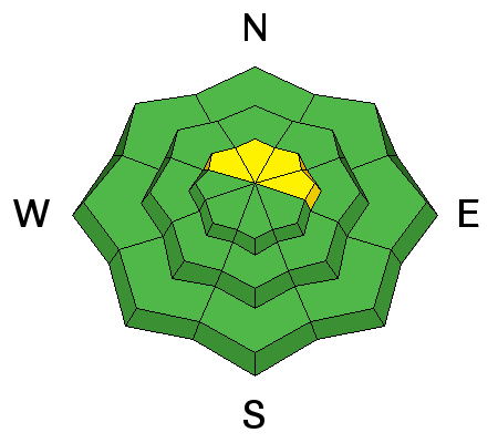
There may be a few fresh wind slabs that form today as new snow falls. With minimal snow available for transport, these wind slabs should be isolated and pretty small. |
 |
weather Another disturbance will descend over northern Utah today bringing cold air and snow. Temperatures should drop a few degrees from where they are this morning an mostly be in the teens and low 20's F. As this disturbance approaches, wind speeds may increase a little, but overall they should continue from the WNW at 10-15 mph with gusts of 20-30 mph. At the highest elevations near 11,000 feet winds should remain strong and average 30-40 mph. Fingers crossed, but another 3-4 inches should fall today. We need every bit of snow we can get. The next chance for snow doesn't arrive until Saturday. |
| general announcements CLICK HERE FOR MORE GENERAL INFO AND FAQ The UAC has new support programs with Outdoor Research and Darn Tough. Support the UAC through your daily shopping. When you shop at Smith's, or online at Outdoor Research, REI, Backcountry.com, Darn Tough, Patagonia, NRS, Amazon, eBay a portion of your purchase will be donated to the FUAC. See our Donate Page for more details on how you can support the UAC when you shop. Benefit the Utah Avalanche Center when you buy or sell on eBay - set the Utah Avalanche Center as a favorite non-profit in your eBay account here and click on eBay gives when you buy or sell. You can choose to have your seller fees donated to the UAC, which doesn't cost you a penny This information does not apply to developed ski areas or highways where avalanche control is normally done. This advisory is from the U.S.D.A. Forest Service, which is solely responsible for its content. This advisory describes general avalanche conditions and local variations always occur. |