25th Annual Black Diamond Fall Fundraising Party
Thursday, September 13; 6:00-10:00 PM; Black Diamond Parking Lot
25th Annual Black Diamond Fall Fundraising Party
Thursday, September 13; 6:00-10:00 PM; Black Diamond Parking Lot
| Advisory: Ogden Area Mountains | Issued by Mark Staples for Thursday - January 25, 2018 - 7:00am |
|---|

|
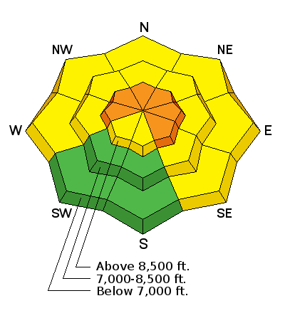
bottom line With strong winds blowing since yesterday afternoon at all elevations, the avalanche danger is CONSIDERABLE at the upper elevations with both wind slab and persistent slab avalanches likely. A MODERATE danger exist at mid and low elevations.
|
 |
special announcement Powder Mountain has their Beacon Training Park up and running near Hidden Lake. Grab your transciever and head over to test your rescue skills! TONIGHT, Fireside Chat at 7 p.m. at Black Diamond. Evelyn Lees discusses avalanche accidents when people were traveling Uphill and/or "Solo" over the past 8 winters. |
 |
current conditions It’s warm and windy this morning with temperatures in the mid to upper 30’s in most areas. Above 9000 ft, temperatures are in the upper 20’s F. Winds are averaging 20-40 mph and gusting to 50 mph from the SSW. On Ogden Peak winds are gusting to 70 mph. |
 |
recent activity Yesterday an Ogden area ski patrol triggered a 50’x50’ avalanche that broke 8-14 inches deep on an E-facing slope that had been cross loaded by S winds. On Monday a skier easily triggered several wind drifts on Cutler Ridge after a brief spike in winds. |
| type | aspect/elevation | characteristics |
|---|

|
|
LIKELIHOOD
 LIKELY
UNLIKELY
SIZE
 LARGE
SMALL
TREND
 INCREASING DANGER
SAME
DECREASING DANGER
|
|
description
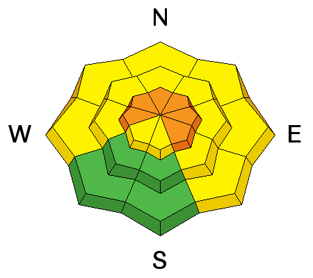
Strong S and SW winds have been blowing since yesterday. Even though many S facing slopes have developed an ice crust on them from the last two days of sunny weather, these strong winds will find snow to transport and form fresh wind slabs. These wind slabs should be easy to trigger today, but they may also make triggering deeper and large avalanches more likely. See below. |
| type | aspect/elevation | characteristics |
|---|

|
|
LIKELIHOOD
LIKELY
UNLIKELY
SIZE
 LARGE
SMALL
TREND
INCREASING DANGER
SAME
DECREASING DANGER
|
|
description
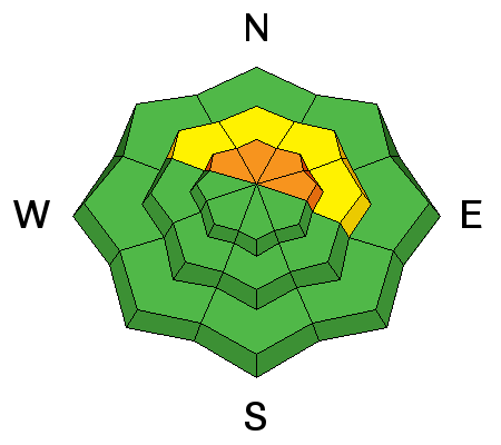
The snowpack, mainly on ones with a northerly aspect at mid and upper elevations, contains weak faceted snow generally above a very hard layer of snow/ice (you'll know when you hit it with your shovel). These faceted layers of weak snow are generally buried 1-3 feet deep depending on elevation. Today's wind's will be cross loading some slopes and top loading others. This wind loading will add stress to these buried faceted layers and make them more likely to fracture and produce an avalanche. |
 |
weather Strong SW winds and warm temperatures will continue until a cold front arrives this afternoon around 2 p.m. It will bring snowfall, decreasing winds and a sharp temperature drop. Temperatures will only rise a few degrees before the cold front arrives. There should be 3-6 inches of snow by tomorrow morning. Temperatures tonight will drop to near 10 degrees F. |
| general announcements CLICK HERE FOR MORE GENERAL INFO AND FAQ The UAC has new support programs with Outdoor Research and Darn Tough. Support the UAC through your daily shopping. When you shop at Smith's, or online at Outdoor Research, REI, Backcountry.com, Darn Tough, Patagonia, NRS, Amazon, eBay a portion of your purchase will be donated to the FUAC. See our Donate Page for more details on how you can support the UAC when you shop. Benefit the Utah Avalanche Center when you buy or sell on eBay - set the Utah Avalanche Center as a favorite non-profit in your eBay account here and click on eBay gives when you buy or sell. You can choose to have your seller fees donated to the UAC, which doesn't cost you a penny This information does not apply to developed ski areas or highways where avalanche control is normally done. This advisory is from the U.S.D.A. Forest Service, which is solely responsible for its content. This advisory describes general avalanche conditions and local variations always occur. |


