25th Annual Black Diamond Fall Fundraising Party
Thursday, September 13; 6:00-10:00 PM; Black Diamond Parking Lot
25th Annual Black Diamond Fall Fundraising Party
Thursday, September 13; 6:00-10:00 PM; Black Diamond Parking Lot
| Advisory: Ogden Area Mountains | Issued by Paige Pagnucco for Wednesday - January 24, 2018 - 5:44am |
|---|

|
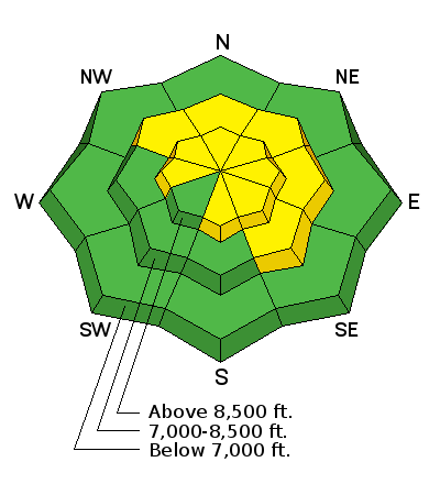
bottom line Winds have created a MODERATE danger for triggering wind slabs along mid and upper elevation ridgelines, which will become more widespread as wind speeds increase throughout the day. The danger for wind slab avalanches could rise to CONSIDERABLE, especially if wind speeds increase sooner in the day and/or are stronger than expected. The avalanche danger is MODERATE on steep, mid and upper elevation slopes facing northerly through easterly. Heightened avalanche conditions exist as human triggered avalanches are possible, and large avalanches can be triggered in isolated places. Avoid steep, north through easterly facing slopes, where it’s most likely to trigger a persistent slab avalanche. Low angle slopes on all aspects have good turning and riding conditions in soft, settled snow.
|
 |
special announcement Powder Mountain has their Beacon Training Park up and running near Hidden Lake. Grab your transciever and head over to test your rescue skills! The UAC has new support programs with Outdoor Research and Darn Tough. Support the UAC through your daily shopping. When you shop at Smith's, or online at Outdoor Research, REI, Backcountry.com, Darn Tough, Patagonia, NRS, Amazon, eBay a portion of your purchase will be donated to the FUAC. See our Donate Page for more details on how you can support the UAC when you shop. We have discount lift tickets for Alta, Snowbird, Brighton, Solitude, Snowbasin,and Beaver Mountain. Details and order information here. All proceeds from these go towards paying for avalanche forecasting and education! |
 |
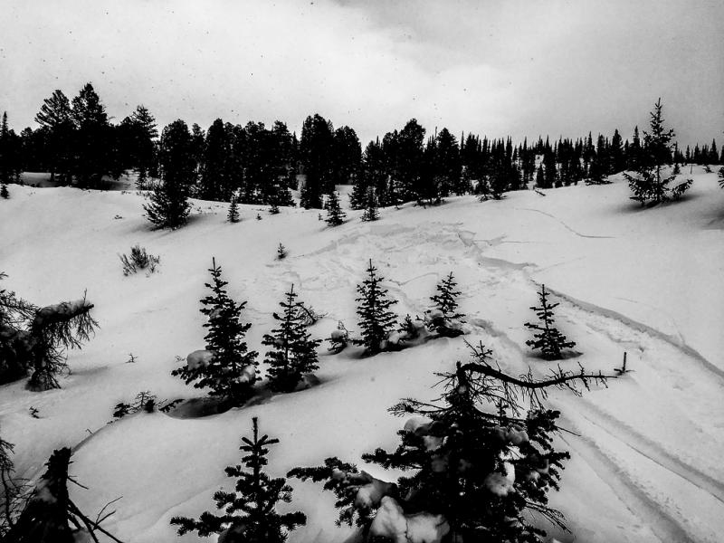
current conditions Temperatures this morning are around 20 F and south-southwest winds are beginning to slowly ramp up in advance of tomorrow's weather system. Current wind speeds are 15-20 mph with gusts in the 30-40 mph range. Wind strength will continue to increase throughout the day - expect ridgelines to be uncomfortable locales to hang out. Last weekend's storm snow, though settled out a bit, is still providing good riding conditions on sheltered, low angle slopes. (pc: Brian Smith)
|
 |
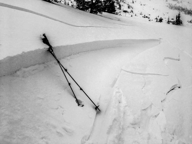
recent activity Slightly stronger winds across Cutler Ridge in the Ogden area mountains quickly whipped up some very sensitive wind drifts on Monday.
|
| type | aspect/elevation | characteristics |
|---|

|

|
LIKELIHOOD
 LIKELY
UNLIKELY
SIZE
 LARGE
SMALL
TREND
 INCREASING DANGER
SAME
DECREASING DANGER
|
|
description
Well at least the increasing winds mean that more snow is on the way. Today though keep an eye out for wind loading on leeward slopes. Southwest winds are expected to increase throughout the day and, with snow available for transport, we'll see wind slabs quickly forming, especially along ridgelines and gullies at high elevations. Avoid steep slopes with freshly drifted snow to avoid this problem. Even a small wind slab avalanche has the potential to step down to a deeper weak layer and create a much larger and more dangerous avalanche. Note: the avalanche danger for wind slab avalanches could rise to Considerable, especially if wind speeds increase sooner in the day and/or are stronger than expected. Cutler Ridge wind slab from Monday. (pc: Doug Wewer)
|
| type | aspect/elevation | characteristics |
|---|

|
|
LIKELIHOOD
LIKELY
UNLIKELY
SIZE
 LARGE
SMALL
TREND
 INCREASING DANGER
SAME
DECREASING DANGER
|
|
description
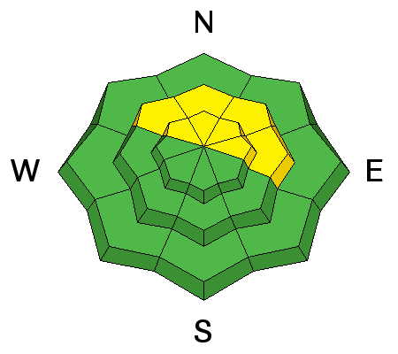
We are certainly all learning the true meaning of persistent this season. While we get nickel and dimed with snowfall amounts, the persistent weak layers present in most of the zone's snowpack are not going anywhere anytime soon. We are still experiencing high variability in stability test results from slope to slope and even pit to pit but the clearly visible poor snowpack structure is still a major red flag. In some areas the weakest snow sits under a slab while, in others, there is a multi-layered crust/facet sandwich. No matter what the setup, it is still possible to trigger an avalanche 1 to 3 feet deep on these buried weak layers, especially on steep, northwest through easterly facing slopes at high and mid elevations. The consequences of getting caught in a slide are high as rocks and stumps are still hardly buried in the unseasonably thin snowpack. Low angle, sheltered terrain still offers the best riding conditions anyway. |
 |
weather Today is forecast to be mostly sunny in the Ogden zone with temperatures rising to 30 - 35 F. The winds will be the big story as speeds increase ahead of tomorrow's storm event. Expect southwest winds to jump up mid to late morning hitting 20-30 mph with ridgelines seeing gusts near 40-50 mph. Winds stay strong as snow arrives mid-morning tomorrow. The Ogden area mountains might get a whopping 2-4" initially as unsetled weather sets up for the next few days. Beggars can't be choosers so any amount of the white stuff is welcome! |
| general announcements CLICK HERE FOR MORE GENERAL INFO AND FAQ Support the UAC through your daily shopping. When you shop at Smith's, or online at REI, Backcountry.com, Patagonia, NRS, Amazon, eBay a portion of your purchase will be donated to the FUAC. See our Donate Page for more details on how you can support the UAC when you shop. Benefit the Utah Avalanche Center when you buy or sell on eBay - set the Utah Avalanche Center as a favorite non-profit in your eBay account here and click on eBay gives when you buy or sell. You can choose to have your seller fees donated to the UAC, which doesn't cost you a penny. This information does not apply to developed ski areas or highways where avalanche control is normally done. This advisory is from the U.S.D.A. Forest Service, which is solely responsible for its content. This advisory describes general avalanche conditions and local variations always occur. |