25th Annual Black Diamond Fall Fundraising Party
Thursday, September 13; 6:00-10:00 PM; Black Diamond Parking Lot
25th Annual Black Diamond Fall Fundraising Party
Thursday, September 13; 6:00-10:00 PM; Black Diamond Parking Lot
| Advisory: Ogden Area Mountains | Issued by Drew Hardesty for Sunday - January 14, 2018 - 7:17am |
|---|

|
bottom line Pockets of CONSIDERABLE danger exist mainly in the upper elevation northerly through easterly aspects. A MODERATE danger exists in the mid-elevation elevation bands. Human triggered sides may be up to 1-2' deep and may be triggered from below. With direct sun and rapid warming, avoid overstaying your welcome on the steep sunny aspects for fear of unstable wet loose avalanching. If you're headed into the backcountry - or exiting though the gates at the ski area - you must have the proper gear, training, and skilled partners. Chance and hope are poor risk management strategies. PSA - Be aware of other parties in the backcountry - you would never would want to accidentally trigger a slide onto a party below - by remotely triggering a slide or kicking a cornice.
|
 |
special avalanche bulletin THE FOREST SERVICE UTAH AVALANCHE CENTER IN SALT LAKE CITY HAS ISSUED A BACKCOUNTRY AVALANCHE SPECIAL BULLETIN. * TIMING…IN EFFECT FROM 9 PM MST FRIDAY TO 9 PM MST MONDAY * AFFECTED AREA…FOR THE MOUNTAINS OF NORTHERN UTAH INCLUDING THE WASATCH RANGE...BEAR RIVER RANGE...UINTA MOUNTAINS. * AVALANCHE DANGER…DANGEROUS HUMAN TRIGGERED AVALANCHES REMAIN LIKELY. * IMPACTS…BEAUTIFUL WEATHER OVER THE HOLIDAY WEEKEND AND RECENT FRESH POWDER SNOW WILL LEAD TO A SIGNIFICANT INCREASE IN PUBLIC USE IN THE MOUNTAINS OF NORTHERN UTAH. SNOWPACK, WEATHER, AND HUMAN CONDITIONS ARE PERFECTLY ALIGNED FOR A POTENTIAL ACCIDENT THIS WEEKEND. MANY SLOPES, ESPECIALLY ONES ABOVE 8000 FT WITH A NORTHERLY THROUGH EASTERLY ASPECT, ONLY NEED A SKIER OR RIDER TO TRIGGER AN AVALANCHE 2-3 FEET DEEP AND SEVERAL HUNDRED FEET WIDE. THIS WARNING DOES NOT APPLY TO SKI AREAS WHERE AVALANCHE HAZARD REDUCTION MEASURES ARE PERFORMED. |
 |
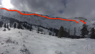
current conditions Skies are clear; mountain temps are in the mid to upper 20s, and winds generally light from the north. Above 8000', riding and travel conditions are fast on Thursday's couple inches of new capped with a thin rime crust. Wind eroded terrain down to the early week rain crust are slippery at best. Upper elevations have 2-3' of total snow. High relative humidity, light wind, and clear skies are perfect weather conditions for another bumper crop of surface hoar developing on the snow surfaces. It's the wintertime equivalent of dew; we call it "loud powder" and is fun to ski and ride through, but is problematic for the avalanche conditions once buried. (Bo Torrey pic below). The southerly aspects went off (became damp) yesterday, but again the riding conditions remain quite good in the sun and wind sheltered terrain above 8000'. On another note, it sure seems like the future is now. High rain/snow lines from last Monday/Tuesday (up to 9000' give or take) and just looking around at the general coverage brings us to Leigh Sturges and John Horel's work in 2010, Assessing the sensitivity of Wasatch snowfall to temperature variations. (This was her master's work "while she was a pro observer for the UAC".) The image below from Steenburgh's Secrets of the Greatest Snow on Earth shows the work in a nutshell. Evelyn, too, well described the elevation-dependent snow years ago in an annual report - "It's as if a child had frosted a cake and had forgotten about the sides." Pic looking south along the Ogden skyline on Friday.
|
 |
recent activity There were no reports of avalanches from the backcountry yesterday. We did hear of a very close call in the UIntas and some other details of avalanches in the Logan mountains and hope to hear more about this today. I'm sure there were others. Improved visibility allowed observers to note the signicant avalanche cycle along the Ben Lomond to Willard Peak headwall from earlier in the week. Hardesty/Brandt photos. Observations here and here.
|
| type | aspect/elevation | characteristics |
|---|

|
|
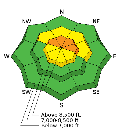
LIKELIHOOD
 LIKELY
UNLIKELY
SIZE
 LARGE
SMALL
TREND
 INCREASING DANGER
SAME
DECREASING DANGER
|
|
description
A poor snowpack structure exists above about 8300' and most pronounced on the northerly through easterly aspects. Cracking, collapsing, snow tests and recent explosive control work offer testimony to areas of unstable snow. Careful snowpack evaluation and cautious route-finding is required. |
 |
weather Bluebird high. Temps will rise to near freezing along the high ridgelines; wind will be light from the northwest. A weakening "sacrificial trough' moves through Tuesday afternoon to batter down the rebuilt ridge before a larger, colder, more hopeful Pacific winter storm engulfs the state on Friday. More info on our Mountain Weather page, updated by noon. |
| general announcements CLICK HERE FOR MORE GENERAL INFO AND FAQ Support the UAC through your daily shopping. When you shop at Smith's, or online at REI, Backcountry.com, Patagonia, NRS, Amazon, eBay a portion of your purchase will be donated to the FUAC. See our Donate Page for more details on how you can support the UAC when you shop. Benefit the Utah Avalanche Center when you buy or sell on eBay - set the Utah Avalanche Center as a favorite non-profit in your eBay account here and click on eBay gives when you buy or sell. You can choose to have your seller fees donated to the UAC, which doesn't cost you a penny. This information does not apply to developed ski areas or highways where avalanche control is normally done. This advisory is from the U.S.D.A. Forest Service, which is solely responsible for its content. This advisory describes general avalanche conditions and local variations always occur. |