25th Annual Black Diamond Fall Fundraising Party
Thursday, September 13; 6:00-10:00 PM; Black Diamond Parking Lot

25th Annual Black Diamond Fall Fundraising Party
Thursday, September 13; 6:00-10:00 PM; Black Diamond Parking Lot
| Advisory: Ogden Area Mountains | Issued by Evelyn Lees for Wednesday - January 10, 2018 - 7:31am |
|---|
 |
avalanche warning THE FOREST SERVICE UTAH AVALANCHE CENTER IN SALT LAKE CITY HAS ISSUED A BACKCOUNTRY AVALANCHE WARNING. * TIMING…IN EFFECT FROM 6 AM MST THIS MORNING TO 6 AM MST THURSDAY * AFFECTED AREA…FOR THE MOUNTAINS OF NORTHERN UTAH INCLUDING THE WASATCH RANGE...PROVO AREA MOUNTAINS...BEAR RIVER RANGE...WESTERN UINTA MOUNTAINS... * AVALANCHE DANGER…THE AVALANCHE DANGER IS HIGH. * IMPACTS…HEAVY SNOW HAS OVERLOADED THE PREEXISTING WEAK SNOW PACK. THE AVALANCHE DANGER IS HIGH AND BOTH HUMAN TRIGGERED AND NATURAL AVALANCHES ARE LIKELY. TRAVEL IN AVALANCHE TERRAIN IS NOT RECOMMENDED. AVALANCHES CAN BE TRIGGERED FROM A DISTANCE AND FROM BELOW. STAY OFF OF AND OUT FROM UNDER SLOPES STEEPER THAN 30 DEGREES. BACKCOUNTRY TRAVELERS SHOULD CONSULT WWW.UTAHAVALANCHECENTER.ORG OR CALL 1-888-999-4019 FOR MORE DETAILED INFORMATION. THIS WARNING DOES NOT APPLY TO SKI AREAS WHERE AVALANCHE HAZARD REDUCTION MEASURES ARE PERFORMED. |
 |
current conditions The cold front is just hitting the Ogden area mountains as I type this…but ahead of the cooler air, it was another warm, soggy night, with light rain and snow falling, and the rain/snow line still hovering around 7,500 to 7,800. Temperatures have been in the low to upper 30s at the lower and mid elevations, cooling into the 20s at the upper elevations. Winds are still from the southwest, and were quiet overnight, but are ramping up with the frontal passage, with speeds of 50, gusting in the 60s on Mt. Ogden. Speeds should increase at the mid elevations, too. Another 3 to 5” of dense snow fell overnight at the upper elevations, with more rain at the lower elevations. Storm totals in the Ogden area mountains are now about 6", with an inch of water. Ben Lomond Peak snotel is the exception, going for trophy amounts of over 3.5" of water. |
 |
recent activity In the Ogden area mountains, resorts reported both skier and explosive triggered slides, with the mid elevations included in the avalanche activity. Wet loose sluffs at the lower elevations. Two days ago, there were large remote avalanches triggered in the Ogden area mountains. Similar slides in the Salt Lake area mountains show what can happen anywhere in the northern Utah mountains - Yesterday, a party on the ridgeline above Meadow Chutes, Silver Fork, remotely triggered a long running slide – about a foot deep, 100’ wide, that ran over 1000’ vertical; avalanche reduction work at the resorts triggered new snow slides with ski cuts, up to a foot deep and large enough to bury a person. Meadow Chutes avalanche photos - Nathan Chaszeyka
|
| type | aspect/elevation | characteristics |
|---|


|


|

LIKELIHOOD
 LIKELY
UNLIKELY
SIZE
 LARGE
SMALL
TREND
 INCREASING DANGER
SAME
DECREASING DANGER
|
|
description
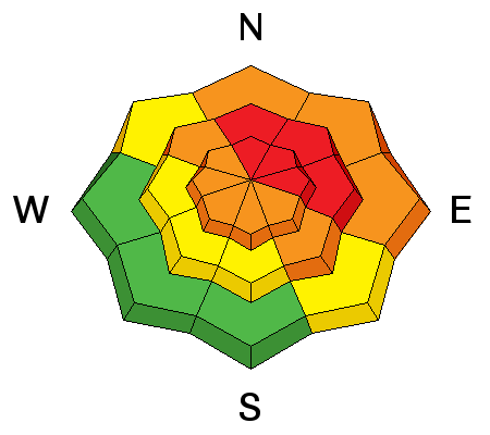
We now have a slab over the patchwork of persistent weak layers – the multiple layers of sugary facets and crusts. Some slopes will avalanche naturally, but many slopes are hanging in balance, just waiting for a trigger. Don’t let it be you. Avalanches can be triggered remotely and from below. Any slide you trigger on a steep slope today will be large enough to take you for a ride and bury you. An avalanche staring in the new storm snow may step down deeper weak layers, and be very long running as it entrains snow down the slope. There may be cement like wet debris if the slide runs down into the mid elevations. |
| type | aspect/elevation | characteristics |
|---|


|


|

LIKELIHOOD
 LIKELY
UNLIKELY
SIZE
 LARGE
SMALL
TREND
 INCREASING DANGER
SAME
DECREASING DANGER
|
|
description
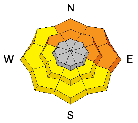
Over 24 hours of rain and wet snow has created at soggy snow pack below about 8,500’, and both natural and human triggered wet loose sluffs and wet slab avalanches are possible. Anywhere there is snow down low, avoid steep terrain, including even small features such as creek beds, road banks and gullies. |
| type | aspect/elevation | characteristics |
|---|


|


|

LIKELIHOOD
 LIKELY
UNLIKELY
SIZE
 LARGE
SMALL
TREND
 INCREASING DANGER
SAME
DECREASING DANGER
|
|
description
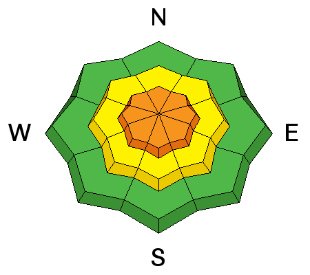
Winds are forecast to increase with frontal passage, and will drift snow at the higher and mid elevations, overloading the weak layers in the snowpack. Any period of strong winds is when natural avalanches may occur |
 |
weather The cold front is just reaching the Ogden area mountains. An additional 3 to 8” of snow is possible by evening. Winds will shift to the northwest and increase with frontal passage – 15 to 25 mph averages, gusting to 25 mph. The highest terrain will have averages to 50 mph, with gusts in the 60s. A few lingering snow showers tonight, with temperatures finally cooling – into the teens. The northwesterly winds will decrease overnight. |
| general announcements CLICK HERE FOR MORE GENERAL INFO AND FAQ Support the UAC through your daily shopping. When you shop at Smith's, or online at REI, Backcountry.com, Patagonia, NRS, Amazon, eBay a portion of your purchase will be donated to the FUAC. See our Donate Page for more details on how you can support the UAC when you shop. Benefit the Utah Avalanche Center when you buy or sell on eBay - set the Utah Avalanche Center as a favorite non-profit in your eBay account here and click on eBay gives when you buy or sell. You can choose to have your seller fees donated to the UAC, which doesn't cost you a penny. This information does not apply to developed ski areas or highways where avalanche control is normally done. This advisory is from the U.S.D.A. Forest Service, which is solely responsible for its content. This advisory describes general avalanche conditions and local variations always occur. |