25th Annual Black Diamond Fall Fundraising Party
Thursday, September 13; 6:00-10:00 PM; Black Diamond Parking Lot
25th Annual Black Diamond Fall Fundraising Party
Thursday, September 13; 6:00-10:00 PM; Black Diamond Parking Lot
| Advisory: Ogden Area Mountains | Issued by Greg Gagne for Monday - January 8, 2018 - 7:10am |
|---|


|
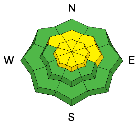
bottom line The overall avalanche hazard is MODERATE where pockets of fresh wind drifts can be found primarily at the upper elevations. With increasing winds today, I am expecting this hazard to increase, including drifting down off of ridgelines. There also is a MODERATE hazard of a persistent slab avalanche on slopes facing north through east, failing in a deeper layer of the snowpack. You may also find minor wet, loose activity at lower elevations as well as aspects facing south and west On lower-angled slopes, as well as slopes that aren't wind loaded, the hazard is LOW. We expect a rising avalanche hazard this week, with potentially dangerous conditions by midweek.
|
 |
special announcement We have discount lift tickets for Alta, Snowbird, Brighton, Solitude, Deer Valley, Snowbasin,and Beaver Mountain. Details and order information here. All proceeds from these go towards paying for avalanche forecasting and education! |
 |
current conditions As of 6 am, temperatures in the Ogden mountains are in the upper 20's and low 30's F. The increasing winds are the highlight, where gusts are now over 50 mph on Ogden Peak, and gusting into the 20's and 30's mph at other stations. The general consensus is that riding conditions have greatly improved with the small, 3-5" storm from Saturday, although low elevations are still quite brushy. |
 |
recent activity Only minor avalanches were reported from the Ogden mountains, mostly consisting of small amounts of storm snow. We received three excellent observations on Sunday from Ogden area observers, highlighted by Doug Wewer's report of a reported a large collapse on an east-facing aspect at 8000' on Cutler Ridge. |
| type | aspect/elevation | characteristics |
|---|

|
|
LIKELIHOOD
 LIKELY
UNLIKELY
SIZE
 LARGE
SMALL
TREND
 INCREASING DANGER
SAME
DECREASING DANGER
|
|
description
Increasing winds out of the southwest will drift mid and upper elevations today. Some of these fresh wind slabs will be drifted on top of weaker faceted snow where they may be especially sensitive. In Doug Wewer's observation, he keenly noticed the collapse of a fresh wind slab on top of faceted snow was "the only piece of bull's eye data I needed for today. I kept slope angles low and avoided being below steep slopes. " |
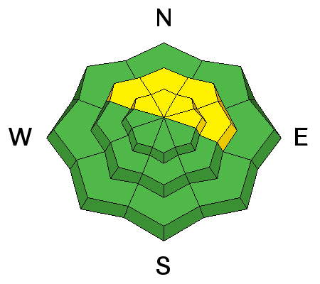
| type | aspect/elevation | characteristics |
|---|

|
|
LIKELIHOOD
 LIKELY
UNLIKELY
SIZE
LARGE
SMALL
TREND
INCREASING DANGER
SAME
DECREASING DANGER
|
|
description
The snowpack at mid and upper elevations facing northwest through east are plagued with weaknesses from the ground, to the old snow surface sitting just below the Saturday storm snow. Overall the small Saturday storm wasn't enough of a load to affect deeper layers. One observation from Sunday noted moist snow and rain from Saturday may have destroyed the weaker faceted snow at the old snow surface at some mid elevations. With snow and wind in the forecast, this persistent slab avalanche problem will become increasingly hazardous as this week progresses. |
 |
weather Good news! A much-needed period of precipitation is on its way! Cloudy with increasing winds out of the south and west with gusts into the 30's and 40's mph, and locally higher (i.e. Mt. Ogden). Temperatures will warm into the 30's. Precipitation should hold off until the evening hours, with a high rain/snow line (perhaps to 8000') and several inches of dense snow overnight on a southwest flow. Currently this storm system looks to be a very equitable producer, with initially a southwest flow through Tuesday, followed by a colder northwest flow on Wednesday and into Thursday. |
| general announcements CLICK HERE FOR MORE GENERAL INFO AND FAQ Support the UAC through your daily shopping. When you shop at Smith's, or online at REI, Backcountry.com, Patagonia, NRS, Amazon, eBay a portion of your purchase will be donated to the FUAC. See our Donate Page for more details on how you can support the UAC when you shop. Benefit the Utah Avalanche Center when you buy or sell on eBay - set the Utah Avalanche Center as a favorite non-profit in your eBay account here and click on eBay gives when you buy or sell. You can choose to have your seller fees donated to the UAC, which doesn't cost you a penny. This information does not apply to developed ski areas or highways where avalanche control is normally done. This advisory is from the U.S.D.A. Forest Service, which is solely responsible for its content. This advisory describes general avalanche conditions and local variations always occur. |


