25th Annual Black Diamond Fall Fundraising Party
Thursday, September 13; 6:00-10:00 PM; Black Diamond Parking Lot
25th Annual Black Diamond Fall Fundraising Party
Thursday, September 13; 6:00-10:00 PM; Black Diamond Parking Lot
| Advisory: Ogden Area Mountains | Issued by Mark Staples for Sunday - January 7, 2018 - 5:44am |
|---|

|
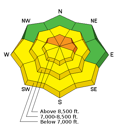
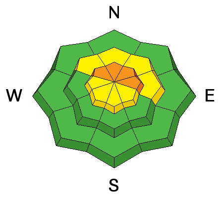
bottom line The new snow should create shallow avalanches in many areas today. Northerly facing slopes above 8000 feet with 5 inches of snow or more could have larger avalanches break 2-3 feet deep. The potential for these slides creates dangerous avalanche conditions and the danger is CONSIDERABLE upper elevation slopes. A MODERATE danger exists on mid and lower elevation slopes and ones with a southerly aspect.
|
 |
special announcement We have discount lift tickets for Alta, Snowbird, Brighton, Solitude, Deer Valley, Snowbasin,and Beaver Mountain. Details and order information here. All proceeds from these go towards paying for avalanche forecasting and education! |
 |
current conditions Since yesterday morning 3-5 inches of snow (11% denisty) fell in the Ogden area mountains. This dense snow contains 0.4-0.6 inches of water. This morning temperatures are near 20 degrees F at 9000 ft and near freezing at lower elevations near 6000 feet. Winds are surprisingly light this morning and are blowing 5 mph gusting to 10 mph from the W. Slightly stronger winds blew yesterday afternoon from the SW and NW at 10 mph with gusts of 20 mph. Because yesterday's snow was relatively warm and dense, these winds were probably not strong enough to transport much new snow. |
 |
recent activity There has been no recently reported avalanche activity. |
| type | aspect/elevation | characteristics |
|---|

|
|
LIKELIHOOD
 LIKELY
UNLIKELY
SIZE
 LARGE
SMALL
TREND
 INCREASING DANGER
SAME
DECREASING DANGER
|
|
description
Prior to yesterday's storm the snow surface on many slopes became weak and faceted on most slopes other than ones facing SW, S, and SE. The 3-4 inches of new snow resting on these facets should be easy to trigger today where rest on this faceted layer. While not particularly dangerous being only a few inches deep, these slides should occur in many areas. The old snow surface on other slopes was a mix of ice crusts, wind slabs, and other surfaces that were not weak. The new snow arrived wet and will likely bond well to these old surfaces. Larger avalanches are possible in some places that received 5 inches of snow containing 0.6 inches of water. There is a generally a very hard ice crust about 6-12 inches above the ground on upper elevations slopes facing the northern half of the compass. Weak facets just above this crust could fracture and produce deeper and more dangerous slides. |
| type | aspect/elevation | characteristics |
|---|

|
|
LIKELIHOOD
 LIKELY
UNLIKELY
SIZE
 LARGE
SMALL
TREND
 INCREASING DANGER
SAME
DECREASING DANGER
|
|
description
Warm temperatures and sunshine today should dampen the snow on southerly aspects. In many places the new snow rests on an ice crust. As the snow gets wet, there may some small, wet loose avalanches today on these aspects but shouldn't be a major concern and will occur predictably as the day warms. |
 |
weather Clouds and fog will slowly dissipate this morning as another ridge of high pressure builds and brings clear skies and sunshine by this afternoon. Temperatures should reach the mid 30's F later today and winds will remain light. The good news is that this ridge of high pressure will be short lived as a minor trough of low pressure arrives Monday night with a few inches of snow. A larger trough of low pressure follows the smaller one and arrives Tuesday night. . |
| general announcements CLICK HERE FOR MORE GENERAL INFO AND FAQ To get help in an emergency (to request a rescue) in the Wasatch, call 911. Be prepared to give your GPS coordinates. Backcountry Emergencies. It outlines your step-by-step method in the event of a winter backcountry incident. If you trigger an avalanche in the backcountry, but no one is hurt and you do not need assistance, please notify the nearest ski area dispatch to avoid a needless response by rescue teams. Thanks.
This information does not apply to developed ski areas or highways where avalanche control is normally done. This advisory is from the U.S.D.A. Forest Service, which is solely responsible for its content. This advisory describes general avalanche conditions and local variations always occur. |


