25th Annual Black Diamond Fall Fundraising Party
Thursday, September 13; 6:00-10:00 PM; Black Diamond Parking Lot
25th Annual Black Diamond Fall Fundraising Party
Thursday, September 13; 6:00-10:00 PM; Black Diamond Parking Lot
| Advisory: Ogden Area Mountains | Issued by Mark Staples for Saturday - January 6, 2018 - 6:25am |
|---|

|
bottom line Avalanche conditions are generally safe and the avalanche danger is LOW. The snowpack is generally very weak, but is not unstable because it doesn't have stress from new snow. Today's snowfall of only a few inches shouldn't add enough stress to change the situation, but watch out if more than a few inches of snow fall by this afternoon which could raise the danger.
|
 |
special announcement Spend some time improving your rescue skills or learning about avalanches in these two, upcoming Ogden area classes: January 12, 2018 Companion Rescue Fundamentals Snowbasin January 18, 2018 Backcountry 101 Avalanche Class Snowbasin Episode 2 of the UAC podcast has been released. Drew Hardesty talks Avalanche Weather with Professor Powder himself, atmospheric sciences professor and author of Secrets of the Greatest Snow on Earth, Jim Steenburgh. Check it out on ITunes, Stitcher, the UAC blog, or wherever you get your podcasts. |
 |
current conditions This morning in the Ogden area mountains, temperatures area few degrees either side of freezing. At 9000 feet, ridge top wind are blowing 15 mph gusting to 20 mph from the SSW. Winds are light below ridgetops. Skies are cloudy with a minor storm approaching. Overall snow depths are 2-3 feet deep on upper elevation, north facing slopes. South facing slopes barely have enough snow to ride. Slopes that have not received direct sunshine, have been weakening and faceting on the snow surface. This process makes the snow surface seem "powdery" when it hasn't snowed in while because the snow crystals are faceting and losing cohesion. South aspects have gotten damp during the day and refrozen at night. |
 |
recent activity There has been no recently reported avalanche activity. |
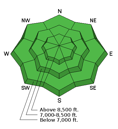
| type | aspect/elevation | characteristics |
|---|

|
|
LIKELIHOOD
 LIKELY
UNLIKELY
SIZE
 LARGE
SMALL
TREND
 INCREASING DANGER
SAME
DECREASING DANGER
|
|
description
A low danger means that avalanche conditions are generally safe, but some unstable snow is possible on isolated terrain features. Watch out if more than a few inches of snow accumulates by later this afternoon. With the still generally shallow snowpack, even a short ride in an avalanche could be painful as rocks and stumps linger near the surface.
|
 |
weather Today's weak storm will bring snow late this morning through this afternoon and bring 1-3 inches of snow with another inch or so tonight. Winds today will remain about 10 mph with gusts of 15-20 mph. They will shift from the SW to W during the day. Temperatures should rise into the upper 30's F. High pressure with clear, sunny weather returns Sunday through Tuesday. A better chance for more snow will come with a storm that arrives sometime Tuesday. |
| general announcements CLICK HERE FOR MORE GENERAL INFO AND FAQ To get help in an emergency (to request a rescue) in the Wasatch, call 911. Be prepared to give your GPS coordinates. Backcountry Emergencies. It outlines your step-by-step method in the event of a winter backcountry incident. If you trigger an avalanche in the backcountry, but no one is hurt and you do not need assistance, please notify the nearest ski area dispatch to avoid a needless response by rescue teams. Thanks.
This information does not apply to developed ski areas or highways where avalanche control is normally done. This advisory is from the U.S.D.A. Forest Service, which is solely responsible for its content. This advisory describes general avalanche conditions and local variations always occur. |


