25th Annual Black Diamond Fall Fundraising Party
Thursday, September 13; 6:00-10:00 PM; Black Diamond Parking Lot
25th Annual Black Diamond Fall Fundraising Party
Thursday, September 13; 6:00-10:00 PM; Black Diamond Parking Lot
| Advisory: Ogden Area Mountains | Issued by Drew Hardesty for Wednesday - January 3, 2018 - 7:04am |
|---|

|
bottom line A MODERATE danger exists on steep mid and upper elevation northerly through easterly facing slopes. Human triggered slides 1-2' deep and 200' wide remain possible and may still be triggered from adjacent terrain or below. Be particularly alert to stiff and stubborn wind drifts in the open exposed terrain. The safest and arguably best riding conditions remain on low angle terrain on the sheltered shady slopes.
|
 |
special announcement Spend some time improving your rescue skills or learning about avalanches in these two, upcoming Ogden area classes: January 12, 2018 Companion Rescue Fundamentals Snowbasin January 18, 2018 Backcountry 101 Avalanche Class Snowbasin |
 |
current conditions High thin clouds are filtering through overhead. We keep waiting, looking off to the west for some sign of winter. There may be a mirage on the horizon for late weekend. We'll see. In the meantime, mountain temperatures are in the low 30s; winds are hardly a whisper. Snow depths sit at 2-3'. |
 |
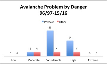
recent activity It has been several days since any new avalanche activity has been reported though there were some close calls after the Christmas storm. See the avalanche list here. Recent Ogden area mountain observations are here. For perspective, it's worth noting the numbers and types of avalanches involved in avalanche fatalities since the winter of 1996/1997. (This was the winter Considerable was added to the danger scale). Those that perceive 'Moderate as the new Low' may be surprised at the numbers. P/D (in blue) are Persistent and Deep Slab avalanches. For moderate danger anyway, you'll see that these two account for half of the fatalities while accounting for only two-ninths of the stable of avalanche problems. For more info on the avalanche problems, check out the Avalanche Problem Toolbox.
|
| type | aspect/elevation | characteristics |
|---|

|
|
LIKELIHOOD
 LIKELY
UNLIKELY
SIZE
 LARGE
SMALL
TREND
 INCREASING DANGER
SAME
DECREASING DANGER
|
|
description
Observers still reported minor collapsing yesterday, though test pits in the snow now offer inconsistent, if conflicting results. We're on the back end of the curve with slowly increasing stability. The operative word being slow. Whereas many slopes would avalanche last week, now perhaps only a few would. Unlike for other types of avalanche problems, ski cuts, cornice drops, and test pits can be unreliable pieces of information for persistent slab avalanches: use them to mark a slope as suspect, but not the other way around. |
 |
weather We'll have mostly sunny skies with mild temperatures and light wind. Temps will flirt with freezing along the ridgetops with 5-10mph winds from the west and southwest. Some semblance of a storm looks to move through later Saturday, though the weather models struggle to agree on a solution at this time. Stay tuned. |
| general announcements CLICK HERE FOR MORE GENERAL INFO AND FAQ To get help in an emergency (to request a rescue) in the Wasatch, call 911. Be prepared to give your GPS coordinates. Backcountry Emergencies. It outlines your step-by-step method in the event of a winter backcountry incident. If you trigger an avalanche in the backcountry, but no one is hurt and you do not need assistance, please notify the nearest ski area dispatch to avoid a needless response by rescue teams. Thanks.
This information does not apply to developed ski areas or highways where avalanche control is normally done. This advisory is from the U.S.D.A. Forest Service, which is solely responsible for its content. This advisory describes general avalanche conditions and local variations always occur. |