25th Annual Black Diamond Fall Fundraising Party
Thursday, September 13; 6:00-10:00 PM; Black Diamond Parking Lot
25th Annual Black Diamond Fall Fundraising Party
Thursday, September 13; 6:00-10:00 PM; Black Diamond Parking Lot
| Advisory: Ogden Area Mountains | Issued by Mark Staples for Saturday - December 30, 2017 - 7:07am |
|---|


|
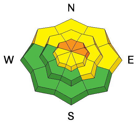
bottom line Dangerous avalanche conditions exist on upper elevation slopes facing NW, N, NE, and E where the danger is CONSIDERABLE and persistent slab avalanches will break on buried faceted layers. These are slopes with the most snow and best riding conditions, so the best strategy is to simply stick to low angle slopes and avoid being under steeper slopes. Other slopes at low and mid elevations and other aspects have a MODERATE danger. South and West aspects have minimal snow cover and a LOW danger.
|
 |
current conditions This morning temperatures are generally in the 40's F with temperatures near 9000 feet in elevation in the mid 30's F. Winds are averaging 15-20 mph with gusts of 30 mph from the SW. Sunny or southerly facing slopes have been cooked and have become wet each day. Northerly facing and shaded slopes still have dry snow which may seem more powdery because the surface snow has started to weaken and facet a little bit. |
 |
recent activity Collapsing continues to occur as Greg and Evelyn found yesterday on a few northerly facing slopes as they looked at a few places in northern Ogden Valley. Collapsing is just as much of a red flag as recent avalanches. It is the same process that creates an avalanche except that it occurs on a lower angle slope and the slab does not release. Following two storms around Christmas, there were many avalanches and observations of instability this week. |
| type | aspect/elevation | characteristics |
|---|

|
|
LIKELIHOOD
 LIKELY
UNLIKELY
SIZE
 LARGE
SMALL
TREND
 INCREASING DANGER
SAME
DECREASING DANGER
|
|
description
It's been almost a week since the first of two storms overloaded the snowpack, yet persistent slab avalanches remain a problem. The exact nature of this avalanche problem is that it persists and doesn't go away. The general structure of the snowpack on slopes where most of these avalanches have occurred can be simplified into three basic layers. More layers exists but these are the most obvious ones to see.
These layers provide all the ingredients for a slab avalanche. All that's missing is a trigger and a steep slope. HEADS UP - Increased winds today will find some snow to transport. Evelyn and Greg observed some fresh wind loading yesterday. This wind loading will mainly be a problem because the extra weight on slopes will keep buried faceted layers near their breaking point. |
 |
weather Temperatures today should warm into the upper 40's F before a weak cold front brings clouds, increased winds, and just an inch or two of snow. Winds will blow mostly westerly at 15-25 mph with gusts of 45 mph. An inch or two may fall tonight as well if we're lucky. Another ridge of high pressure will begin building over Utah and bring dry and warm weather for next week. |
| general announcements FOR MORE GENERAL INFORMATION AND FAQ, CLICK HERE Support the UAC through your daily shopping. When you shop at Smith's, or online at REI, Backcountry.com, Patagonia, NRS, Amazon, eBay a portion of your purchase will be donated to the FUAC. See our Donate Page for more details on how you can support the UAC when you shop. Benefit the Utah Avalanche Center when you buy or sell on eBay - set the Utah Avalanche Center as a favorite non-profit in your eBay account here and click on eBay gives when you buy or sell. You can choose to have your seller fees donated to the UAC, which doesn't cost you a penny This information does not apply to developed ski areas or highways where avalanche control is normally done. This advisory is from the U.S.D.A. Forest Service, which is solely responsible for its content. This advisory describes general avalanche conditions and local variations always occur. |


