25th Annual Black Diamond Fall Fundraising Party
Thursday, September 13; 6:00-10:00 PM; Black Diamond Parking Lot
25th Annual Black Diamond Fall Fundraising Party
Thursday, September 13; 6:00-10:00 PM; Black Diamond Parking Lot
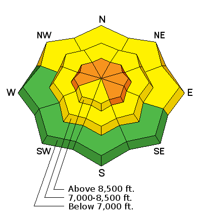
| Advisory: Ogden Area Mountains | Issued by Paige Pagnucco for Friday - December 29, 2017 - 5:58am |
|---|

|
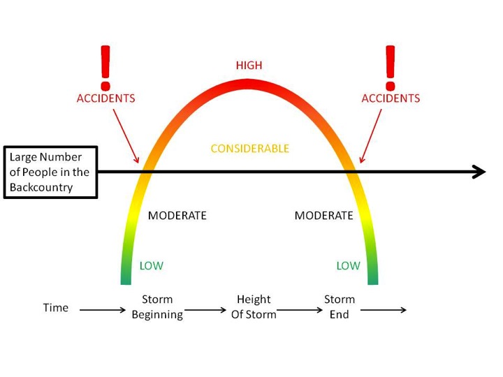
bottom line There is a CONSIDERABLE avalanche danger on many slopes in the backcountry. Dangerous avalanche conditions exist - careful snowpack evaluation, cautious route finding and conservative decision making are essential to your survival in the backcountry today. Human-triggered avalanches can be triggered remotely from a distance as well as from below. Choose to travel on flat terrain or low angle slopes not connected to steeper terrain above. *Remember that when you leave a ski area boundary, you are entering the backcountry. You should travel with avalanche rescue gear as well as understand the avalanche hazard. We are still in the period of time where avalanche accidents are likely - traveling in safe terrain will keep you from becoming a statistic.
|
 |
current conditions Skies are mostly clear with temps in the low to mid 30's F with moderate southwest winds. Upper elevation snowpack depths sit at two to almost three feet. Riding conditions are quite good as the Christmas storm snow settles, but still a touch thin at low elevations.
A big shout out to LUCKY SLICE PIZZA in Ogden for bringing a ton of awesome pizza to Wednesday's KNOW BEFORE YOU GO talk at GEAR 30. We appreciate your support and love your pizza! If you are interested in furthering your avalanche education, visit our EDUCATION page. |
 |
recent activity Observers are still experiencing collapsing - strong evidence of continued poor snowpack structure. The week was filled with avalanches and observations of instability: On Wednesday there was a remotely triggered avalanche on Beer Hill in the Monte Cristo area. A snowmobiler triggered the avalanche from about 150 yards away. Read the observation here.
Mark Staples visited Whiskey Hill Wednesday to conduct an investigation of Tuesday's accident involving multiple burials. See photo below and read his thorough report here.
An avalanche cycle occurred just prior to Christmas Day and many slopes may still yet be triggered by backcountry travelers on and adjacent to steep slopes. Plenty of excellent recent observations from Ogden to read. |
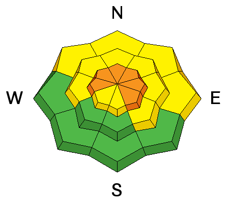
| type | aspect/elevation | characteristics |
|---|

|
|
LIKELIHOOD
 LIKELY
UNLIKELY
SIZE
 LARGE
SMALL
TREND
 INCREASING DANGER
SAME
DECREASING DANGER
|
|
description
Though this type of avalanche is getting harder to trigger, the consequences of getting caught in one remain high. The snow is SLOWLY stabilizing but we still have collapsing and recent avalanches - RED FLAGS for avalanche activity. Persistent = continuing to exist or endure over a prolonged period. This weak layer is not going anywhere anytime soon so, until we see evidence of stabilization, continue to stay on low angle terrain and out from under steep slopes. See Mark's video from Whiskey Hill as he explains why it is so easy to trigger an avalanche from below. |
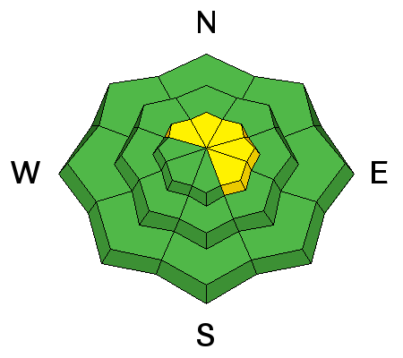
| type | aspect/elevation | characteristics |
|---|

|
|
LIKELIHOOD
 LIKELY
UNLIKELY
SIZE
LARGE
SMALL
TREND
INCREASING DANGER
SAME
DECREASING DANGER
|
|
description
Moderate southwesterly winds continue to drift snow near ridge lines and terrain features like gullies. Wind slabs look smooth and feel chalky and hollow. If triggered, this type of slide could step down to one of the deeper weak layers, resulting in a much larger avalanche. Avoid steep wind drifted slopes to avoid this problem. |
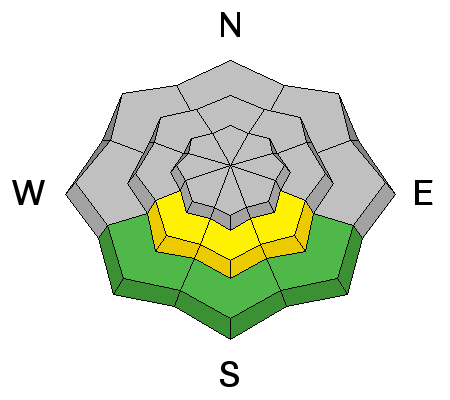
| type | aspect/elevation | characteristics |
|---|

|
|
LIKELIHOOD
LIKELY
UNLIKELY
SIZE
 LARGE
SMALL
TREND
INCREASING DANGER
SAME
DECREASING DANGER
|
|
description
With warm overnight temperatures and forecasted high temperatures nearing 40 F in the mountains there's a small chance for wet activity on sun-drenched sheltered south facing slopes though the low sun angle and wind may keep things in check. If the snow gets sticky or you start seeing rollerballs, move to lower angle or shaded terrain. |
 |
weather Today will be partly cloudy in the Ogden area mountains with temperatures nearing 40 F and winds out of the southwest at 10-15 mph, ridgetops closer to 20-25 mph. A quick hitting storm is on tap for tomorrow afternoon with the potential for a few inches of snow. After that, we dry out and wait for another pattern shift. |
| general announcements FOR MORE GENERAL INFORMATION AND FAQ, CLICK HERE Support the UAC through your daily shopping. When you shop at Smith's, or online at REI, Backcountry.com, Patagonia, NRS, Amazon, eBay a portion of your purchase will be donated to the FUAC. See our Donate Page for more details on how you can support the UAC when you shop. Benefit the Utah Avalanche Center when you buy or sell on eBay - set the Utah Avalanche Center as a favorite non-profit in your eBay account here and click on eBay gives when you buy or sell. You can choose to have your seller fees donated to the UAC, which doesn't cost you a penny This information does not apply to developed ski areas or highways where avalanche control is normally done. This advisory is from the U.S.D.A. Forest Service, which is solely responsible for its content. This advisory describes general avalanche conditions and local variations always occur. |


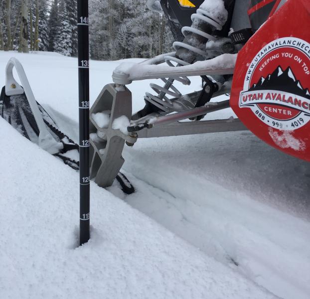
 Beer Hill avalanche 12/27/17
 Whiskey Hill avalanche 12/26/17