25th Annual Black Diamond Fall Fundraising Party
Thursday, September 13; 6:00-10:00 PM; Black Diamond Parking Lot
25th Annual Black Diamond Fall Fundraising Party
Thursday, September 13; 6:00-10:00 PM; Black Diamond Parking Lot
| Advisory: Ogden Area Mountains | Issued by Evelyn Lees for Tuesday - December 26, 2017 - 7:35am |
|---|

|
bottom line AVALANCHE WARNING - The avalanche danger is HIGH today – backcountry travel in avalanche terrain is not recommended. Natural and human triggered avalanches are likely at the upper and mid elevations on northwest through easterly facing slopes. Avalanches can be triggered remotely from a distance and from below. Avoid travel on and below all steep slopes, including even the smaller, steep gullies, creek beds and road banks at the lower elevations. Avoid avalanche terrain by heading to slopes less steep about 30 degrees, which are not adjacent to or below steeper terrain, such as meadows and rolling, low angle terrain
|
 |
avalanche warning THE FOREST SERVICE UTAH AVALANCHE CENTER IN SALT LAKE CITY HAS CONTINUED THE BACKCOUNTRY AVALANCHE WARNING. * TIMING…IN EFFECT FROM 6 AM MST THIS MORNING TO 6 AM MST WEDNESDAY MORNING * AFFECTED AREA…FOR THE MOUNTAINS OF NORTHERN UTAH INCLUDING THE BEAR RIVER RANGE, WESTERN UINTAS, AND ALL THE WASATCH RANGE...THE OGDEN, PROVO, SALT LAKE AND PARK CITY AREA MOUNTAINS. * AVALANCHE DANGER…THE AVALANCHE DANGER FOR THE WARNING AREA IS HIGH TODAY. * IMPACTS…RECENT SNOW AND WIND HAS CREATED WIDESPREAD AREAS OF UNSTABLE SNOW. HUMAN TRIGGERED AVALANCHES ARE LIKELY. STAY OFF OF AND OUT FROM UNDER SLOPES STEEPER THAN 30 DEGREES. AVALANCHES CAN BE TRIGGERED REMOTELY FROM A DISTANCE AND FROM BELOW. THIS WARNING DOES NOT APPLY TO SKI AREAS WHERE AVALANCHE HAZARD REDUCTION MEASURES ARE PERFORMED. |
 |
special announcement We're excited to introduce for the 2017/2018 winter the Utah Avalanche Center podcast, hosted by forecaster Drew Hardesty and produced by KUER's Benjamin Bombard. The podcast will include engaging stories, interviews, and lessons learned - all things avalanche to help keep people on top of the snow instead of buried beneath it - and easily found on iTunes, Stitcher, the UAC blog, or wherever you get your podcasts. |
 |
current conditions It's been a good few days - since December 22 the Ogden area mountains have received 1 ½ to 2 feet of snow, with over 2" of water in places. The mid elevations are starting to develop a more supportable snow pack, though it’s still shallow. Under partly cloudy skies, temperatures are in the low 20s to low 30s this morning. Winds are from a west to southwest direction, averaging 15 to20 mph, with gusts into the 30s. Many wind sites in the Ogden area mountains are down |
 |
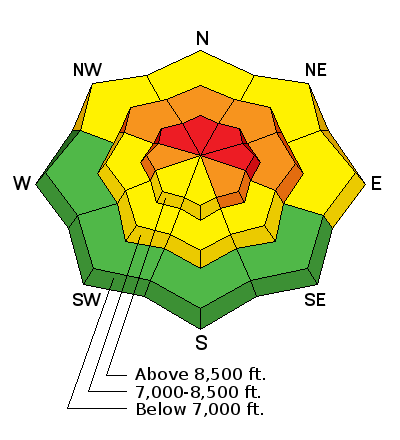
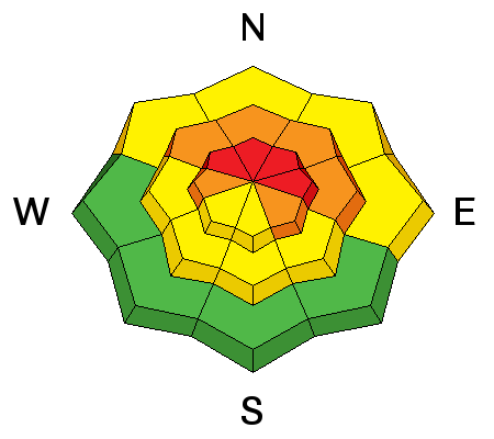
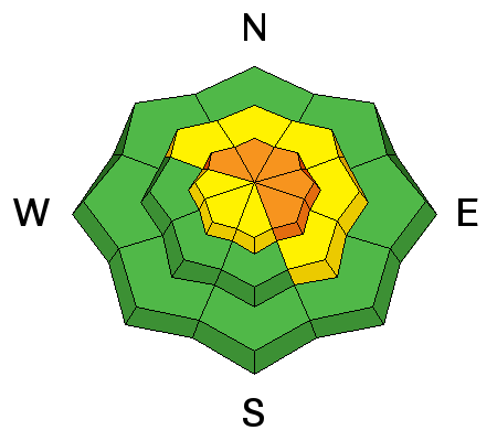
recent activity Yesterday, Ogden resort avalanche work released slides with explosives - both new snow and going to the ground, class 1s and 2s.. If you look around, there is evidence of the December 23rd Ogden avalanche cycle, that included lower elevation slopes. Natural avalanches that ran the 23rd were observed on steep, northerly facing backcountry slopes, between 8,000' and 9500', in addition to slides at the lower elevations. |
| type | aspect/elevation | characteristics |
|---|

|
|
LIKELIHOOD
 LIKELY
UNLIKELY
SIZE
 LARGE
SMALL
TREND
 INCREASING DANGER
SAME
DECREASING DANGER
|
|
description
Collapsing, cracking and avalanches. All bulls eye clues that the snow is dangerously unstable. With two storms this week, the avalanche starting zones are now more connected – and slides today will be wider and deeper. There are an alarming number of weak, faceted layers in the snowpack – variable from slope to slope, any of which could fail. These weak faceted layers will be very slow to stabilize, and avoidance is key. Avoid all travel on, below and adjacent to steep slopes facing northwesterly through easterly at the mid and upper elevations. Low elevation, shady slopes also have facets near rhe ground, so identify and avoid terrain traps, such smaller, steep gullies, creek beds and road banks. |
| type | aspect/elevation | characteristics |
|---|

|
|
LIKELIHOOD
 LIKELY
UNLIKELY
SIZE
LARGE
SMALL
TREND
 INCREASING DANGER
SAME
DECREASING DANGER
|
|
description
While more stubborn, wind drifts could still be triggered on steep slopes today – most widespread along or just off ridgelines. Once any snow gets moving, it could step down to one of the deeper weak layers, resulting in a much larger avalanche. |
 |
weather We will be under a dry and mild west to northwest flow through the end of the week. Today, skies will be partly cloudy to sunny. Temperatures will be warm – reaching into the mid to upper 30s today. Winds will mostly be light, from a westerly direction, in the 10 to 20 mph range, though winds across the higest peaks may gust into the 50 to 60 mph range at times |
| general announcements FOR MORE GENERAL INFORMATION AND FAQ, CLICK HERE Support the UAC through your daily shopping. When you shop at Smith's, or online at REI, Backcountry.com, Patagonia, NRS, Amazon, eBay a portion of your purchase will be donated to the FUAC. See our Donate Page for more details on how you can support the UAC when you shop. Benefit the Utah Avalanche Center when you buy or sell on eBay - set the Utah Avalanche Center as a favorite non-profit in your eBay account here and click on eBay gives when you buy or sell. You can choose to have your seller fees donated to the UAC, which doesn't cost you a penny This information does not apply to developed ski areas or highways where avalanche control is normally done. This advisory is from the U.S.D.A. Forest Service, which is solely responsible for its content. This advisory describes general avalanche conditions and local variations always occur. |


