25th Annual Black Diamond Fall Fundraising Party
Thursday, September 13; 6:00-10:00 PM; Black Diamond Parking Lot
25th Annual Black Diamond Fall Fundraising Party
Thursday, September 13; 6:00-10:00 PM; Black Diamond Parking Lot
| Advisory: Ogden Area Mountains | Issued by Mark Staples for Saturday - December 23, 2017 - 6:35am |
|---|

|
bottom line Today the avalanche danger is rising to CONSIDERABLE at the upper elevations on wind loaded slopes. A MODERATE danger will exist on mid elevation slopes where there is any wind loading or where the new snow is resting on old snow that became weak and faceted. This storm will help build the snowpack but it remains thin and hitting rocks or having an avalanche drag you into rocks remains a major hazard.
|
 |
special announcement Do you have all the gear you need? Check out the UAC’s online marketplace and auction for deals on resort passes, skis, packs, airbag packs, beacons, snowshoes, soft goods and much more. The auction closes at 6PM on December 28. |
 |
current conditions As of 6 a.m. 8 inches of snow (0.6 inches of water) had fallen with more coming. Temperatures above 8000 feet were around 20 degrees and winds around 9000 feet were blowing 20 mph gusting 30-40 mph from the SW. Prior to this storm there was only 1-2 feet of snow on notherly facing slopes above 8000 feet. Most southerly facing slopes were bare ground until receiving 2-5 inches of snow on Wednesday. This storm will help build the snowpack, but hitting rocks remains a serious hazard. |
 |
recent activity There has been on recent avalanche activity reported in the Ogden area mountains. |
| type | aspect/elevation | characteristics |
|---|

|
|
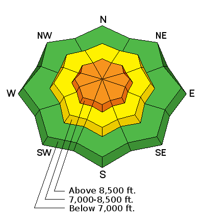
LIKELIHOOD
 LIKELY
UNLIKELY
SIZE
 LARGE
SMALL
TREND
 INCREASING DANGER
SAME
DECREASING DANGER
|
|
description
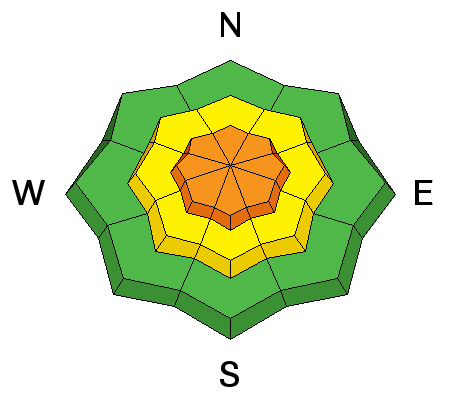
Today's snow combined with SW winds will form fresh wind slabs that should be easy to trigger today. With continued snowfall and wind through the morning and into the afternoon, these wind slabs will remain unstable and will grow in size. These wind slabs may be extra sensitive because they are resting on snow from Wednesday that became slightly faceted and weak during the cold weather. Look for these fresh wind slabs mostly on NE facing slopes as a result of SW winds, but swirling mountain winds can load or cross load slopes on all aspects. The best thing to do is simply look for evidence of fresh wind loading and avoid those areas. |
| type | aspect/elevation | characteristics |
|---|

|
|
LIKELIHOOD
 LIKELY
UNLIKELY
SIZE
LARGE
SMALL
TREND
INCREASING DANGER
SAME
DECREASING DANGER
|
|
description
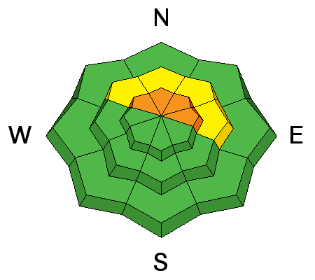
Many slopes on the northern half of the compass at mid and upper elevations that held old snow became weak and faceted. This weak snow is mostly on top of a very very hard ice crust now buried 1-2 feet deep. On slopes not affected by the wind, avalanches may break on this faceted snow if not first thing this morning, then they may happen later this afternoon. To assess this avalanche problem, test very small slopes and see how the new snow reacts under your feet. Also, dig a quick snowpit until you hit a very hard ice layer and perform a quick stability test. |
 |
weather Snowfall will continue into this afternoon until a NW flow shuts off snowfall. Depending on the timing of the NW winds, an additional 6 inches of snow should fall or maybe more. Temperatures may only warm a few degrees into the mid 20s F. Winds should continue blowing 20 mph from the SW with 30-40 mph gusts and may ease some when they shift to the NW. |
| general announcements FOR MORE GENERAL INFORMATION AND FAQ, CLICK HERE Support the UAC through your daily shopping. When you shop at Smith's, or online at REI, Backcountry.com, Patagonia, NRS, Amazon, eBay a portion of your purchase will be donated to the FUAC. See our Donate Page for more details on how you can support the UAC when you shop. Benefit the Utah Avalanche Center when you buy or sell on eBay - set the Utah Avalanche Center as a favorite non-profit in your eBay account here and click on eBay gives when you buy or sell. You can choose to have your seller fees donated to the UAC, which doesn't cost you a penny This information does not apply to developed ski areas or highways where avalanche control is normally done. This advisory is from the U.S.D.A. Forest Service, which is solely responsible for its content. This advisory describes general avalanche conditions and local variations always occur. |


