25th Annual Black Diamond Fall Fundraising Party
Thursday, September 13; 6:00-10:00 PM; Black Diamond Parking Lot
25th Annual Black Diamond Fall Fundraising Party
Thursday, September 13; 6:00-10:00 PM; Black Diamond Parking Lot
| Advisory: Ogden Area Mountains | Issued by Paige Pagnucco for Thursday - December 21, 2017 - 6:00am |
|---|

|
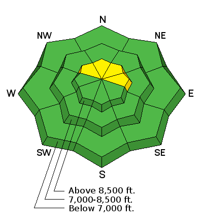
bottom line The avalanche danger is MODERATE and heightened avalanche conditions exist on high elevation slopes facing the north part of the compass that hold freshly wind drifted snow. Evaluate snow and terrain carefully. Human triggered avalanches are possible as strong winds yesterday moved and packed snow into smoothed out starting zones. Avoid steep, leeward slopes that look or feel chalky or hollow to avoid this problem today. You might also encounter loose dry sluffs in steep, sheltered terrain where new snow accumulated on top of existing weak, sugary snow. Avalanche danger is generally LOW on mid and low elevation slopes. Very thin snow cover exists across the zone so even getting caught in a small avalanche could drag you over rocks, stumps and other barely buried hazards.
|
 |
special announcement Don’t know what to buy your favorite skier for Christmas? Discount lift tickets for Alta, Snowbird, Brighton, Solitude, Deer Valley, Snowbasin,and Beaver Mountain are now available, donated by the resorts to benefit the Utah Avalanche Center. Details and order information here. These make a great holiday gift and all proceeds go towards paying for avalanche forecasting and education! |
 |
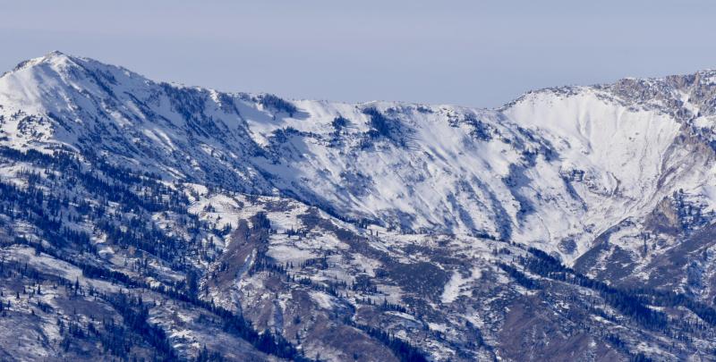
current conditions Yesterday's storm appears to have been "the storm that wasn't." Snowfall totals range from 2-5" of cold, light density snow. While that may improve riding conditions ever so slightly, it is still a far cry from a desired, "classic" Utah dump. Currently, chilly mountain temperatures are in the high single digits F and northerly winds are blowing 10-15 mph with higher gusts near the ridgetops. Backcountry travel has been limited with total snow on the ground on shady, upper elevation slopes only around 12-18" and much of it weak sugary facets over a variey of crusts. Sunny slopes are a mix of crusty snow and bare ground, and there’s thin snow at the mid and lower elevations. Much of the snow that fell yesterday and overnight day landed on bare ground. View the latest Ogden observations here.
Cutler Ridge and Ben Lomond east face on 12/19/17. Slopes like these that are covered with weak old snow are most suspect for avalanche potential. |
 |
recent activity None. |
| type | aspect/elevation | characteristics |
|---|

|
|
LIKELIHOOD
 LIKELY
UNLIKELY
SIZE
 LARGE
SMALL
TREND
 INCREASING DANGER
SAME
DECREASING DANGER
|
|
description
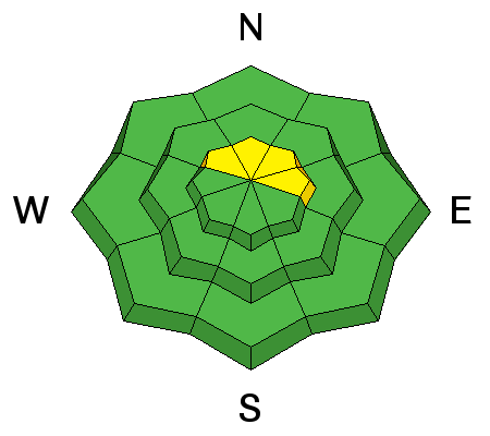
Despite the smaller than expected snowfall amounts, winds were strong enough yesterday to create wind slabs in high elevation terrain. These are of greatest concern on slopes that have existing old snow cover, particularly northwest through east facing. These slopes hold a smooth, shallow coating of weak faceted surface snow on top of a hard crust. The crust has essentially raised the ground level and, because it is smooth and widely distributed, provides a nice bed surface for an avalanche to run on. Stay off of and out from underneath steep, wind drifted slopes to avoid this problem. Even a small ride in steep terrain can cause serious injury due to rocks, stumps and generally thin snowcover. |
| type | aspect/elevation | characteristics |
|---|

|
|
LIKELIHOOD
LIKELY
UNLIKELY
SIZE
LARGE
SMALL
TREND
INCREASING DANGER
SAME
DECREASING DANGER
|
|
description
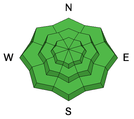
The current snowpack on shady slopes consists of crusts and sugary, faceted weak snow. You may encounter loose, dry snow sluffs in sheltered, steep terrain. Though this type of avalanche is usually fairly predictable, it can knock you off your feet and, with generally thin snow cover, send you over rocks and other exposed hazards. Stick to lower angle terrain where there's grass or a smooth surface underneath to avoid this problem as well as enjoy better riding conditions. |
 |
weather Today will be chilly in the mountains with only a small chance for lingering snow showers this morning. Skies will be mostly sunny by the afternoon. Temperatures will be in the teens but will feel much colder thanks to northerly winds blowing 10-15 mph. The next good chance for snow looks to occur Friday night into Saturday as a stronger, more organized system crosses in the region. Hopefully. |
| general announcements To view our general announcements, click here.
|