25th Annual Black Diamond Fall Fundraising Party
Thursday, September 13; 6:00-10:00 PM; Black Diamond Parking Lot
25th Annual Black Diamond Fall Fundraising Party
Thursday, September 13; 6:00-10:00 PM; Black Diamond Parking Lot
| Advisory: Ogden Area Mountains | Issued by Paige Pagnucco for Wednesday - December 20, 2017 - 6:01am |
|---|

|
bottom line As the storm moves in today, the avalanche danger will rise to MODERATE and heightened avalanche conditions will exist. Human triggered avalanches will be possible as strong southwest winds and moderate snowfall will form wind slabs in high elevation terrain facing northwest through east today. Evaluate snow and terrain carefully - avoid steep slopes with freshly wind drifted snow. Loose dry snow avalanches and storm slabs will also be possible in sheltered high elevation terrain as new snow lands on the weak existing surface snow. If we experience stronger winds or more than expected snowfall, there is a chance the danger will rise to Considerable with the potential for natural avalanche activity. Very thin snow cover exists across the zone so even getting caught in a small avalanche could drag you over rocks, stumps and other barely buried hazards.
|
 |
special announcement Don’t know what to buy your favorite skier for Christmas? Discount lift tickets for Alta, Snowbird, Brighton, Solitude, Deer Valley, Snowbasin,and Beaver Mountain are now available, donated by the resorts to benefit the Utah Avalanche Center. Details and order information here. These make a great holiday gift and all proceeds go towards paying for avalanche forecasting and education! |
 |
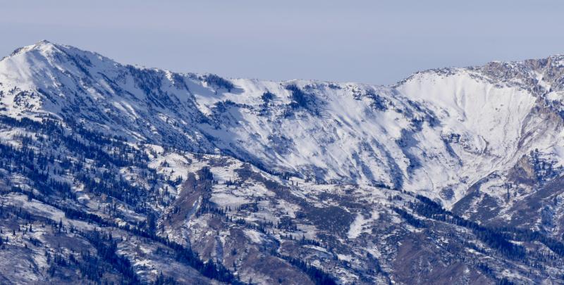
current conditions This morning temperatures are mild with mid 30's F around 8000 ft. Winds are blowing 20-30 mph from the southwest with ridgetop gusts 40+ mph. It's the classic "warm before the storm" set up this morning as we anticipate the arrival of today's cold winter storm. Temperatures are expected to fall steadily troughout the day as the cold front passes through. Backcountry travel has been limited prior to today with total snow on the ground on shady, upper elevation slopes only around 12-18" and much of it weak sugary facets over a variey of crusts. Sunny slopes are a mix of crusty snow and bare ground, and there’s only patchy snow at the mid and lower elevations. Much of the snow that falls today will land on bare ground. View the latest Ogden observations here.
Cutler Ridge and Ben Lomond east face on 12/19/17. Slopes like these that are covered with weak old snow will be most suspect for avalanche potential today. |
 |
recent activity None. |
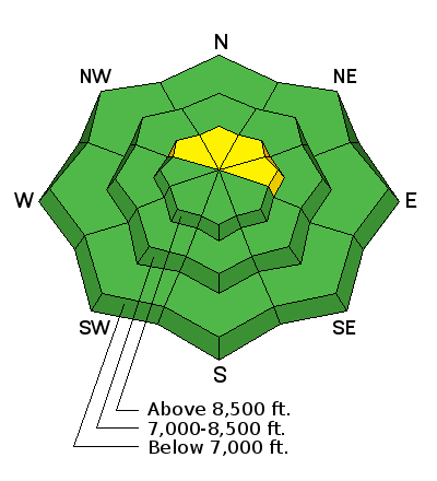
| type | aspect/elevation | characteristics |
|---|

|

|
LIKELIHOOD
 LIKELY
UNLIKELY
SIZE
 LARGE
SMALL
TREND
 INCREASING DANGER
SAME
DECREASING DANGER
|
|
description
Strong southwest winds blowing 20-30 mph with gusts in to the 40's will combine with moderate snowfall to create wind slabs today. These will be of greatest concern on slopes that have existing snow cover, particularly northwest through east facing, high elevation terrain. These slopes have a smooth, shallow coating of weak faceted surface snow on top of a hard crust. The crust has essentially raised the ground level and, because it is smooth and widely distributed, will likely provide a nice bed surface for an avalanche to run on. Stay off of wind drifted steep slopes to avoid this problem. Even a small ride in steep terrain can cause serious injury due to rocks, stumps and generally thin snowcover. |
| type | aspect/elevation | characteristics |
|---|

|
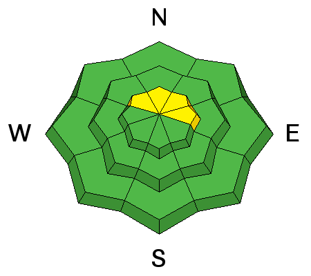
|
LIKELIHOOD
LIKELY
UNLIKELY
SIZE
 LARGE
SMALL
TREND
INCREASING DANGER
SAME
DECREASING DANGER
|
|
description
The current snowpack on shady slopes consists of crusts and sugary, faceted weak snow. If we get a decent shot of snow today, you'll likely encounter loose dry snow sluffs in sheltered, steep terrain. Though this type of avalanche is usually fairly predictable, it can knock you off your feet and, with generally thin snow cover, send you over rocks and other exposed hazards. Stick to lower angle terrain where there's grass or a smooth surface underneath to avoid this problem as well as enjoy better riding conditions. |
| type | aspect/elevation | characteristics |
|---|

|

|
LIKELIHOOD
 LIKELY
UNLIKELY
SIZE
LARGE
SMALL
TREND
INCREASING DANGER
SAME
DECREASING DANGER
|
|
description
With forecasted snowfall totals around 6-12" for the Ogden area mountains, we might see just plain old storm slabs developing on high elevation and maybe a few mid elevation sheltered, steep slopes. The new snow is landing on old, weak snow so notice any red flags like collapsing as you travel today and adjust your terrain choices appropriately. Lower angle slopes are safer and will provide better riding conditions on our still early season-like, shallow snowpack. |
 |
weather The National Weather Service has issued a Winter Weather Advisory effective from 10 am today through 10 am tomorrow. A cold storm system will move into the area today bringing strong southwesterly winds, with ridgetop gusts over 40 mph, and snow. Forecasted storm totals hover around 6-12". A cold front passes through this afternoon and will shift the flow and winds to the northwest. Snowfall rates are expected to reach peak this afternoon and taper off steadily overnight. The storm should clear out by Thursday midday with a few lingering showers. In it's wake the Ogden mountains will be left with blustery north winds and very cold temperatures. Another system is in line for Friday/Saturday bringing even colder temperatures and not much chance for accumulation. There is loose talk of another storm mid next week but the models show low certainty and general disagreement. |
| general announcements To view our general announcements, click here.
|