25th Annual Black Diamond Fall Fundraising Party
Thursday, September 13; 6:00-10:00 PM; Black Diamond Parking Lot
25th Annual Black Diamond Fall Fundraising Party
Thursday, September 13; 6:00-10:00 PM; Black Diamond Parking Lot
| Advisory: Ogden Area Mountains | Issued by Trent Meisenheimer for Wednesday - December 13, 2017 - 6:25am |
|---|


|
bottom line The avalanche danger is LOW. Generally safe avalanche conditions. Watch for unstable snow on isolated terrain features, mostly confined to upper elevation north and east facing slopes that recieved wind drifted snow from the wind event last Thursday December 7th. Utah Department of Trasportation has two backcountry closures in effect this morning. One in Big Cottonwood Canyon and the other is in Provo Canyon - click here for more details.
|
 |
special announcement With no change in conditions expected or any storms on the horizon, we will be issuing intermittent advisories. Be sure to catch "A Meditation on Rescue" Presendted by Drew Hardestly and Terry O'Conner MD this evening at The Black Diamond Store. Details here Get important updates from the UAC via text message directly to your phone. Its very simple - text 40404 and send this message "Follow uacwasatch". Looking for a great stocking stuffer for Christmas? Discount lift tickets for Alta, Snowbird, Brighton, Solitude, Deer Valley, Snowbasin,and Beaver Mountain are now available, donated by the resorts to benefit the Utah Avalanche Center. Details and order information here. These make a great holiday gift and all proceeds go towards paying for avalanche forecasting and education! Please abide by the uphill travel policies of the ski resorts. Info here. |
 |
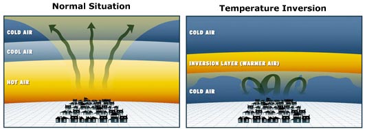
current conditions Temperatures this morning tell the tale; Outside the forecast office we have a current temperature of 24° degrees F. Move up in elevation to Farmington Peak 8,000' feet and the current temperature is 41°F. If the fact that we can't see the sun in the valley doesn't give away that we are under a strong inversion then hopefully the temperatures will convince you. Inversions are simple - high pressure (warmer & less dense air) up in the atmosphere forces the colder & more dense air to sink and become stagnant in the valleys. Normally, warmer air is under the colder more dense air allowing the warmer air to rise and turn over which creates mixing in the atmosphere.
Many of the lower elevation trailhead temperatures are in the mid to low 20's - while the mid to upper elevation peaks are in the upper 30's. West-north-west winds are averaging 10-15 mph with the occasional gust into the 20's across the high ridge lines. Riding and turning conditions vary greatly over the different aspects and elevations. There is very little snow below 7500' in elevation, while at 9,400' feet on the northerly aspects our snowpack varies from 12 to 36 inches of snow (1-3 ft). The best turning and riding conditions will be found on upper elevation north facing low angle terrain. Many of the sunlit aspects will be crusted in the morning and should soften with the daytime heating. View the latest observations here. |
 |
recent activity There have been no recently reported avalanches. |
| type | aspect/elevation | characteristics |
|---|

|
|
LIKELIHOOD
 LIKELY
UNLIKELY
SIZE
 LARGE
SMALL
TREND
 INCREASING DANGER
SAME
DECREASING DANGER
|
|
description
LOW danger does not mean NO danger. Small avalanches can still be triggered in isolated places or radical terrain. The most likely place to trigger any of these slides would be on a steep, upper elevation northwest through northeasterly facing slope. Watch for wind drifts following last week's northeast winds. Also, watch for loose snow sluffs on steep sustained slopes. Now is a great time for a shake down tour -make sure all your gear is working properly and your beacon, shovel, and probe are in good working order. It's also a great time to read your favorite avalanche book, take a class, or watch this simple video below. Once we get a decent storm here in Utah we can expect dangerous avalanche conditions. Know Before You Go from Trent Meisenheimer on Vimeo. |
 |
weather More sunshine and some thin clouds are on tap for the mountains of northern Utah today. Temperatures will start in the mid to low 30's °F and climb into the low 40's °F this afternoon. The northerly winds will average 5 to 15 mph, with the highest peaks averaging 20 to 30 mph. A weak weather system will brush by the area to our east late this afternoon through tonight, bringing a chance of light snow. High pressure will return for Thursday and Friday. The next chance for snow will be Friday night into Saturday morning. The good news, this small storm might have what it takes to mix the air in the valleys and bring a few inches to the mountains. Fingers crossed! |
general announcements
|