25th Annual Black Diamond Fall Fundraising Party
Thursday, September 13; 6:00-10:00 PM; Black Diamond Parking Lot
25th Annual Black Diamond Fall Fundraising Party
Thursday, September 13; 6:00-10:00 PM; Black Diamond Parking Lot
| Advisory: Ogden Area Mountains | Issued by Mark Staples for Wednesday - December 6, 2017 - 7:19am |
|---|

|
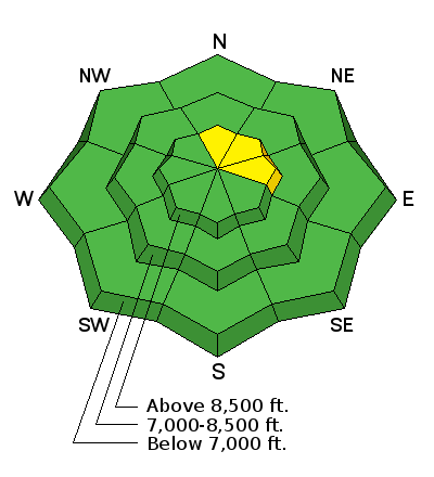
bottom line Today with a isolated wind slabs and isolated pockets of faceted snow on the highest elevations (above 9000 ft), the avalanche danger is MODERATE on northerly facing slopes at upper elevations. On most other slopes there is hardly enough snow to ride and the avalanche danger is LOW. The dilemma is that slopes with the best coverage (a relative term), are ones most likely to harbor some faceted snow. Two options are to simply choose slopes less than 30 degrees in steepness to avoid avalanches, or dig into the snow and make sure no faceted layers exist. With limited terrain available for riding (low tide as some call it), take the time to practice with your rescue gear if you get out.
|
 |
special announcement Get important updates from the UAC via text message directly to your phone. Its very simple - dial 40404 and send this message "Follow uacwasatch". Looking for a great stocking stuffer for Christmas? Discount lift tickets for Alta, Snowbird, Brighton, Solitude, Deer Valley, Snowbasin,and Beaver Mountain are now available, donated by the resorts to benefit the Utah Avalanche Center. Details and order information here. These make a great holiday gift and all proceeds go towards paying for avalanche forecasting and education! There are still spots left for the FREE Avalanche Awareness for Women evening talk TONIGHT, December 5th, presented by the SLC REI, SheJumps and the Utah Avalanche Center. Sign up for free with REI HERE. Please abide by the uphill travel policies of the ski resorts. Info here. |
 |
current conditions This morning temperatures are mostly around 15 degrees F. A few low spots have single digit temperatures. Winds at ridgetops increased since yesterday and are blowing from the north 15 mph gusting to 20 mph. The storm from Sunday/Monday delivered 8-14", with up to 6" at the trailheads. While this was a huge improvement, conditions still remain very thin. |
 |
recent activity Two days ago, one experienced backcountry skier found a few fresh wind slabs he intentionally triggered 4-8" deep and 40' wide well below the Ogden skyline. One slab broke at his skis; another one was triggered from a distance. |
| type | aspect/elevation | characteristics |
|---|

|
|
LIKELIHOOD
 LIKELY
UNLIKELY
SIZE
 LARGE
SMALL
TREND
 INCREASING DANGER
SAME
DECREASING DANGER
|
|
description
The greatest hazard is the thin snow cover and hitting rocks whether from riding, falling or from avalanches. Some weak, faceted snow exist in the snowpack in the Ogden area, but most of the Sept/Oct/Nov snow either melted away, or warmed enough to melt and refreeze. Unfortunately, this situation may change in the coming week and I expect much of the snow currently on the ground to weaken and facet on most aspects except due south. For now, the main thing to watch for are any fresh wind slabs. Winds have mostly been blowing in the teens and fresh winds slabs should be very isolated. The few areas that may harbor faceted snow may remain unstable The snow is mostly stable but for pockets of lingering wind slab and fast moving sluffs in the low density snow. While weak snow exists in the mid-pack, not enough snow and wind arrived to activate these persistent weaknesses. |
 |
weather Today will have more clear and cold weather. Winds will continue and even increase some from the North at 15-25 mph with some higher gusts. Temperatures will rise into the upper 20's F. For the long term weather forecast - sadly, no snow is expected in the next 7-10 days. |
general announcements
|


