25th Annual Black Diamond Fall Fundraising Party
Thursday, September 13; 6:00-10:00 PM; Black Diamond Parking Lot
25th Annual Black Diamond Fall Fundraising Party
Thursday, September 13; 6:00-10:00 PM; Black Diamond Parking Lot
| Advisory: Ogden Area Mountains | Issued by Paige Pagnucco for Saturday - April 15, 2017 - 6:57am |
|---|


|
bottom line After a solid overnight refreeze, the avalanche danger is LOW. Continue to use normal caution.
|
 |
special announcement Great news… so far there haven’t been any avalanche fatalities in Utah this winter! It has been 26 years since we’ve had a fatality-free winter. Let’s keep it that way and stay safe this spring. Our goal is for everyone to enjoy the Greatest Snow on Earth and come home safe every day. The final regular advisory will be this Sunday, April 16. For the rest of the month we'll issue updates any time there is measurable snowfall; however, we will discontinue issuing avalanche danger ratings after Sunday. Want to know about more about spring conditions? Want to be your own forecaster? Check out this short video ... https://youtu.be/ukS6YxZTOt0 |
 |
current conditions Under clear skies temperatures this morning are chilly - 24 F at Ben Lomond, 16 F at Mt. Ogden, and 17 F at Monte Cristo. Winds are blowing 10-15 mph out of the west. With overnight temps in the teens, the snow will be very firm and slow to soften this morning. This is my last forecast of the season and I want to say a HUGE thank you to a few folks:
|
 |
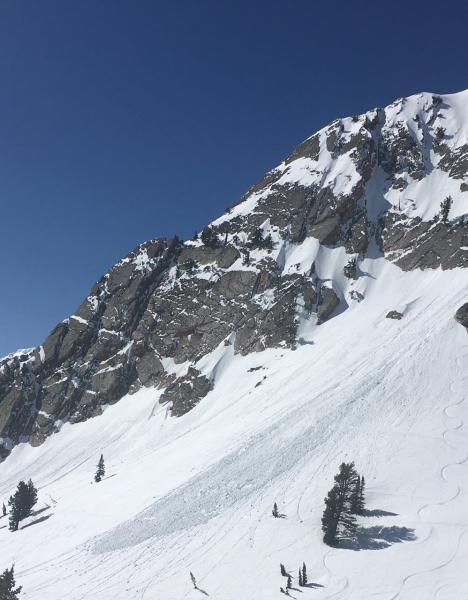
recent activity A few small, wet loose avalanches were reported Thursday. On Wednesday, a human triggered wet loose avalanche in Mt.Ogden Chute was large enough to burry a person.
|
| type | aspect/elevation | characteristics |
|---|

|
|
LIKELIHOOD
 LIKELY
UNLIKELY
SIZE
 LARGE
SMALL
TREND
 INCREASING DANGER
SAME
DECREASING DANGER
|
|
description
Cold temperatures and clear skies refroze the snowpack overnight. With forecast cool temperatures and northerly winds, any loose wet snow activity should be minimal today. Keep a few things in mind though:
|
 |
weather Today will be a stunner in the mountains - sunny skies, temps in the low 30's F, and light northwesterly winds blowing 5-10 mph. Sunday will bring warmer temps ahead of unsettled weather for the coming week. |
| general announcements Remember your information can save lives. If you see anything we should know about, please help us out by submitting snow and avalanche conditions. You can also call us at 801-524-5304, email by clicking HERE, or include #utavy in your tweet or Instagram. To get help in an emergency (to request a rescue) in the Wasatch, call 911. Be prepared to give your GPS coordinates or the run name. Dispatchers have a copy of the Wasatch Backcountry Ski map. Backcountry Emergencies. It outlines your step-by-step method in the event of a winter backcountry incident. If you trigger an avalanche in the backcountry, but no one is hurt and you do not need assistance, please notify the nearest ski area dispatch to avoid a needless response by rescue teams. Thanks.
EMAIL ADVISORY If you would like to get the daily advisory by email you will need to subscribe here. DAWN PATROL Hotline updated daily by 5-530am - 888-999-4019 option 8. TWITTER Updates for your mobile phone - DETAILS UDOT canyon closures: LINK TO UDOT, or on Twitter, follow @UDOTavy, @CanyonAlerts or @AltaCentral Utah Avalanche Center mobile app - Get your advisory on your iPhone along with great navigation and rescue tools. Powderbird Helicopter Skiing - Blog/itinerary for the day Lost or Found something in the backcountry? - http://nolofo.com/ To those skinning uphill at resorts: it is critical to know the resort policy on uphill travel. You can see the uphill travel policy for each resort here. Benefit the Utah Avalanche Center when you shop from Backcountry.com or REI: Click this link for Backcountry.com or this link to REI, shop, and they will donate a percent of your purchase price to the UAC. Both offer free shipping (with some conditions) so this costs you nothing! Benefit the Utah Avalanche Center when you buy or sell on ebay - set the Utah Avalanche Center as a favorite non-profit in your ebay account here and click on ebay gives when you buy or sell. You can choose to have your seller fees donated to the UAC, which doesn't cost you a penny. This information does not apply to developed ski areas or highways where avalanche control is normally done. This advisory is from the U.S.D.A. Forest Service, which is solely responsible for its content. This advisory describes general avalanche conditions and local variations always occur |