25th Annual Black Diamond Fall Fundraising Party
Thursday, September 13; 6:00-10:00 PM; Black Diamond Parking Lot
25th Annual Black Diamond Fall Fundraising Party
Thursday, September 13; 6:00-10:00 PM; Black Diamond Parking Lot
| Advisory: Ogden Area Mountains | Issued by Paige Pagnucco for Friday - April 14, 2017 - 6:20am |
|---|

|
bottom line The avalanche danger is LOW. Generally safe avalanche conditions exist but watch for unstable snow in isolated areas. Triggered loose wet avalanches might be possible if temperatures rise more than expected, especially on slopes that receive direct sunlight as the cloud cover breaks today. (This forecast was produced by UAC intern Kory Davis with the help of Paige Pagnucco.)
|
 |
special announcement Great news… so far there haven’t been any avalanche fatalities in Utah this winter! It has been 26 years since we’ve had a fatality-free winter. Let’s keep it that way and stay safe this spring. Our goal is for everyone to enjoy the Greatest Snow on Earth and come home safe every day. The final regular advisory will be this Sunday, April 16. For the rest of the month we'll issue updates any time there is measurable snowfall; however, we will discontinue issuing avalanche danger ratings after Sunday. Snowbasin Lift tickets available for $50 go HERE to purchase or call 800-233-7189 |
 |
current conditions After yesterday's warm and windy conditions, the weather cooled off overnight creating a substantial freeze at mid and upper elevations. Upper elevation temperatures are; 26 F at Boardwalk (Snowbasin), 30 F at Ben Lomond, and 27 F at Monte Cristo. The winds came to a screeching halt overnight but not before we recorded a max gust of 82mph on Mt. Ogden. Southwesterly winds are currently 5-15 mph in the Ogden mountains. Temperatures today should stay in the 30’s. Finding cold snow is unlikely but with a little warming we could see some softer conditions on warmer aspects. |
 |
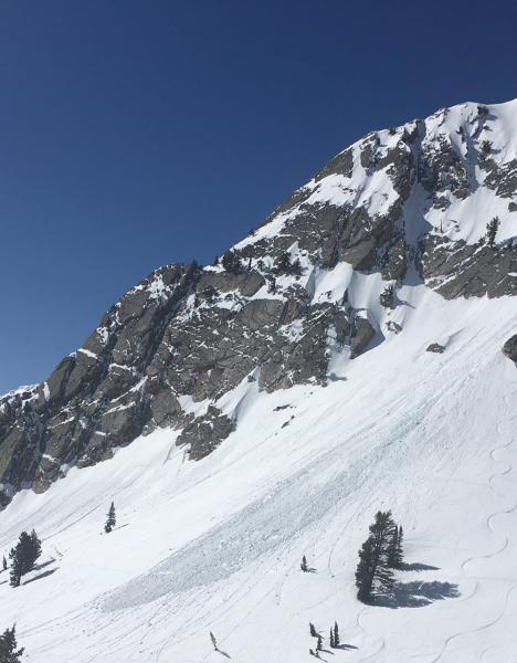
recent activity A few small, wet loose avalanches were reported yesterday. On Wednesday, a human triggered wet loose avalanche in Mt. Ogden Chute was large enough to burry a person.
pc: P. Pagnucco |
| type | aspect/elevation | characteristics |
|---|

|

|
LIKELIHOOD
 LIKELY
UNLIKELY
SIZE
 LARGE
SMALL
TREND
 INCREASING DANGER
SAME
DECREASING DANGER
|
|
description
The overall danger is low, but remember to always be prepared in case of an emergency. Cornice fall - Give cornices a wide berth and stay off of and out from under them. Even with cooler temperatures, cornices can fail at any moment. Slide for life - Very hard snow surfaces exist and mountain travelers may want to carry an ice axe, or whippet for self arrest. Wet loose avalanches - Look for signs of instability especially if temperatures rise higher than forecasted, at lower elevations as the temperature rises, and in areas that attract direct sun. Weather can change very quickly this time of year. Look for rollerballs and pinwheels as signs of changing conditions. Safe travel protocol - As always when we travel into the backcountry remember to carry the proper tools; beacon, shovel, probe. Do not get lulled into making poor decisions. |
 |
weather As last night's windy, dry cold front moves out, winds today will reach 10-20 mph with gust in the 20’s on exposed ridges. Temperatures will rise to the low 30’s F at upper elevations and low 40’s F at lower elevations. Rapid warming with lots of sunshine Saturday into Sunday will bring mountain temperatures into the 40’s and 50’s by Sunday. |
| general announcements Remember your information can save lives. If you see anything we should know about, please help us out by submitting snow and avalanche conditions. You can also call us at 801-524-5304, email by clicking HERE, or include #utavy in your tweet or Instagram. To get help in an emergency (to request a rescue) in the Wasatch, call 911. Be prepared to give your GPS coordinates or the run name. Dispatchers have a copy of the Wasatch Backcountry Ski map. Backcountry Emergencies. It outlines your step-by-step method in the event of a winter backcountry incident. If you trigger an avalanche in the backcountry, but no one is hurt and you do not need assistance, please notify the nearest ski area dispatch to avoid a needless response by rescue teams. Thanks.
EMAIL ADVISORY If you would like to get the daily advisory by email you will need to subscribe here. DAWN PATROL Hotline updated daily by 5-530am - 888-999-4019 option 8. TWITTER Updates for your mobile phone - DETAILS UDOT canyon closures: LINK TO UDOT, or on Twitter, follow @UDOTavy, @CanyonAlerts or @AltaCentral Utah Avalanche Center mobile app - Get your advisory on your iPhone along with great navigation and rescue tools. Powderbird Helicopter Skiing - Blog/itinerary for the day Lost or Found something in the backcountry? - http://nolofo.com/ To those skinning uphill at resorts: it is critical to know the resort policy on uphill travel. You can see the uphill travel policy for each resort here. Benefit the Utah Avalanche Center when you shop from Backcountry.com or REI: Click this link for Backcountry.com or this link to REI, shop, and they will donate a percent of your purchase price to the UAC. Both offer free shipping (with some conditions) so this costs you nothing! Benefit the Utah Avalanche Center when you buy or sell on ebay - set the Utah Avalanche Center as a favorite non-profit in your ebay account here and click on ebay gives when you buy or sell. You can choose to have your seller fees donated to the UAC, which doesn't cost you a penny. This information does not apply to developed ski areas or highways where avalanche control is normally done. This advisory is from the U.S.D.A. Forest Service, which is solely responsible for its content. This advisory describes general avalanche conditions and local variations always occur |