25th Annual Black Diamond Fall Fundraising Party
Thursday, September 13; 6:00-10:00 PM; Black Diamond Parking Lot
25th Annual Black Diamond Fall Fundraising Party
Thursday, September 13; 6:00-10:00 PM; Black Diamond Parking Lot
| Advisory: Ogden Area Mountains | Issued by Paige Pagnucco for Friday - March 31, 2017 - 6:54am |
|---|

|
bottom line At upper elevations, the avalanche danger is MODERATE and human-triggered wind slab avalanches are possible. At mid and low elevations, triggered loose wet snow avalanches might be possible.
|
 |
current conditions The mountains received about 3-6" of snow since yesterday and 8000' temperatures are near freezing this morning. Winds are blowing 10-20 mph, with locally higher gusts, from the east northeast, a unique wind direction for the zone. The mountains saw enough snow to cover the corn but not enough to call it a "powder" day. Snowbasin picked up 3", Powder Mt. 6", and Ben Lomond is showing .40" of snow water equivalent in the past 24 hrs. Dense. Slow. Moist. Variable. Just some of the words used to describe recent riding conditions. The snow today will range from crusty up high to mushy at mid and low elevations. Not exactly inspiring. |
 |
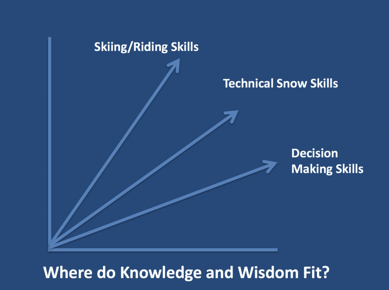
recent activity No reports from the backcountry for over a week but resorts observed shallow slab and small cornice activity yesterday. Cooler temperatures kept significant wet activity at bay. Wise words from Drew in case you missed it yesterday ..."And another thing. It occurs to me that only tragedy, poor decision-making and the like are the only things that make the headlines. You never see a situation where the hero of the story describes going into the mountains with a well-researched plan and a good and competent partner...observes conditions not to her liking...and - get this - makes a calculated decision to TURN AROUND. A good nod of respect...and you can read more here. Generally speaking on our backcountry learning curves, we develop our skiing and riding skills first, followed by our understanding of snow and avalanches...but it's our decision-making skills that often lag far behind."
|
| type | aspect/elevation | characteristics |
|---|

|
|
LIKELIHOOD
 LIKELY
UNLIKELY
SIZE
 LARGE
SMALL
TREND
 INCREASING DANGER
SAME
DECREASING DANGER
|
|
description
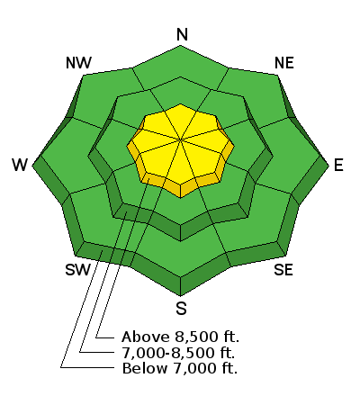
With new, albeit dense, snow available for transport you'll want to watch for areas of freshly wind drifted snow on upper elevation steep slopes. Though warm temperatures helped the new snow bond to the existing snow surface, there may be isolated pockets where you could trigger shallow wind slabs, especially in areas where the underlying surface was previously frozen or icy. With today's forecast easterly winds, avoid fresh cornices and wind drifts especially on the western half of the compass as well as cross loaded terrain features. |
| type | aspect/elevation | characteristics |
|---|

|
|
LIKELIHOOD
LIKELY
UNLIKELY
SIZE
LARGE
SMALL
TREND
 INCREASING DANGER
SAME
DECREASING DANGER
|
|
description
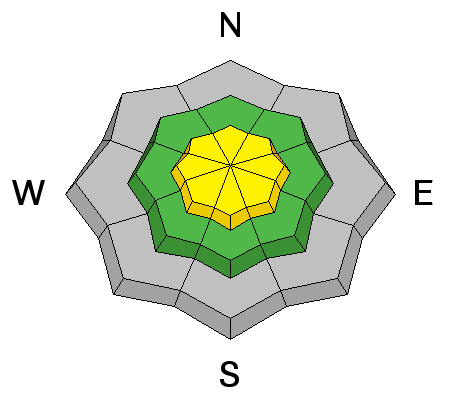
With a poor overnight refreeze, triggered loose wet avalanches might occur on steep slopes, particularly at mid and low elevations. Watch for signs of instability like roller balls. If you start sinking in more than a few inches, it's time to move to lower angle terrain. |
| type | aspect/elevation | characteristics |
|---|

|
|
LIKELIHOOD
 LIKELY
UNLIKELY
SIZE
 LARGE
SMALL
TREND
 INCREASING DANGER
SAME
DECREASING DANGER
|
|
description
Remember that risk is inherent in mountain travel. Considerations for today:
|
 |
weather Today - Snow likely. Cloudy, with a high near 38. East northeast wind 11 to 18 mph. Chance of precipitation is 70%. Total daytime snow accumulation of less than one inch possible. Tonight - Mostly cloudy, with a low around 33. East northeast wind 17 to 20 mph. Saturday - Mostly sunny, with a high near 42. East wind 6 to 16 mph. The next chance for precipitation is Sunday into Monday though the system appears to be losing steam, possibly only bringing cooler temperatures. |
| general announcements Remember your information can save lives. If you see anything we should know about, please help us out by submitting snow and avalanche conditions. You can also call us at 801-524-5304, email by clicking HERE, or include #utavy in your tweet or Instagram. To get help in an emergency (to request a rescue) in the Wasatch, call 911. Be prepared to give your GPS coordinates or the run name. Dispatchers have a copy of the Wasatch Backcountry Ski map. Backcountry Emergencies. It outlines your step-by-step method in the event of a winter backcountry incident. If you trigger an avalanche in the backcountry, but no one is hurt and you do not need assistance, please notify the nearest ski area dispatch to avoid a needless response by rescue teams. Thanks.
EMAIL ADVISORY If you would like to get the daily advisory by email you will need to subscribe here. DAWN PATROL Hotline updated daily by 5-530am - 888-999-4019 option 8. TWITTER Updates for your mobile phone - DETAILS UDOT canyon closures: LINK TO UDOT, or on Twitter, follow @UDOTavy, @CanyonAlerts or @AltaCentral Utah Avalanche Center mobile app - Get your advisory on your iPhone along with great navigation and rescue tools. Powderbird Helicopter Skiing - Blog/itinerary for the day Lost or Found something in the backcountry? - http://nolofo.com/ To those skinning uphill at resorts: it is critical to know the resort policy on uphill travel. You can see the uphill travel policy for each resort here. Benefit the Utah Avalanche Center when you shop from Backcountry.com or REI: Click this link for Backcountry.com or this link to REI, shop, and they will donate a percent of your purchase price to the UAC. Both offer free shipping (with some conditions) so this costs you nothing! Benefit the Utah Avalanche Center when you buy or sell on ebay - set the Utah Avalanche Center as a favorite non-profit in your ebay account here and click on ebay gives when you buy or sell. You can choose to have your seller fees donated to the UAC, which doesn't cost you a penny. This information does not apply to developed ski areas or highways where avalanche control is normally done. This advisory is from the U.S.D.A. Forest Service, which is solely responsible for its content. This advisory describes general avalanche conditions and local variations always occur |