25th Annual Black Diamond Fall Fundraising Party
Thursday, September 13; 6:00-10:00 PM; Black Diamond Parking Lot
25th Annual Black Diamond Fall Fundraising Party
Thursday, September 13; 6:00-10:00 PM; Black Diamond Parking Lot
| Advisory: Ogden Area Mountains | Issued by Trent Meisenheimer for Tuesday - March 28, 2017 - 7:20am |
|---|

|
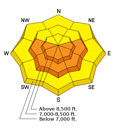
bottom line The avalanche danger will quickly rise to CONSIDERABLE this morning for wet loose avalanches on all steep mid and upper elevation slopes that face the sunny half of the compass. You'll find a MODERATE danger for storm slab avalanches on mid to upper elevation slopes that face the north half of the compass. If you don't want to deal with avalanches today: it's simple. Stick to upper elevation north facing terrain that's less than 33 degrees in slope steepness. Avoid being on or underneath anything steep above or adjacent to you - do this and great power skiing awaits. Continue to avoid traveling below the large cornices and opening glide cracks.
|
 |
special announcement Thursday, March 30, is Love Utah Give Utah day. Between now and then, when you donate to the charities that make living in Utah better using this link, you will automatically be entered to win a 3 year lease on a 2017 Subaru Impreza from Mark Miller Subaru. Plus getting karma points and benefiting your community. The Utah Avalanche Center counts on partners like you for support. https://loveutgiveut.razoo.com/story/Utahavalanchecenter Support Wasatch Backcountry Rescue at the 3rd Annual Bow Wow fundraiser on Thursday, March 30th at 6pm at OP Rockwells in Park City. Details HERE. |
 |
current conditions A nice re-fresh for the mountains of northern Utah, delivering 2-8" of snow (0.2"-0.7" h20) throughout the Ogden area. The snow tapered off last night around 11:00 pm and the storm is now exiting to our east this morning. Mostly clear skies this morning in the valleys. However, In the mountains you'll find some clouds grasping onto peaks and hanging around for the morning hours. Current temperatures are cool with upper elevation thermometers reading 20°F. Northwest winds overnight picked up and are currently blowing 15-20 mph with gusts into the 30's. Riding conditions will be greatly improved this morning - you'll find the best turning and riding conditions at upper elevations on the north half of the compass. |
 |
recent activity Yesterday afternoon, many backcountry riders as well as control teams reported a natural avalanche cycle within the new snow . This was caused by an intense period of high snow fall in a short period of time. All of the avalanches failed within the new snow. |
| type | aspect/elevation | characteristics |
|---|

|
|
LIKELIHOOD
 LIKELY
UNLIKELY
SIZE
 LARGE
SMALL
TREND
 INCREASING DANGER
SAME
DECREASING DANGER
|
|
description
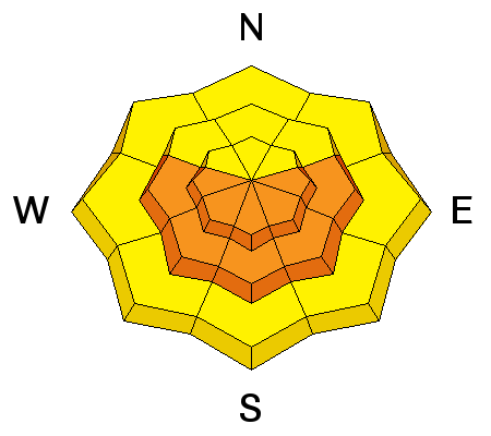
Anytime we get new cold snow in the spring and the sun comes out - you get wet loose avalanches on the steep sunlit slopes and this morning will be no exception. As the sun starts heating the snow pay close attention to the surface, if it becomes damp and heavy it's time to leave. With 6-13" inches of new snow I would expect that wet loose avalanches will be large enough to catch, carry and bury a person today. Avoid traveling in steep sunny terrain where the snow surface becomes wet and unstable. This doesn't mean you can't ride - all you have to do is swing around to the north facing terrain, where the snow will be much cooler in temperature (see storm snow). |
| type | aspect/elevation | characteristics |
|---|

|
|
LIKELIHOOD
 LIKELY
UNLIKELY
SIZE
LARGE
SMALL
TREND
 INCREASING DANGER
SAME
DECREASING DANGER
|
|
description
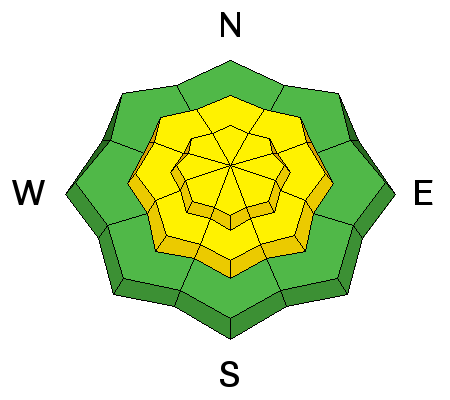
In the spring our storms can vary greatly in temperatures, leading to density changes within the new storm snow. Often times these density changes will make the new snow unstable for a period of time. Yesterday, on my field day I found these storm slabs very sensitive to the weight of a rider. They only broke 3" inches deep - BUT, some propagated up to 150' wide and entrained more snow on the way day. I found this problem to be predictable: meaning that it broke right at my board and I was able to watch it run down hill from there. This morning before dropping into your favorite powder line - check to see if the new snow has finally settled out. You can do this by testing short smaller slopes that have little to no consequence if you trigger an avalanche. After you've determined that the new snow has settled out, don't forget to use slope cuts, islands of safety, and good terrain choices to your advantage. This video is from Upper Little Cottonwood canyon. However, this video shows exactly what a storm slab looks like. |
| type | aspect/elevation | characteristics |
|---|

|
|
LIKELIHOOD
LIKELY
UNLIKELY
SIZE
LARGE
SMALL
TREND
INCREASING DANGER
SAME
DECREASING DANGER
|
|
description
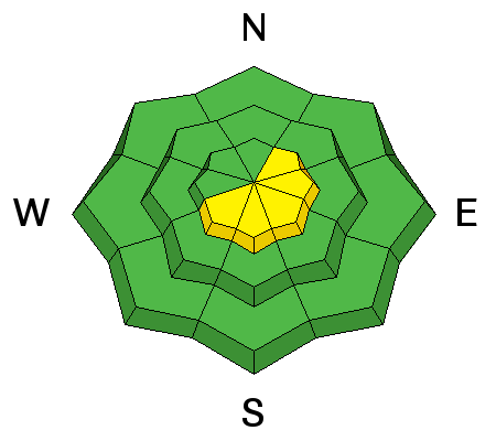
As the northwest winds picked up in the overnight hours this has created fresh drifts of wind blown snow on the upper elevation northeast through southwest facing terrain. Watch for any fresh drifts of wind blown snow and avoid rounded pillowy looking snow. |
 |
weather As the storm exits to our east it will make way for mostly sunny skies today and tomorrow ahead of another storm that moves into the region on Thursday. Today temperatures will climb into the mid 30's at 9000' feet. Winds will remain from the north and blow 15-25 mph with gusts into the 30's. Thursday's storm will bring roughly 6" inches of new snow Thursday night into Friday. Unfortunately, the way it sits now - it's on track to spin towards the four corners. This means that it will have a greater impact on the central to southern half of the state. This will also cause the dreaded east winds to pick up and wreak havoc to the powder snow on Friday. It's not looking good. (hopefully myself and Glen from the National Weather service is wrong). |
| general announcements Remember your information can save lives. If you see anything we should know about, please help us out by submitting snow and avalanche conditions. You can also call us at 801-524-5304, email by clicking HERE, or include #utavy in your tweet or Instagram. To get help in an emergency (to request a rescue) in the Wasatch, call 911. Be prepared to give your GPS coordinates or the run name. Dispatchers have a copy of the Wasatch Backcountry Ski map. Backcountry Emergencies. It outlines your step-by-step method in the event of a winter backcountry incident. If you trigger an avalanche in the backcountry, but no one is hurt and you do not need assistance, please notify the nearest ski area dispatch to avoid a needless response by rescue teams. Thanks.
EMAIL ADVISORY If you would like to get the daily advisory by email you will need to subscribe here. DAWN PATROL Hotline updated daily by 5-530am - 888-999-4019 option 8. TWITTER Updates for your mobile phone - DETAILS UDOT canyon closures: LINK TO UDOT, or on Twitter, follow @UDOTavy, @CanyonAlerts or @AltaCentral Utah Avalanche Center mobile app - Get your advisory on your iPhone along with great navigation and rescue tools. Powderbird Helicopter Skiing - Blog/itinerary for the day Lost or Found something in the backcountry? - http://nolofo.com/ To those skinning uphill at resorts: it is critical to know the resort policy on uphill travel. You can see the uphill travel policy for each resort here. Benefit the Utah Avalanche Center when you shop from Backcountry.com or REI: Click this link for Backcountry.com or this link to REI, shop, and they will donate a percent of your purchase price to the UAC. Both offer free shipping (with some conditions) so this costs you nothing! Benefit the Utah Avalanche Center when you buy or sell on ebay - set the Utah Avalanche Center as a favorite non-profit in your ebay account here and click on ebay gives when you buy or sell. You can choose to have your seller fees donated to the UAC, which doesn't cost you a penny. This information does not apply to developed ski areas or highways where avalanche control is normally done. This advisory is from the U.S.D.A. Forest Service, which is solely responsible for its content. This advisory describes general avalanche conditions and local variations always occur |


