25th Annual Black Diamond Fall Fundraising Party
Thursday, September 13; 6:00-10:00 PM; Black Diamond Parking Lot
25th Annual Black Diamond Fall Fundraising Party
Thursday, September 13; 6:00-10:00 PM; Black Diamond Parking Lot
| Advisory: Ogden Area Mountains | Issued by Paige Pagnucco for Friday - March 24, 2017 - 6:07am |
|---|

|
bottom line The avalanche danger is MODERATE today for triggering wet loose sluffs on steep slopes. Avoid travel on or underneath any steep slopes showing signs of warming induced instability. Isolated wind slabs are also a concern in upper elevation terrain. Lower angle slopes at the upper and mid elevations should have good turning and riding conditions in the new dense snow.
|
 |
special announcement “I try to do the right thing at the right time. They may just be little things, but usually they make the difference between winning and losing.” - Kareem Abdul Jabbar Be sure to check out the last installment of the The Little Things - habits that might keep you alive, a four part series of tricks and tidbits to help keep you on top picked up by one of our observers during years of mostly incident-free wandering in the backcountry by ski, foot, and boat. |
 |
current conditions Yesterday's storm delivered a nice refresher - the Ogden area mountains picked up 10"-14" of fairly dense spring snow. If you get out early today, before the sun and warm temps take hold, you might be rewarded with some decent conditions. Though the new snow is slightly heavy, riding was surprisingly good yesterday above 7500'. The cooler overnight and morning temps will help to preserve the snow for a little while. Overnight temperatures dropped into the mid to lower 20's F with current temps near 25 F at 8000'. Winds were northerly for the past day or so but will shift to the south today and blow 5-10 mph with rigdetop gusts a bit higher.
Skinning was character building yesterday. |
 |
recent activity No new avalanches have been reported. Observers note good bonding of the new snow to the existing wet snow surface. Pushalanches were possible on steeper slopes and a few sensitive new snow slabs were observed in mid elevation terrain.
The new snow is bonding well to the very warm and wet old snow surface. |
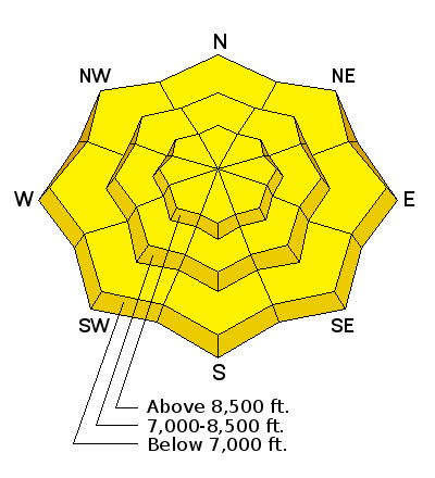
| type | aspect/elevation | characteristics |
|---|

|
|
LIKELIHOOD
 LIKELY
UNLIKELY
SIZE
 LARGE
SMALL
TREND
 INCREASING DANGER
SAME
DECREASING DANGER
|
|
description
It actually froze last night after over a week of above freezing overnight temperatures. The good news is that will preserve the new snow for a bit longer into today. The bad news is the existing warm and wet snowpack is now insulated from any real effects of the cold temps. It's going to take many refreezes to penetrate deep into the pack and restore some stability. With clear skies today, the new snow could become reactive, especially on slopes affected by direct sunlight. Wet loose sluffs or perhaps even wet slabs might be triggered today on steep slopes of all aspects and elevations once they get damp and saturated. Your best bet is to enjoy the new snow before it gets hit by the sun. Move off of steep slopes when the snow gets damp and you see signs of instability like rollerballs. |
| type | aspect/elevation | characteristics |
|---|

|
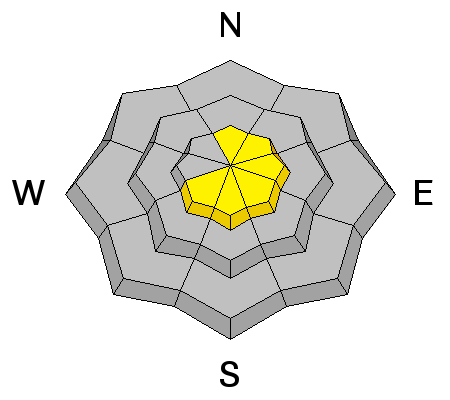
|
LIKELIHOOD
LIKELY
UNLIKELY
SIZE
LARGE
SMALL
TREND
INCREASING DANGER
SAME
DECREASING DANGER
|
|
description
Cornices: Signs of failing cornice like cracks will be hidden beneath the new snow today and hard to identify. Avoidance is key – don’t travel beneath cornices and stay well back from the edges. Cornices tend to break well back onto what looks like flat terrain. Glide cracks are open and are in terrain near Rodeo Ridge and Ben Lomond. Like cornices, they might be harder to see today. They are most common where there are smooth rock slabs or grass beneath the snow. Try to avoid travel below these cracks and stay out of their run out zones. |
| type | aspect/elevation | characteristics |
|---|

|
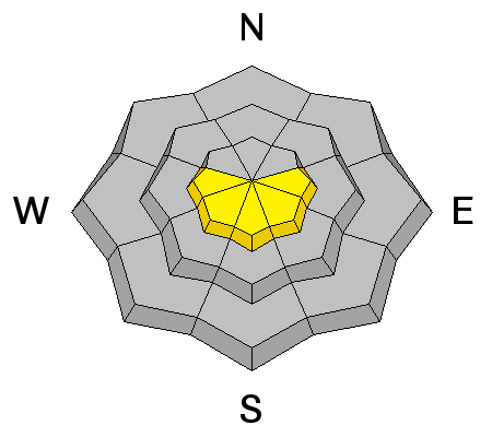
|
LIKELIHOOD
 LIKELY
UNLIKELY
SIZE
LARGE
SMALL
TREND
 INCREASING DANGER
SAME
DECREASING DANGER
|
|
description
Yesterday's northerly winds created fresh wind drifts in upper elevation terrain. Though the new snow has bonded well to the existing snow surface, there is a chance you can trigger isolated wind slabs in steep, exposed terrain. |
 |
weather It'll be a "bluebird" day in the Ogden zone with sunshine on tap and mountain temps reaching just into the 40's F. Southerly winds are forecast to blow 5-10 mph. Enjoy the beautiful weather today as a small storm is on tap for late tonight into tomorrow bringing another shot of snow and wintery conditions. |
general announcements
|


_0.jpg)