25th Annual Black Diamond Fall Fundraising Party
Thursday, September 13; 6:00-10:00 PM; Black Diamond Parking Lot
25th Annual Black Diamond Fall Fundraising Party
Thursday, September 13; 6:00-10:00 PM; Black Diamond Parking Lot
| Advisory: Ogden Area Mountains | Issued by Drew Hardesty for Monday - March 20, 2017 - 6:41am |
|---|

|
bottom line The danger for wet activity will rise to at least MODERATE today. Natural and human triggered wet avalanches are likely on a variety of aspects and elevations. The best and safest conditions are on smooth, undisturbed low angle slopes. Cornices remain significant objective hazards and glide avalanches are possible in glide crack-littered terrain.
|
 |
special announcement Spring Special: We have a few donated Snowbasin discount lift tickets left and have just lowered the price. Ski a day and benefit the Utah Avalanche Center! Order here. |
 |
current conditions Happy Equinox. In case you didn't know it, we started spring a couple weeks ago. Skies are mostly cloudy. Winds are southwesterly, blowing 15mph with gusts to 25. Temperatures are in the mid to upper 40s. Ogden skyline winds are blowing from the southwest at 15mph with gusts to 30. |
 |
recent activity Already this morning: Some natural wet sluffs were reported at 530am this morning in steep south facing terrain above Little Cottonwood Canyon. Activity yesterday centered on three main issues:
(Natural cornice fall from early Sunday morning, credit: Achelis) |
| type | aspect/elevation | characteristics |
|---|

|

|
LIKELIHOOD
 LIKELY
UNLIKELY
SIZE
 LARGE
SMALL
TREND
 INCREASING DANGER
SAME
DECREASING DANGER
|
|
description
A thin blanket of overnight clouds and continued warm temperatures will keep wet point release sluffs high on the avalanche problem list for today. Sure, they don't have the speed of their dry cousins, but they more than make up for it with sheer mass, volume, and pound-for-pound, destructive potential. Wet loose sluffs can be triggered today on all aspects and elevations except the highest, northerly facing slopes. Keep an eye on the snow surface, when it becomes damp, punchy, and unsupportable - it's time to leave or move to low angle slopes. The outlier: free water pooling above the any number of crusts, especially the February rain crusts, may produce wet slab activity in steep terrain. Control work two days ago produced a 3' deep wet slab in unsupported terrain. |
| type | aspect/elevation | characteristics |
|---|

|

|
LIKELIHOOD
LIKELY
UNLIKELY
SIZE
 LARGE
SMALL
TREND
 INCREASING DANGER
SAME
DECREASING DANGER
|
|
description
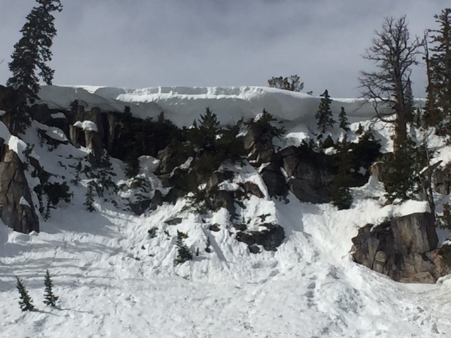
It's calving season. More and more cornices are calving off the ridgelines, leaving enormous piles of snow in the runout zones. We've had a few very close calls recently with cornices. Stay well back from the ridgelines and run-don't-walk if moving in terrain beneath the giant whales. |
| type | aspect/elevation | characteristics |
|---|
|
|
LIKELIHOOD
 LIKELY
UNLIKELY
SIZE
LARGE
SMALL
TREND
INCREASING DANGER
SAME
DECREASING DANGER
|
|
description
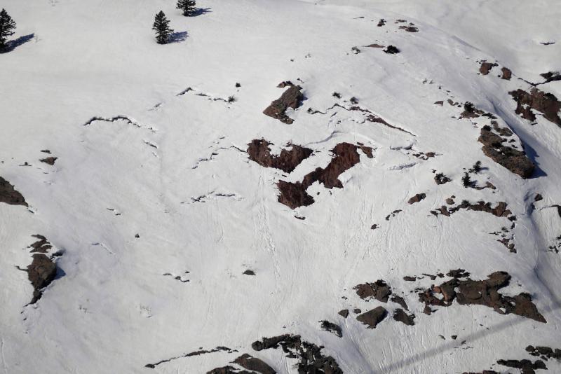
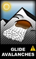
Glide cracks are opening throughout the range and occur primarily where there are smooth rock slabs beneath the snow. Appropriate risk-management strategies include avoiding all terrain with glide cracks or recent glide releases and giving runout zones a wide berth. Paige found many glide cracks in the Ben Lomond area the other day, photo below
|
 |
weather We'll have mostly cloudy skies, moderate southwest winds, and daytime highs reaching into the low 40s along the ridgelines and to near 60°F at 8500'. Some convective showers with lightning is possible this afternoon. A warm and windy storm on a southerly flow will embrace the state Wednesday evening into Thursday. A foot of snow may be expected in the higher elevations with a rain/snow line perhaps initially at 8000'...dropping to 7000' by Thursday as the flow shifts from southerly to west/northwest. We get a quick break Friday ahead of the next system on Saturday. |
| general announcements Remember your information can save lives. If you see anything we should know about, please help us out by submitting snow and avalanche conditions. You can also call us at 801-524-5304, email by clicking HERE, or include #utavy in your tweet or Instagram. To get help in an emergency (to request a rescue) in the Wasatch, call 911. Be prepared to give your GPS coordinates or the run name. Dispatchers have a copy of the Wasatch Backcountry Ski map. Backcountry Emergencies. It outlines your step-by-step method in the event of a winter backcountry incident. If you trigger an avalanche in the backcountry, but no one is hurt and you do not need assistance, please notify the nearest ski area dispatch to avoid a needless response by rescue teams. Thanks.
EMAIL ADVISORY If you would like to get the daily advisory by email you will need to subscribe here. DAWN PATROL Hotline updated daily by 5-530am - 888-999-4019 option 8. TWITTER Updates for your mobile phone - DETAILS UDOT canyon closures: LINK TO UDOT, or on Twitter, follow @UDOTavy, @CanyonAlerts or @AltaCentral Utah Avalanche Center mobile app - Get your advisory on your iPhone along with great navigation and rescue tools. Powderbird Helicopter Skiing - Blog/itinerary for the day Lost or Found something in the backcountry? - http://nolofo.com/ To those skinning uphill at resorts: it is critical to know the resort policy on uphill travel. You can see the uphill travel policy for each resort here. Benefit the Utah Avalanche Center when you shop from Backcountry.com or REI: Click this link for Backcountry.com or this link to REI, shop, and they will donate a percent of your purchase price to the UAC. Both offer free shipping (with some conditions) so this costs you nothing! Benefit the Utah Avalanche Center when you buy or sell on ebay - set the Utah Avalanche Center as a favorite non-profit in your ebay account here and click on ebay gives when you buy or sell. You can choose to have your seller fees donated to the UAC, which doesn't cost you a penny. This information does not apply to developed ski areas or highways where avalanche control is normally done. This advisory is from the U.S.D.A. Forest Service, which is solely responsible for its content. This advisory describes general avalanche conditions and local variations always occur. |