25th Annual Black Diamond Fall Fundraising Party
Thursday, September 13; 6:00-10:00 PM; Black Diamond Parking Lot
25th Annual Black Diamond Fall Fundraising Party
Thursday, September 13; 6:00-10:00 PM; Black Diamond Parking Lot
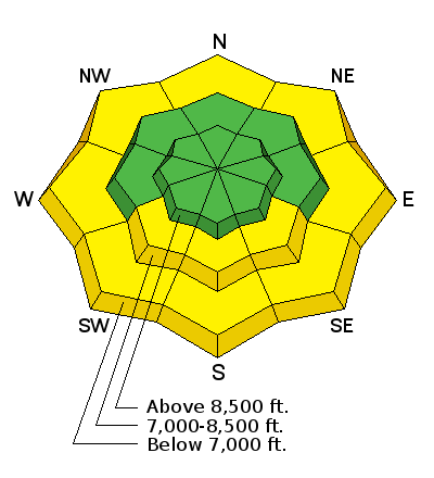
| Advisory: Ogden Area Mountains | Issued by Trent Meisenheimer for Sunday - March 12, 2017 - 6:26am |
|---|

|
bottom line The avalanche danger is LOW this morning on all aspects and elevations. However, as the sun comes out in the afternoon and the wind speeds decrease, the avalanche danger will quickly rise to MODERATE on mid to low elevation south and northerly aspects for wet loose avalanches.
|
 |
special announcement Spring Special: We have a few donated Snowbird, Snowbasin, Solitude, and Brighton discount lift tickets left and have just lowered the price. Ski a day and benefit the Utah Avalanche Center! Order here. |
 |
current conditions This morning under partly cloudy skies, temperatures are still on the warm side. Most upper elevation stations are hovering just above freezing - 32 degrees.. Mid canyon temperatures are in the mid to upper thirties. With clear skies overnight many stations dipped just under 32 degrees, and the snow surface will be crusted this morning. Westerly winds picked up around 8:00 pm last night and on Ogden peak they are currently blowing 25 mph with gusts into the 40's. Lower elevation stations are reporting speeds of 15-20 mph with gusts into the upper 20's. I don't think the south facing slopes will soften enough today for good corn conditions due to the clouds, wind and cooling temperatures. There are scraps of soft settled powder on the highest due north facing slopes. |
 |
recent activity Wet loose avalanches occurred predictably yesterday as warm temperatures and sunshine heated the snow surface. Video of a wet avalanche that happened yesterday during the heat of the day. |
| type | aspect/elevation | characteristics |
|---|

|
|
LIKELIHOOD
 LIKELY
UNLIKELY
SIZE
 LARGE
SMALL
TREND
 INCREASING DANGER
SAME
DECREASING DANGER
|
|
description
Overnight temperatures didn't get quite as cold as I would of liked. Many mid to lower elevations did not get a solid re-freeze and that's why there is a MODERATE avalanche danger for wet loose avalanches at the lower elevations. At the upper elevations the wind, clouds and cooler temperatures should keep the snow surfaces crusted over - keeping our wet loose avalanche problem at bay. However, if the forecast is wrong and the March sun intensifies expect rapidly changing avalanche conditions on the sunny aspects. This time of year a south facing slope can be perfectly safe and in a matter of an hour it can become unstable. The key to avoiding these types of avalanches is timing. Most days the cycle for wet snow goes like this:
The timing of this cycle varies by slope through the day with east aspects experiencing it first and west aspects experiencing it last. Loose wet avalanches can occur on northerly aspects as well at low elevations or near rock bands and cliffs. |
| type | aspect/elevation | characteristics |
|---|

|
|
LIKELIHOOD
LIKELY
UNLIKELY
SIZE
LARGE
SMALL
TREND
 INCREASING DANGER
SAME
DECREASING DANGER
|
|
description
Enormous cornices along the ridge lines are more likely to release with warm temperatures at any time of day or night. Stay way back from the edges of the cornices and minimize any time spent beneath these monsters.
|
 |
weather Yesterday's bump in wind speeds ushered in a very weak cold front this morning. By the time many of you will read this the bulk of the storm will have already passed. High clouds will continue to stream overhead as the northwest winds continue to blow for much of the day. Temperatures will cool slightly today and this evening leading to a solid refreeze of the snow pack. High pressure quickly builds back in on Monday and the blue bird will sing again. |
general announcements
|


.jpg)