25th Annual Black Diamond Fall Fundraising Party
Thursday, September 13; 6:00-10:00 PM; Black Diamond Parking Lot
25th Annual Black Diamond Fall Fundraising Party
Thursday, September 13; 6:00-10:00 PM; Black Diamond Parking Lot
| Advisory: Ogden Area Mountains | Issued by Paige Pagnucco for Friday - March 10, 2017 - 6:15am |
|---|


|
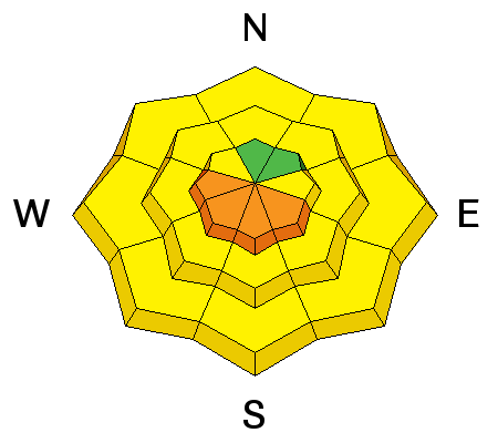
bottom line The avalanche danger will rise to MODERATE AND POSSIBLY CONSIDERABLE for wet loose sluffs today. Wet activity will occur first on east then south then west facing slopes as well as mid and low elevation north facing slopes. As the temperature increases, natural wet loose avalanches might occur - when you experience signs of instability like dampening snow and rollerballs, it'll be time to avoid steep slopes and the run out zones below.
|
 |
special announcement Spring Special: We have a few donated Snowbird, Snowbasin, Solitude, and Brighton discount lift tickets left and have just lowered the price. Ski a day and benefit the Utah Avalanche Center! Order here. The Wasatch Powderkeg will be held Friday and Saturday, Mar 10 and 11, at Brighton as a benefit for the Utah Avalanche Center, featuring a Ski Mountaineering Sprint race on Friday afternoon and a longer race Saturday with Race, recreation, and youth courses and divisions. There will also be Companion Rescue, Terrain Strategies, Splitboarding, Steep Skiing and Riding, and Mountaineering Techniques for Skiers and Snowboarders skills clinics Saturday taught by local pros. There will be a drawing for great gear including boots and winner's choice of skis or a splitboard mid-day Saturday. Details here. |
 |
current conditions Temperatures this morning are mild in the Ogden zone - Ben Lomond (8000') is a balmy 43 F, Monte Cristo (8960') is 37 F, and Parrish Creek (7740') is 42 F. Winds are 10-15 mph out of the southwest with ridgetop speeds gusting in the 25-35 mph range. Skies are mostly cloudy. Snow surface conditions run the gamut - from quasi-corn to wind buff to sloppy to supportable, depending on your locale. High elevation north is the last holdout but even today's warm temps and cloudy skies may adversely affect whatever "dry" snow remains. |
 |
recent activity Observers noted significant rollerballing as well as a few wet loose sluffs on steep sun affected slopes yesterday. |
| type | aspect/elevation | characteristics |
|---|

|
|
LIKELIHOOD
 LIKELY
UNLIKELY
SIZE
 LARGE
SMALL
TREND
 INCREASING DANGER
SAME
DECREASING DANGER
|
|
description
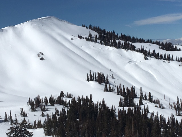
Same story as yesterday - temperatures though are supposed to be even a few degrees warmer. With a poor overnight refreeze, the snow will already be sloppy and transition quickly to wet and sloppy as the day heats up. Wet loose sluffs will be easy to trigger and natural wet loose avalanches are possible. Avalanches will start first on east facing slopes, then south and then west. With cloud cover creating potential "green-housing", mid and low elevation north facing slopes will also succumb to the heat and dampen quickly. Any wet loose slides may run further than expected and entrain more snow on their downward journey. Watch for predictable signs - dampening snow, roller balls and small sluffs, often initiating off rocks and cliff bands. When you see these warning signs it’s time to head to lower angle slopes or a different, cooler aspect. When spring arrives and temps are warm, we begin to see glide cracks. Though these typically move and open slowly, it's best to give them a wide berth as it can be hard to determine their edges.
Glide crack in Willard Basin. pc: Hardesty |
| type | aspect/elevation | characteristics |
|---|

|

|
LIKELIHOOD
 LIKELY
UNLIKELY
SIZE
LARGE
SMALL
TREND
INCREASING DANGER
SAME
DECREASING DANGER
|
|
description
Enormous cornices along the ridge lines are more likely to release with warm temperatures and can release around the clock. Avoidance is the key - stay way back from the edges of the cornices and minimize any time spent beneath these monsters.
|
 |
weather There's a chance for rain/snow today but it won't amount to much, maybe a trace - 1". With the air as warm as it is, it's likely we'll see more rain than snow. Temperatures will be very warm again, near 45 F at 8000', and skies will be mostly cloudy. Winds will blow 10-15 mph out of the southwest, then west, and then northwest by tonight as the weather front moves through. Besides a very small disturbance on Sunday, high pressure and spring-like weather will be the theme for the coming week. |
general announcements
|


.jpg)