25th Annual Black Diamond Fall Fundraising Party
Thursday, September 13; 6:00-10:00 PM; Black Diamond Parking Lot
25th Annual Black Diamond Fall Fundraising Party
Thursday, September 13; 6:00-10:00 PM; Black Diamond Parking Lot
| Advisory: Ogden Area Mountains | Issued by Trent Meisenheimer for Sunday - March 5, 2017 - 6:53am |
|---|


|
bottom line The avalanche danger is MODERATE today for increasingly widespread hard wind drifts that can be triggered by a person. The wind slabs will be most widespread on mid and upper elevation slopes, especially those facing northwest through easterly. LOWER danger terrain would be wind sheltered, shady slopes at the mid and upper elevations, with no steep wind drifted slopes above you.
|
 |
current conditions Today's winds are tomorrow's powder day. Another Utah classic cold front is on our doorstep. Like the great Bob Dylan said " You don't need a weatherman to know which way the wind blows." Just step outside and take a look. Upper elevation winds are averaging 30-40 mph gusting into the 60's and 70's. Even the more sheltered wind stations are picking up speeds of 20-30 mph with gusts into the 50's. Temperatures will remain warm today ahead of the cold front - current upper elevation temps are in the upper 20's and mid to lower canyon temperatures are above freezing. The snow surface is a myriad of different textures - sun and wind crusts galore, even the mid elevation north facing slopes up to 8800' got damp with yesterday's strong solar rays and warm temperatures. If you're looking for powder it's probably best to work on taxes today and cash in on the goods tomorrow.
|
 |
recent activity Yesterday backcountry enthusiasts reported wind slab development on all aspects and elevations above 8000'. In the Central Wasatch a party in Hogum fork was climbing a steep east facing line when one person triggered a small wind slab and was caught and carried 300' feet downhill in the avalanche. He was not injured. No other avalanche activity was reported yesterday. |
| type | aspect/elevation | characteristics |
|---|

|
|
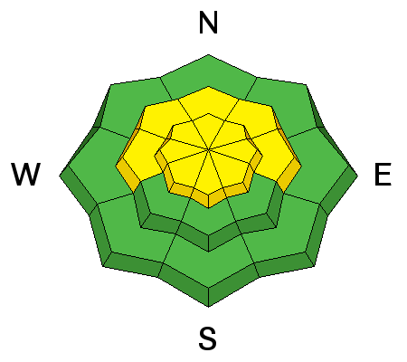
LIKELIHOOD
 LIKELY
UNLIKELY
SIZE
 LARGE
SMALL
TREND
 INCREASING DANGER
SAME
DECREASING DANGER
|
|
description
Southerly winds will continue wreaking havoc to the snow surface today. You can expect widespread new and old wind slabs, both along mid and upper elevation ridge lines. The swirly winds will also push down into open bowls and the rolling terrain in the mountain drainages. I would expect these slabs to be stiff and stubborn today. Although, you wouldn't find me messing with upper elevation wind loaded terrain. Look for and avoid these hard smooth slabs on any steep slope. Video of winds: by Greg Gagne - yesterday in Maybird Gulch in Little Cottonwood Canyon. |
| type | aspect/elevation | characteristics |
|---|

|
|
LIKELIHOOD
LIKELY
UNLIKELY
SIZE
 LARGE
SMALL
TREND
INCREASING DANGER
SAME
DECREASING DANGER
|
|
description
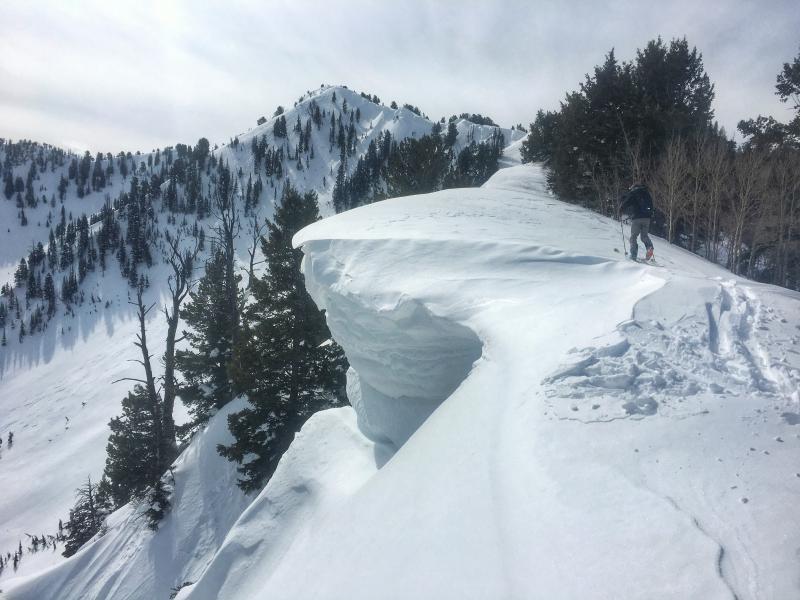
According to the Chinese zodiac - 2017 is the year of the rooster. However, I would argue that it's the year of the cornice. These things are MASSIVE... and it's terrifying walking on ridge lines where you can't see over the edge. At times you wonder if you're walking on the ground or hanging off the edge of the world. Give these yawning giants a wide berth and never approach an edge without knowing for sure, that it's not overhanging. Photo of: Drew Hardesty giving respect to a massive cornice in Alexander Basin in Millcreek Canyon yesterday.
|
 |
weather Windy and warm today as a powerful cold front approaches us from the north. Places favored by the southwest winds could see gusts to 110 mph later this afternoon with a chance of thunder. Sometime around the dinner hour the cold air will arrive and the winds of tide will diminish, shift to the north and it will begin to snow. This powerful system will bring heavy snow to the mountains of northern Utah. Snowfall rates of 2-3" per hour are expected and will be the strongest from 7:00-11:00 pm tonight. Total forecasted snow: 14-22'' (0.85-1.15" h20). |
general announcements
|