25th Annual Black Diamond Fall Fundraising Party
Thursday, September 13; 6:00-10:00 PM; Black Diamond Parking Lot
25th Annual Black Diamond Fall Fundraising Party
Thursday, September 13; 6:00-10:00 PM; Black Diamond Parking Lot
| Advisory: Ogden Area Mountains | Issued by Paige Pagnucco for Saturday - March 4, 2017 - 6:59am |
|---|

|
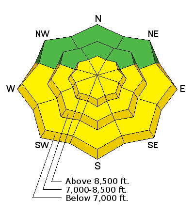
bottom line The avalanche danger is generally LOW but will again rise to MODERATE on all steep sunlit slopes with daytime warming. The steep east to south to west facing terrain is to be avoided by the time it becomes damp and unstable, usually in the mid-morning to mid-afternoon hours. Cornices are still huge - take particular care along and beneath cornice-littered ridgelines.
|
 |
special announcement New guest blog by Tom Diegel - The Little Things (that might keep you alive) - Part I |
 |
current conditions Mountain temperatures are in the low 30's and winds are blowing strong out of the south southwest with ridgetop gusts already nearing 50+ mph. The sun did more damage yesterday as temps rose and dampened the snow on southeast through west facing slopes. You'll again find crusts of varying thickness on these aspects this morning. Wind has also damaged the surface snow in exposed areas. Your best bet still for finding soft, settled, cold powder snow is on north facing sheltered terrain at the mid and upper elevations. |
 |
recent activity No recent avalanches have been reported in the Ogden area mountains. One skier in the Cottonwoods got lucky yesterday after getting knocked down by a small wet avalanche in the Y Not couloir. A good reminder to always pay attention to what's above you. |
| type | aspect/elevation | characteristics |
|---|

|
|
LIKELIHOOD
 LIKELY
UNLIKELY
SIZE
 LARGE
SMALL
TREND
 INCREASING DANGER
SAME
DECREASING DANGER
|
|
description
With even warmer temperatures forecast today, any direct sun and warm temperatures will again dampen and loosen the snow on steep sunlit aspects especially in areas where there was a poor overnight refreeze. Rollerballs and natural wet sluffs are key indicators that the snow is becoming saturated and unstable. Avoid being on or underneath steep slopes once the snow gets damp and gloppy. Move onto shaded slopes ahead of the effects of rapid warming to avoid this problem. |
| type | aspect/elevation | characteristics |
|---|

|
|
LIKELIHOOD
LIKELY
UNLIKELY
SIZE
 LARGE
SMALL
TREND
 INCREASING DANGER
SAME
DECREASING DANGER
|
|
description
Cornices are enormous. They may break off on approach and break back well beyond the apex of the ridgeline. Avoid being on or beneath these gigantic whales of snow. With strong, gusty winds forecast for today, look for and avoid fresh, hard wind drifts on steep slopes. These will build today and, being stubborn in nature, may allow you to get out on them before releasing. |
| type | aspect/elevation | characteristics |
|---|

|
|
LIKELIHOOD
 LIKELY
UNLIKELY
SIZE
 LARGE
SMALL
TREND
 INCREASING DANGER
SAME
DECREASING DANGER
|
|
description
Just a friendly reminder to continue to use safe travel protocols when traveling in avalanche terrain. Also, if snow conditions aren't what you were expecting, spend a few minutes doing a beacon search practice. It's a great way to test you and your partners skills as well as have an excuse to stay outside. |
 |
weather In the Ogden area mountains today, it'll be warm with highs in the 40's and breezy south southwest winds blowing 20-30 mph with gusts much higher in exposed terrain. The "warm before the storm" so to speak as a strong and productive winter storm is set to arrive Sunday afternoon. Monday might be a good day to catch a fever and call in sick with snowfall totals forecast to be 1 to 2 feet. |
general announcements
|


