25th Annual Black Diamond Fall Fundraising Party
Thursday, September 13; 6:00-10:00 PM; Black Diamond Parking Lot
25th Annual Black Diamond Fall Fundraising Party
Thursday, September 13; 6:00-10:00 PM; Black Diamond Parking Lot
| Advisory: Ogden Area Mountains | Issued by Drew Hardesty for Thursday - March 2, 2017 - 6:58am |
|---|

|
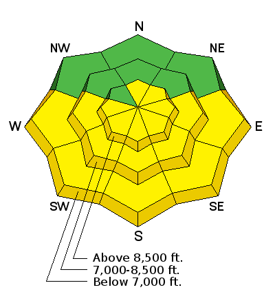
bottom line The avalanche danger will rise to the high end of MODERATE on all steep sunlit slopes with daytime warming. The steep east to south to west facing terrain is to be avoided by the time it becomes damp and unstable, usually in the mid-morning to mid-afternoon hours. Pockets of MODERATE exist for lingering wind drifts in the steep exposed alpine terrain. Cornices have become gargantuan and unruly - take particular care along and beneath cornice-littered ridgelines.
|
 |
special announcement New guest blog by Tom Diegel - The Little Things (that might keep you alive) - Part I |
 |
current conditions Skies are clear. Winds are west to northwesterly, blowing 15-20mph. Mountain temperatures are in the teens. Despite some wind damage in the open, exposed terrain, riding conditions are A+ and coverage is excellent. Look for a new crop of surface hoar feathers shimmering in the light above yesterday's snow surface. Some south and westerly aspects will sport a breakable crust this morning that will soften with daytime warming. Check out a couple of yesterday's observations by Evelyn and Kory Davis here. |
 |
recent activity Despite the strong westerly winds Tuesday night into early Wednesday, avalanche work only resulted in a few explosive and cornice triggered wind slabs exclusive to the high alpine cirques. Stability rapidly improved over the course of the day. |
| type | aspect/elevation | characteristics |
|---|

|
|
LIKELIHOOD
 LIKELY
UNLIKELY
SIZE
 LARGE
SMALL
TREND
 INCREASING DANGER
SAME
DECREASING DANGER
|
|
description
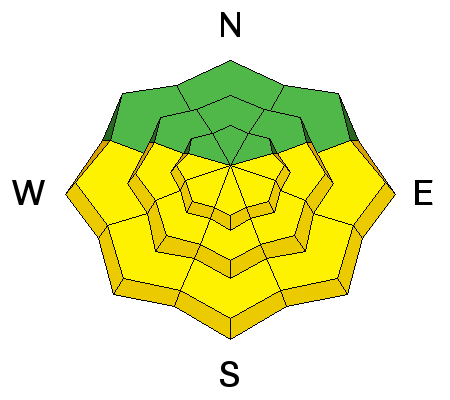
Direct sun and warming will conspire to dampen and loosen the snow on the steep sunlit aspects today. Rollerballs and natural sluffs are key indicators that the snow is becoming saturated and unstable. The most problematic situation will be in the mid-morning to afternoon hours in the steepest, most confined terrain where enough loose wet snow may gouge down to Sunday's slick melt-freeze crust and entrain significant amounts of snow. These steep sun-drenched slopes should become active over the next few days... Know that avoidance of wet avalanche issues come down to place and time. For example - enjoy the east facing terrain in the early morning and then move to other, cooler aspects before they heat up. As with most things in life, timing is everything. |
| type | aspect/elevation | characteristics |
|---|

|
|
LIKELIHOOD
 LIKELY
UNLIKELY
SIZE
LARGE
SMALL
TREND
 INCREASING DANGER
SAME
DECREASING DANGER
|
|
description
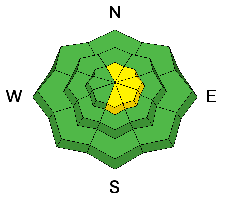
Lingering, isolated pockets of wind slab may be still be triggered in steep locations in the alpine, particularly after they've enjoyed the direct sun and rapid warming. These pockets may be 12-20" deep and predominantly found on north to east to south facing slopes. |
| type | aspect/elevation | characteristics |
|---|

|
|
LIKELIHOOD
LIKELY
UNLIKELY
SIZE
 LARGE
SMALL
TREND
INCREASING DANGER
SAME
DECREASING DANGER
|
|
description
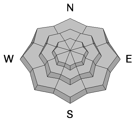
Cornices are enormous. They may break off on approach and break back well beyond the apex of the ridgeline. Longtime observer Brian Smith in Ogden said it best - "it is difficult to tell where the earth ends and the snow begins." Avoid being on or beneath these gigantic whales of snow. |
 |
weather We'll have mostly sunny skies, light westerly winds and daytime highs reaching to near 40°F at 8500'. The warming trend will continue into the weekend with the next storm system slated for later Sunday into Monday. |
general announcements
|


