25th Annual Black Diamond Fall Fundraising Party
Thursday, September 13; 6:00-10:00 PM; Black Diamond Parking Lot

25th Annual Black Diamond Fall Fundraising Party
Thursday, September 13; 6:00-10:00 PM; Black Diamond Parking Lot
| Advisory: Ogden Area Mountains | Issued by Drew Hardesty for Wednesday - March 1, 2017 - 7:11am |
|---|
 |
special announcement New guest blog by Tom Diegel - The Little Things (that might keep you alive) - Part I |
 |
current conditions Just putting the finishing touches on the current storm system...and skies are trending partly cloudy. Mountain temperatures are in the single digits and low teens. Winds, however, play the spoiler. Overnight west-northwest winds blew 25-30mph with gusts to 45. The most exposed anemometers averaged 35-50mph with gusts to 70. They've lost some steam the last couple of hours, but the damage is irreconcilably done. Overnight snowfall amounts are just an inch of new, but the storm totals since late Sunday/early Monday are 20-28". |
 |
recent activity Reported avalanche activity yesterday was minor in scope, with loose snow sluffing and isolated wind slabs in very exposed terrain. A few cornices along the exposed ridgelines became unhinged and triggered either shallow drifts or minor dry sluffs. |
| type | aspect/elevation | characteristics |
|---|


|


|

LIKELIHOOD
 LIKELY
UNLIKELY
SIZE
 LARGE
SMALL
TREND
 INCREASING DANGER
SAME
DECREASING DANGER
|
|
description
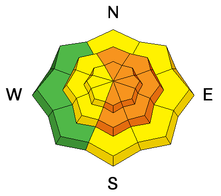
Drifting should be widespread and not limited to the upper elevations. Wind drifts are often smooth and rounded, stiff and chalky and you'll instantly notice that it's not the world-class blower powder anymore if you transition to wind drifted terrain. Even the mid-elevation anemometers couldn't hide from the wind. Drifts may exceed two feet in heavily drifted terrain, with drifts likely well off the ridgelines and cross-loaded beyond sub-ridges and rocky outcrops. They'll need a couple days to stabilize. Consider shooting cracks and audible collapsing of wind pillows to be sure signs of instability. |
| type | aspect/elevation | characteristics |
|---|


|


|

LIKELIHOOD
 LIKELY
UNLIKELY
SIZE
 LARGE
SMALL
TREND
 INCREASING DANGER
SAME
DECREASING DANGER
|
|
description
A couple of notes for today -
|
| type | aspect/elevation | characteristics |
|---|


|


|

LIKELIHOOD
 LIKELY
UNLIKELY
SIZE
 LARGE
SMALL
TREND
 INCREASING DANGER
SAME
DECREASING DANGER
|
|
description
Cornices are enormous. They may break off on approach and break back well beyond the apex of the ridgeline. Longtime observer Brian Smith in Ogden said it best - "it is difficult to tell where the earth ends and the snow begins." Avoid being on or beneath these gigantic whales of snow. |
 |
weather Skies will continue to trend partly cloudy in the wake of the storm. 8500' temps will reach to the low 20s. West to northwest winds will blow 15-20mph with gusts to 30. Skies will start to clear overnight as weak high pressure builds into the area over the next few days. The next storm system arrives Sunday. Details to follow. |
general announcements
|