25th Annual Black Diamond Fall Fundraising Party
Thursday, September 13; 6:00-10:00 PM; Black Diamond Parking Lot
25th Annual Black Diamond Fall Fundraising Party
Thursday, September 13; 6:00-10:00 PM; Black Diamond Parking Lot
| Advisory: Ogden Area Mountains | Issued by Evelyn Lees for Sunday - February 26, 2017 - 6:49am |
|---|

|
bottom line The avalanche danger is mostly LOW this morning, but will quickly increase to MODERATE as winds pick up this afternoon, and could reach CONSIDERABLE along the highest ridge lines by evening. Once the fresh wind drifts start to form, stay off of and out from under steep wind drifted slopes. Finish your powder day on wind-sheltered slopes.
|
 |
special announcement The CAIC finished their report on the recent snowbike fatality. It's a story worth reading. It was a complex situation, with 3 separate avalanches occurring. A take home is they had airbags and didn't think they needed beacons. A beacon, probe, and shovel are still essential gear, even with an air bag. |
 |
current conditions You can squeeze in one more epic morning of powder, before increasing winds this afternoon spike the avalanche danger. The storm has never really ended in the Ogden area mountains, with the resorts reporting an additional 6 to 8" over the past 24 hours, with storm totals right around 50" now. Skies mostly clear this morning, and temperatures powder-preserving cold – in the single digits to low teens. The winds cooperated, remaining light overnight, and Ogden wind stations averaging less than 1s mph from the southwest this morning. Mt Ogden is not working again. |
 |
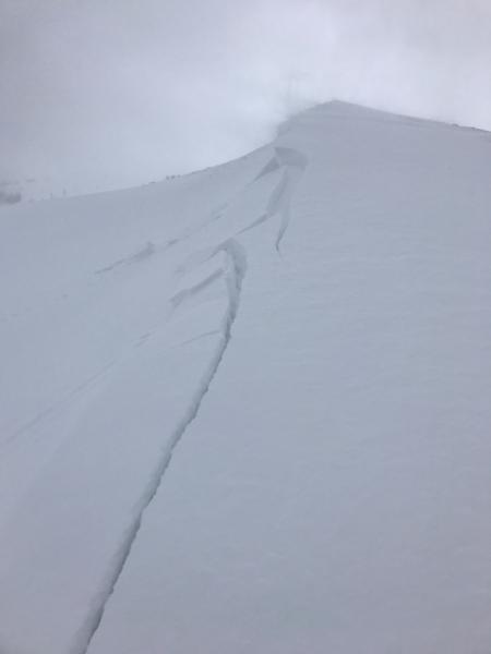
recent activity In the windier Ogden area mountains, speeds bumped up briefly in the afternoon, and a few shallow soft slabs were reported from resort control work, especially along the higher ridge lines along with very siesitive soft cornices. A fresh, new wind slab cracking and breaking on approach yesterday. Brian Smith photo
|
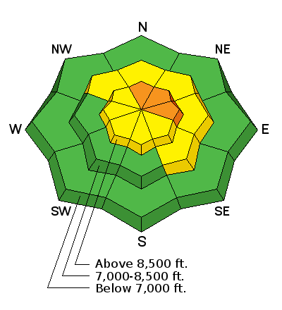
| type | aspect/elevation | characteristics |
|---|

|
|
LIKELIHOOD
 LIKELY
UNLIKELY
SIZE
 LARGE
SMALL
TREND
 INCREASING DANGER
SAME
DECREASING DANGER
|
|
description
The overnight bump in wind speeds created a few new soft wind drifts along the highest ridges and peaks that will be easy to trigger this morning. But once the winds pick up this afternoon, the low-density snow will swiftly form sensitive drifts. The timing for the southwesterly winds to increase is by 2 or 3 pm at the latest, so be ready for rapidly changing conditions, especially at the upper elevations. Keep an eye out for plumes off the peaks and ridges, drifting where you are, or your tracks filling in. Once the winds pick up where you are, get off steep slopes and avoid the terrain below the blowing snow, as natural avalanches could occur. Head to wind sheltered terrain to finish your day – by going to a different aspect or dropping to a lower elevation. |
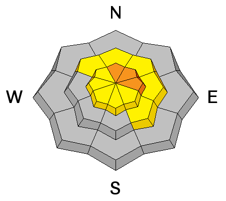
| type | aspect/elevation | characteristics |
|---|

|
|
LIKELIHOOD
 LIKELY
UNLIKELY
SIZE
 LARGE
SMALL
TREND
 INCREASING DANGER
SAME
DECREASING DANGER
|
|
description
Loose Dry Sluffs Dry, loose sluffs can still be triggered today on steep slopes. In continuously steep terrain, a sluff can take you for a ride and debris piles could end up deep enough to bury a person in a terrain trap. Careful slope cuts can keep the sluffs below you instead of above. Loose Wet Sluffs Sun and warmer temperatures may heat the snow, making it easier to trigger sluffs. If the snow becomes warm and sensitive, avoid the steep sunny slopes and head to a different aspect or lower angle terrain. The snow on lower elevation shady slopes may also warm if we get just the right amount of high thin clouds. Cornices “It is difficult to tell where the earth ends and the snow starts” (Brian Smith). So stay well back from the edges of those large cornices and avoid travel beneath them. |
 |
weather The next cold snow producer will arrive tonight. Ahead, high pressure this morning will bring mostly clear skies and light winds, with temperatures warming to near 10 along the ridge lines and into the mid 20s at 8000’. Changes will start early this afternoon – with the southwesterly winds increasing, and averaging 15 to 20 mph, with gusts to 25 at the mid elevations by evening. The highest peaks could average 35 mph, with gusts to 50. Snow will develop late tonight and continue at times through Tuesday, with 8 to 16” possible. A rapid warming trend on Thursday and Friday will end the cold |
general announcements
|