25th Annual Black Diamond Fall Fundraising Party
Thursday, September 13; 6:00-10:00 PM; Black Diamond Parking Lot
25th Annual Black Diamond Fall Fundraising Party
Thursday, September 13; 6:00-10:00 PM; Black Diamond Parking Lot
| Advisory: Ogden Area Mountains | Issued by Evelyn Lees for Saturday - February 25, 2017 - 7:14am |
|---|

|
bottom line This morning, the avalanche danger is MODERATE on steep slopes of all elevations and aspects, where long running sluffs can be triggered. At the mid and upper elevations, there is also a MODERATE danger of triggering an old or newer wind drift. Cornices are huge and will break back further than expected. IF THE WINDS PICK UP WHERE YOU ARE, THE AVALANCHE DANGER WILL INSTANTLY RISE TO CONSIDERABLE on and below steep wind drifted slopes, most likely occuring at the upper elevations. Quickly get out of the wind drifted terrain by heading to a lower elevation or a different aspect.
|
 |
special announcement The CAIC finished their report on the recent snowbike fatality. It's a story worth reading. It was a complex situation, with 3 separate avalanches occurring. A take home is that they had airbags and didn't know they needed beacons, too. A beacon, probe, and shovel are still essential gear, even with an air bag. |
 |
current conditions This winter keeps getting better and better... storm totals of classic Utah powder this week are 3 ½ feet in the Ogden area mountains. Cold temperatures and clouds have preserved the deep low-density powder on all aspects with little settlement. Trail breaking has been epic to match, but a layer of graupel mid storm helped create a more supportable layer. Hand in hand with the winter snow are winter temperatures…most stations are in the single digits to low teens in the Ogden area mountains. West to southwest winds at the highest elevations are flirting with 15 to 20 mph averages (Mt Ogden seems rimed once again), while most other stations are averaging 10 mph or less, though gusting 15 to 25 in the last few hours. |
 |
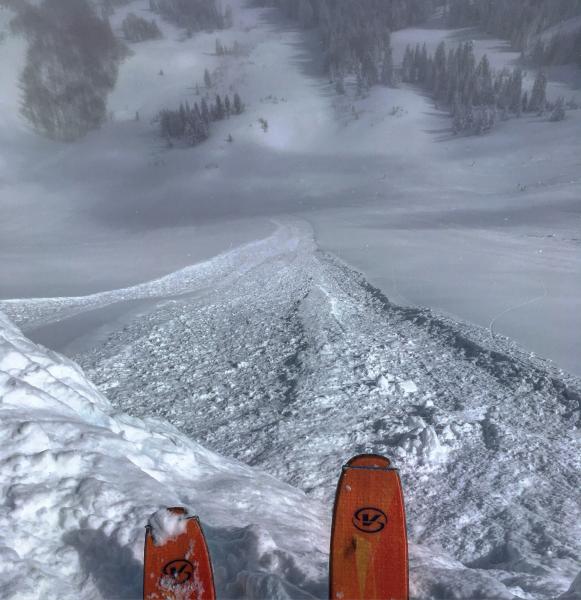
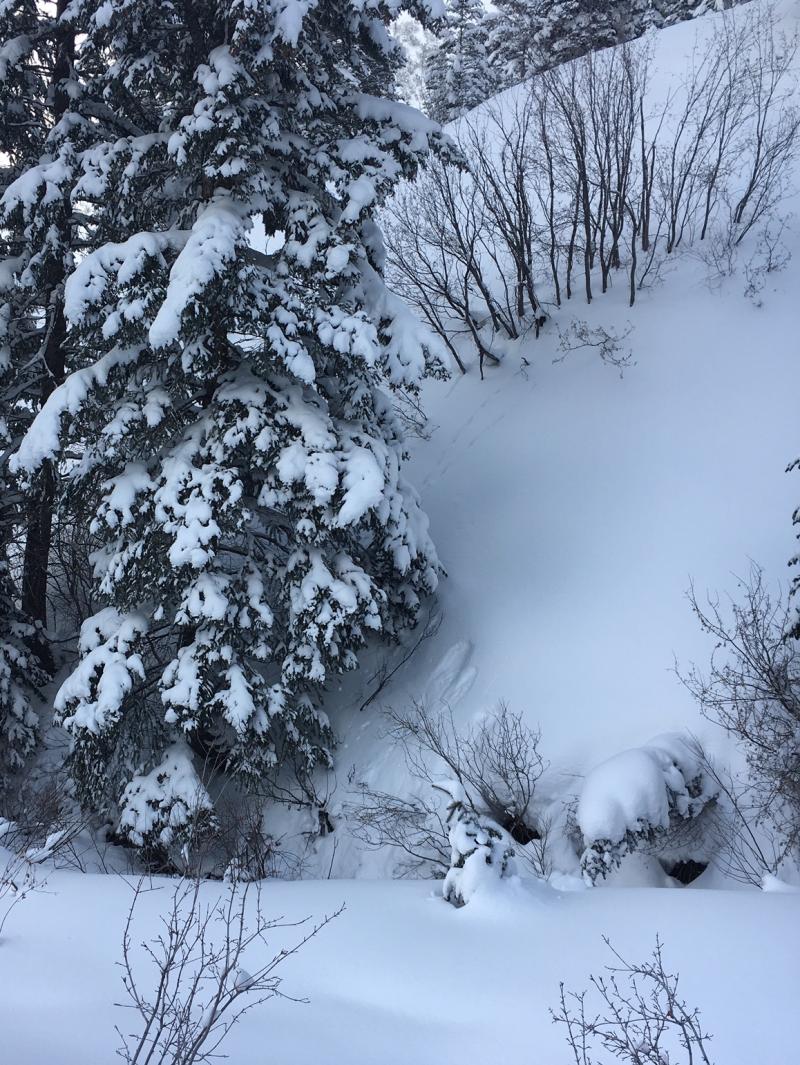
recent activity Yesterday, only reports of some sluffing from the Ogden backcountry. The Ogden resorts reported both soft slabs and sluffs from ski cuts and explosives. Below are photos from the PC/SLC mountains showing the type of avalanches that can be expected today in steeper terrain - a long running sluff and a small wind slab.
|
| type | aspect/elevation | characteristics |
|---|

|
|
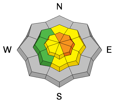
LIKELIHOOD
 LIKELY
UNLIKELY
SIZE
 LARGE
SMALL
TREND
 INCREASING DANGER
SAME
DECREASING DANGER
|
|
description
Wind slabs from the past few days can be triggered – new soft slabs and older wind slabs hidden beneath the new snow. These are mostly at the upper elevations. Today, conditions could change with the blink of an eye if winds increase by 5 to 10 mph. So be ready for rapidly changing conditions, especially at the upper elevations. Keep an eye out for plumes off the peaks and ridges, drifting where you are, or your tracks filling in. If the winds pick up where you are and snow starts to drift, get off steep slopes and avoid the terrain below the blowing snow, as natural avalanches could occur. Head to less wind affected terrain – go to a different aspect or drop to a lower elevation - and continue to have an awesome day of powder. |
| type | aspect/elevation | characteristics |
|---|

|
|
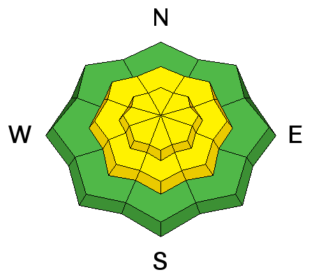
LIKELIHOOD
LIKELY
UNLIKELY
SIZE
LARGE
SMALL
TREND
 INCREASING DANGER
SAME
DECREASING DANGER
|
|
description
People will continue to be able to trigger loose dry sluffs on steep slopes today. Once these sluffs get going, they can go fast and far in continuously steep terrain. Most of the sluffs will be within the storm snow, but on southerly facing slopes and at the lower elevations they could run on the hard ice crusts beneath, giving them that extra distance and bulk. Especially avoid terrain where sluffs can pile up deeply, including creek beds, gullies and tree wells at the lower elevations.
|
| type | aspect/elevation | characteristics |
|---|

|
|
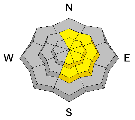
LIKELIHOOD
LIKELY
UNLIKELY
SIZE
LARGE
SMALL
TREND
INCREASING DANGER
SAME
DECREASING DANGER
|
|
description
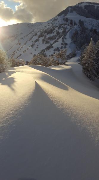
Cornices are enormous, and continue to build day after day. Avoid travel below these mammoths, and stay well back from the edge on top – they break back much further than expected. Some small classic Ogden cornices - they are bigger along the higher ridge lines. Kory Davis photo.
|
 |
weather A weak trough will cross the area today, keeping skies mostly cloudy and temperatures cold. Light snow showers could add up to a trace to 2” of snow by evening. Mid elevations will warm to near 20, along the high ridge lines, temperatures will reach the low to mid teens.10,000’. The south to southwest to westerly winds are forecast to remain light at the mid elevations, but could increase slightly along the higher ridges and peaks, with averages in the 15 to 25 mph range. Stronger winds are expected tonight and tomorrow, with the next storm to arrive Sunday night. |
general announcements
|