25th Annual Black Diamond Fall Fundraising Party
Thursday, September 13; 6:00-10:00 PM; Black Diamond Parking Lot

25th Annual Black Diamond Fall Fundraising Party
Thursday, September 13; 6:00-10:00 PM; Black Diamond Parking Lot
| Advisory: Ogden Area Mountains | Issued by Paige Pagnucco for Friday - February 24, 2017 - 5:57am |
|---|
 |
current conditions Temps are winter-like with 14 F at Ben Lomond (8000') and 9 F at Monte Cristo (8960'). Winds are westerly, blowing 5-10 mph with gusts up to 30 mph in exposed locations. The Ogden area mountains picked up another 17"- 22" in the past 24 hours which is mostly right side up. Storm totals are around 2-3'. The southern end of the forecast zone received quite a bit more snow with 2.2" snow water equivalent just in the past 24 hrs recorded at Parrish Creek (7740'). Snow conditions are back to what they should be in Utah - deep and light. |
 |
recent activity Yesterday's activity was limited to the new snow. Riders were able to easily identify and intentionally trigger small (D1-1.5) soft slabs and sluffs up to 45cm deep with some running on the now more deeply buried 2/20 crust. One event of note was a natural avalanche in Little Cottonwood Canyon that hit an employee parking lot late yesterday afternoon and buried 3-4 cars. Luckily no one was injured. |
| type | aspect/elevation | characteristics |
|---|


|


|

LIKELIHOOD
 LIKELY
UNLIKELY
SIZE
 LARGE
SMALL
TREND
 INCREASING DANGER
SAME
DECREASING DANGER
|
|
description
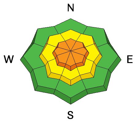
With forecast continued snowfall, the theme from yesterday remains true today as well ... Sensitive, long running, loose snow sluffs and soft slabs will run both naturally and with provocation on steep slopes of all aspects. If snowfall rates intensify, you'll likely see more natural activity occurring on slopes steeper than 35 degrees. Reports of significant graupel from yesterday may make these pack more of a punch if they release where the graupel has pooled. A quick hand pit can reveal the presence of this ball bearing-like weak layer. Though these slabs or sluffs might seem small, they still have the potential to catch, carry and bury a person. Avoid runout zones under steep slopes where human-triggered or natural avalanches might come down from above. Pay particular attention if you are heading out near Farmington or Bountiful as that area received much more snow than other areas. Loose snow and soft slab activity will be bigger and more dangerous. . |
| type | aspect/elevation | characteristics |
|---|


|


|

LIKELIHOOD
 LIKELY
UNLIKELY
SIZE
 LARGE
SMALL
TREND
 INCREASING DANGER
SAME
DECREASING DANGER
|
|
description
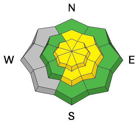
The winds have really calmed down in the past 24 hours. Wind slabs created a day or two ago are now buried under a decent amount of snow and will be harder to detect. If you are traveling in exposed terrain in the upper or mid elevation bands, pay particular attention to changes underfoot and avoid slopes that feel hollow. Any collapsing is an indication of a buried weakness so moving to lower angle slopes would be wise. With lighter density snow falling since last night, there is more snow available for transport in higher elevation exposed terrain. Though winds are forecast to remain relatively mild to moderate throughout the day, wind transport can be localized and any new fresh wind drifts will be sensitive. Avoid steep slopes with fresh wind drifts. Overall, new wind slab formation should remain minimal and really only be an issue in exposed high elevation terrain. |
| type | aspect/elevation | characteristics |
|---|


|


|

LIKELIHOOD
 LIKELY
UNLIKELY
SIZE
 LARGE
SMALL
TREND
 INCREASING DANGER
SAME
DECREASING DANGER
|
|
description
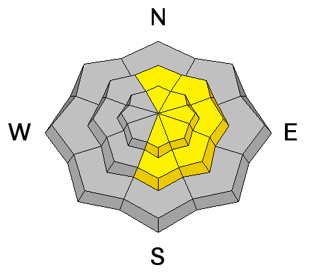
Cornices will continue to be a concern for those traveling along or underneath ridgelines today. It would be a mistake to encroach onto the larger, more concealed cornices to drop a new soft cornice. As shown, these significant triggers may be enough to pull out storm snow down to the February 10th rain crust, resulting in a more dangerous avalanche. |
 |
weather Another classic Utah powder day is on tap - snow is expected to continue before winding down this afternoon. Winds will be westerly, blowing 10-15 mph. It will be chilly with temperatures topping out only in the teens. Another small disturbance with little accumulation is forecast for Saturday eve but another significant storm is likely on Monday-Tuesday. Welcome back Winter, it's good to see you. |
| general announcements Remember your information can save lives. If you see anything we should know about, please help us out by submitting snow and avalanche conditions. You can also call us at 801-524-5304, email by clicking HERE, or include #utavy in your tweet or Instagram. To get help in an emergency (to request a rescue) in the Wasatch, call 911. Be prepared to give your GPS coordinates or the run name. Dispatchers have a copy of the Wasatch Backcountry Ski map. Backcountry Emergencies. It outlines your step-by-step method in the event of a winter backcountry incident. If you trigger an avalanche in the backcountry, but no one is hurt and you do not need assistance, please notify the nearest ski area dispatch to avoid a needless response by rescue teams. Thanks.
EMAIL ADVISORY If you would like to get the daily advisory by email you will need to subscribe here. DAWN PATROL Hotline updated daily by 5-530am - 888-999-4019 option 8. TWITTER Updates for your mobile phone - DETAILS UDOT canyon closures: LINK TO UDOT, or on Twitter, follow @UDOTavy, @CanyonAlerts or @AltaCentral Utah Avalanche Center mobile app - Get your advisory on your iPhone along with great navigation and rescue tools. Powderbird Helicopter Skiing - Blog/itinerary for the day Lost or Found something in the backcountry? - http://nolofo.com/ To those skinning uphill at resorts: it is critical to know the resort policy on uphill travel. You can see the uphill travel policy for each resort here. Benefit the Utah Avalanche Center when you shop from Backcountry.com or REI: Click this link for Backcountry.com or this link to REI, shop, and they will donate a percent of your purchase price to the UAC. Both offer free shipping (with some conditions) so this costs you nothing! Benefit the Utah Avalanche Center when you buy or sell on ebay - set the Utah Avalanche Center as a favorite non-profit in your ebay account here and click on ebay gives when you buy or sell. You can choose to have your seller fees donated to the UAC, which doesn't cost you a penny. This information does not apply to developed ski areas or highways where avalanche control is normally done. This advisory is from the U.S.D.A. Forest Service, which is solely responsible for its content. This advisory describes general avalanche conditions and local variations always |