25th Annual Black Diamond Fall Fundraising Party
Thursday, September 13; 6:00-10:00 PM; Black Diamond Parking Lot
25th Annual Black Diamond Fall Fundraising Party
Thursday, September 13; 6:00-10:00 PM; Black Diamond Parking Lot
| Advisory: Ogden Area Mountains | Issued by Evelyn Lees for Tuesday - February 21, 2017 - 7:11am |
|---|

|
bottom line The avalanche danger is CONSIDERABLE on steep, wind drifted upper and mid elevation slopes. Natural avalanches could occur and hard wind drifts triggered by a person are likely. The wind drifts will be most widespread on mid and upper elevation northwest through north through easterly facing slopes. Cornices are growing and can break back further than expected. At the mid and low elevations, the avalanche danger is MODERATE for triggering wind drifts or wet loose sluffs.
|
 |
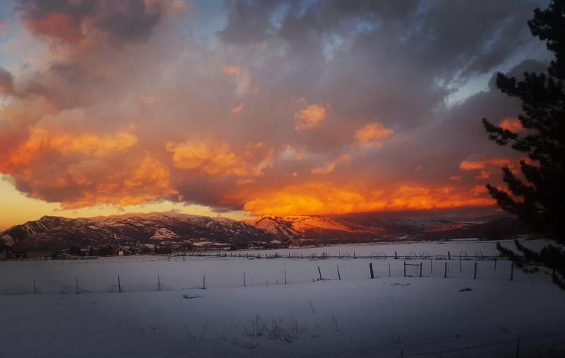
current conditions Just one more warm and windy day before tonight’s cold front brings a nice shot of right-side up snow. Under mostly cloudy skies, overnight temperatures mostly remained in the 30s, with mid 40s at the lowest elevations. The southerly winds are blasting in the Ogden area mountains, with averages at the mid elevations of 40 mph, gusting to 70 mph, and averaging to 50 mph, with gusts to 70 along the higher ridge lines. Ogden sunrise, Kory Davis
|
 |
recent activity Once again, with the strong winds, reports from the Ogden area mountains of 3 large natural avalanches triggered by cornice fall on upper elevation slopes on the windy high ridge lines. These were D2 (or slightly larger - way big enough to kill a person) with crowns 2 to 4 feet deep. Off the ridges, wind slabs were released by explosives and ski cuts, mostly on NE - E facing terrain. Transport occured at mid elevations, too. Wet loose sluffs large enough to catch a person were also reported. Ogden avalanche from over the weekend photo: Joe Keeler
|
| type | aspect/elevation | characteristics |
|---|

|
|
LIKELIHOOD
 LIKELY
UNLIKELY
SIZE
 LARGE
SMALL
TREND
 INCREASING DANGER
SAME
DECREASING DANGER
|
|
description
Strong winds continued through the night, so expect to find hard wind drifts, both along ridge lines and down into open bowls and mid elevation terrain. These will be stubborn hard slabs, which tend to fracture above you. They are especially tricky because the stiffness and thickness of the slab can vary greatly over short distances. You may not be able to trigger a slab in a thick spot, but as you get to the edge of the slab where it thins, you may be able to trigger the whole hard slab. Cornices are enormous this year. They continue to build day after day, and the warm weather makes them more likely to spontaneously break. Avoid travel both below and above, and stay well back from the edge – they break back much further than expected. |
| type | aspect/elevation | characteristics |
|---|

|
|
LIKELIHOOD
 LIKELY
UNLIKELY
SIZE
 LARGE
SMALL
TREND
 INCREASING DANGER
SAME
DECREASING DANGER
|
|
description
One more day before there’s cold air to the rescue. With overnight temperatures at or above freezing at many mid and lower elevations, once again people can trigger shallow wet loose sluffs on steep slopes of all aspects. Once moving, they may pick up more snow than you would expect as they slide down slope on the old hard crusts. Avoid terrain traps such as gullies and creek and road banks and steep rollovers on your exits. Glide avalanches are unpredictable, but prolonged warm weather can be a contributing factor. Avoid travel below opening cracks, most common where there are smooth rock slabs beneath the snow. No crack have been reported yet from the Ogden area mountains, but this is the weather that could start the snow sliding on smooth rock slabs. |
 |
weather Warm and windy today ahead of a cold front, forecast to reach the mountains north of I-80 late this afternoon, and the Salt Lake and Provo area mountains between 5 and 8 pm tonight. Strong winds will persist throughout the event. SNOW/RAIN: A few rain and snow showers today, with moderate to heavy snow starting late afternoon or early tonight, as the snow line drops to the valley floor. 5 to 9” of snow overnight, and another 2 to 4” possible tomorrow for areas favored by northwest flow. TEMPERATURES: Today: 8000’ highs near 50, ridge line highs near 32. Tonight: temperatures dropping into the low twenties and teens. WIND: The south to southwesterly winds will remain strong all day and during frontal passage. Mid elevation stations will average 25 mph, with gusts to 40 mph. The high peaks could average to 50 mph at times, with gusts to 80 mph. Winds will shift to the west and decrease after midnight |
| general announcements GENERAL ANNOUNCEMENTS Remember your information can save lives. If you see anything we should know about, please help us out by submitting snow and avalanche conditions. You can also call us at 801-524-5304, email by clicking HERE, or include #utavy in your tweet or Instagram. To get help in an emergency (to request a rescue) in the Wasatch, call 911. Be prepared to give your GPS coordinates or the run name. Dispatchers have a copy of the Wasatch Backcountry Ski map. Backcountry Emergencies. It outlines your step-by-step method in the event of a winter backcountry incident. If you trigger an avalanche in the backcountry, but no one is hurt and you do not need assistance, please notify the nearest ski area dispatch to avoid a needless response by rescue teams. Thanks.
EMAIL ADVISORY If you would like to get the daily advisory by email you will need to subscribe here. DAWN PATROL Hotline updated daily by 5-530am - 888-999-4019 option 8. TWITTER Updates for your mobile phone - DETAILS UDOT canyon closures: LINK TO UDOT, or on Twitter, follow @UDOTavy, @CanyonAlerts or @AltaCentral Utah Avalanche Center mobile app - Get your advisory on your iPhone along with great navigation and rescue tools. Powderbird Helicopter Skiing - Blog/itinerary for the day Lost or Found something in the backcountry? - http://nolofo.com/ To those skinning uphill at resorts: it is critical to know the resort policy on uphill travel. You can see the uphill travel policy for each resort here. Benefit the Utah Avalanche Center when you shop from Backcountry.com or REI: Click this link for Backcountry.com or this link to REI, shop, and they will donate a percent of your purchase price to the UAC. Both offer free shipping (with some conditions) so this costs you nothing! Benefit the Utah Avalanche Center when you buy or sell on ebay - set the Utah Avalanche Center as a favorite non-profit in your ebay account here and click on ebay gives when you buy or sell. You can choose to have your seller fees donated to the UAC, which doesn't cost you a penny. This information does not apply to developed ski areas or highways where avalanche control is normally done. This advisory is from the U.S.D.A. Forest Service, which is solely responsible for its content. This advisory describes general avalanche conditions and local variations always |