25th Annual Black Diamond Fall Fundraising Party
Thursday, September 13; 6:00-10:00 PM; Black Diamond Parking Lot
25th Annual Black Diamond Fall Fundraising Party
Thursday, September 13; 6:00-10:00 PM; Black Diamond Parking Lot
| Advisory: Ogden Area Mountains | Issued by Evelyn Lees for Monday - February 20, 2017 - 7:15am |
|---|

|
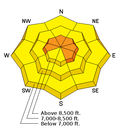
bottom line The avalanche danger is rapidly rising to CONSIDERABLE as the wind blows the snow into sensitive drifts. These wind drifts will be easily triggered by a person, and most widespread on upper elevation northwest through north through easterly facing slopes. Cornices are growing and can break back further than expected. Out of the wind-affected terrain, the avalanche danger is MODERATE for triggering smaller new snow slides and MODERATE at the mid and low elevations for wet loose sluffs.
|
 |
current conditions After 2 days of unimpressive light snow, the last wave burst onto the scene, with several hours of heavy snowfall at the upper elevation. Storm totals since Friday are 15 to 17” of snow in the Ogden area mountains, 9 to 14” along the Park City ridge line, 14 to 23” in the upper Cottonwoods, and up to 6” at the mid elevations in the Provo area mountains. The rain/snowline was often near 7 - 8000’, and there was significant rain at the lower elevations. This morning, under partly cloudy skies, temperatures are in the mid 20s to low 30s. The south to southwesterly winds are quickly ramping up, already 25 to 35 mph, with gusts to 40, and the windiest ridgelines are averaging 40, with gusts to 65. Some of the Ogden mountain anemometers may be rimed or just not working. Head to the upper elevations for excellent powder conditions. |
 |
recent activity Ogden area mountains: There was a report from Cutler ridge of easily triggered new snow avalanches, and low elevation push-a-lanches. There was a natural avalanche cycle in upper backcountry cirques from Strawberry to Mt. Ogden. Additional reports from the resorts include class 1 and 2 avalanches with control work (class 2 slides are large enough to carry and bury a person) and reports that it was easy to trigger wet loose sluffs in the lower elevation rain saturated snow. The slick rain crust in the Ogden area mountains from February 9th and 10th is becoming a repeater bed surface on almost all aspects and elevations. |
| type | aspect/elevation | characteristics |
|---|

|
|
LIKELIHOOD
 LIKELY
UNLIKELY
SIZE
 LARGE
SMALL
TREND
 INCREASING DANGER
SAME
DECREASING DANGER
|
|
description
Just as we get a re-set on winter, here come the winds to ruin it. Already strong enough this morning to drift snow along the highest ridgelines, they are forecast to increase all day long. Keep a sharp eye on the wind speeds where you are today. The new wind drifts will be rounded, scalloped, dense and cracky. They will be most widespread along the upper elevation ridge lines, on slopes facing the north ½ of the compass. As the winds continue, the drifts will become more widespread, deeper, and also down onto mid elevations slopes. Cornices are still an issue. A person can trigger both big old cornices and fresh new cornices today. Cornices continue to break back further than you would expect, and could trigger a new snow slide on the slope below |
| type | aspect/elevation | characteristics |
|---|

|

|
LIKELIHOOD
 LIKELY
UNLIKELY
SIZE
 LARGE
SMALL
TREND
 INCREASING DANGER
SAME
DECREASING DANGER
|
|
description
Out of the wind-affected terrain, the new storm snow should be rapidly stabilizing on most slopes. The exception is on northwest, north and northeasterly facing slopes, where the layer of faceted snow beneath the storm remains weak. Slides averaging foot deep and 100’ or wider can be triggered, definitely large enough to take a person for a ride. On other aspects, the old hard frozen crusts are acting as good bed surfaces, and a triggered slide can be longer running than expected. |
| type | aspect/elevation | characteristics |
|---|

|

|
LIKELIHOOD
LIKELY
UNLIKELY
SIZE
LARGE
SMALL
TREND
INCREASING DANGER
SAME
DECREASING DANGER
|
|
description
We just can’t lose the Wet Loose avalanche problem this winter - you'd think we were in the northwest or something. Overnight, temperatures made only a brief foray below freezing at low to mid elevations and are already climbing this morning. Rapid warming today will produce wet sloppy snow at the mid and lower elevations, and wet loose sluffs will be easily triggered on steep slopes. Avoid terrain traps such as gullies and creek and road banks and avoid steep rollovers on your exits. The sun should be minimal today, but if the clouds are thin where you are, the upper elevation sunny slopes will also become damp and sloppy. |
 |
weather A mild southwest flow will be over the Wasatch today through Tuesday with occasional snow showers. SNOW: 1 to 2” possible today, and again tonight, with the rain/snow line around 7,500’. TEMPERATURES: warming today to near 40 at 8000’ and to near 30 along the high ridge lines. Tonight, a poor overnight refreeze under cloudy skies, and even warmer tomorrow. WIND: southwesterly winds will increase throughout the day, with 35 mph averages, with gusts in the 40s. Across the highest peaks, averages will reach 45 mph, with gusts in the 60s. It will be even windier and warmer on Tuesday, but a welcome cold front will arrive Tuesday night, bringing periods of cold, dry snow through Thursday |
| general announcements Remember your information can save lives. If you see anything we should know about, please help us out by submitting snow and avalanche conditions. You can also call us at 801-524-5304, email by clicking HERE, or include #utavy in your tweet or Instagram. To get help in an emergency (to request a rescue) in the Wasatch, call 911. Be prepared to give your GPS coordinates or the run name. Dispatchers have a copy of the Wasatch Backcountry Ski map. Backcountry Emergencies. It outlines your step-by-step method in the event of a winter backcountry incident. If you trigger an avalanche in the backcountry, but no one is hurt and you do not need assistance, please notify the nearest ski area dispatch to avoid a needless response by rescue teams. Thanks.
EMAIL ADVISORY If you would like to get the daily advisory by email you will need to subscribe here. DAWN PATROL Hotline updated daily by 5-530am - 888-999-4019 option 8. TWITTER Updates for your mobile phone - DETAILS UDOT canyon closures: LINK TO UDOT, or on Twitter, follow @UDOTavy, @CanyonAlerts or @AltaCentral Utah Avalanche Center mobile app - Get your advisory on your iPhone along with great navigation and rescue tools. Powderbird Helicopter Skiing - Blog/itinerary for the day Lost or Found something in the backcountry? - http://nolofo.com/ To those skinning uphill at resorts: it is critical to know the resort policy on uphill travel. You can see the uphill travel policy for each resort here. Benefit the Utah Avalanche Center when you shop from Backcountry.com or REI: Click this link for Backcountry.com or this link to REI, shop, and they will donate a percent of your purchase price to the UAC. Both offer free shipping (with some conditions) so this costs you nothing! Benefit the Utah Avalanche Center when you buy or sell on ebay - set the Utah Avalanche Center as a favorite non-profit in your ebay account here and click on ebay gives when you buy or sell. You can choose to have your seller fees donated to the UAC, which doesn't cost you a penny. This information does not apply to developed ski areas or highways where avalanche control is normally done. This advisory is from the U.S.D.A. Forest Service, which is solely responsible for its content. This advisory describes general avalanche conditions and local variations always exist. |


