Avalanche Advisory
Advisory: Ogden Area Mountains Issued by Paige Pagnucco for Friday - February 17, 2017 - 5:47am
bottom line

There is a mostly LOW avalanche danger in the Ogden area mountains. Wet and dry sluffs in the surface snow are possible in steep terrain. Fresh deposits of wind drifted snow may be shallow and isolated, but could be sensitive to human provocation.

Remember that your choice of terrain will either amplify or minimize the overall risk of incident.


special announcement

Interested in learning how to travel safely in avalanche terrain? Join us next week for this workshop which begins with a three hour evening class on Thursday followed by a on-the-snow field day on Saturday. For more info or to register click here.

Read Drew's companion piece to #NothingBadHappened called Hindsight 20/40.

current conditions

Temps are just below freezing at 8000' in the Ogden zone this morning with winds blowing out of the southwest at 10-15 mph and gusts around 20 mph. Yesterday, the southwest winds were very strong, in the 30-40 mph range with gusts up to 62 mph, moving what little there was in the way of loose snow in exposed areas.

Turning conditions range from "wow, this isn't too bad" to "I hiked 3 hours for this?!." Reports of decent spring corn conditions on south facing slopes exist but are limited as many folks have chosen to pursue other activities while waiting for a snow refresher. Surface conditions across the zone range from corn to crusts of varying thicknesses to tiny pockets of faceted dry soft snow. Everything is sitting on a hard, slick rain crust which makes sticking to lower angle terrain the more fun, less noisy, and generally better riding option.

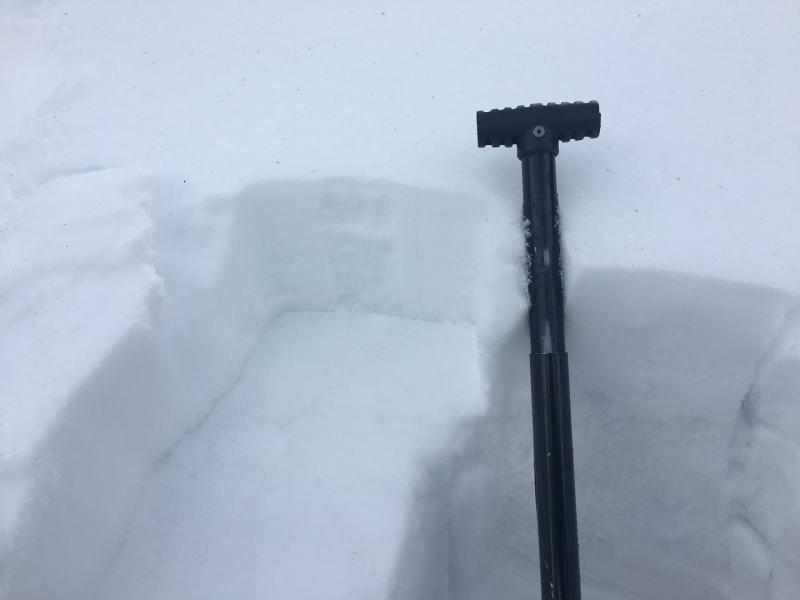
recent activity

We were able to initiate "pushalanches" yesterday on a steep, mid-elevation N facing slope. What was most interesting about the snow was the ease with which the top 6" slid on the hard rain crust from last week due to the dry, faceted snow between the hard rain crust and the top 2-3" of the pack, which were moist. The small slides had no trouble picking up speed under their own weight. We'll keep an eye on this weak, faceted snow as we start to accumulate any new load.


Avalanche Problem 1
type aspect/elevation characteristics
LIKELIHOOD
LIKELY
UNLIKELY
SIZE
LARGE
SMALL
TREND
INCREASING DANGER
SAME
DECREASING DANGER
over the next 24 hours
description

Continue to use normal caution as you move around the backcountry today and remember that risk is inherent in mountain travel. Avalanche concerns for the backcountry include the following:

  • Shallow fresh wind deposits will be generally relegated to upper elevation ridge lines. While probably very shallow, any new drifts may be sensitive to human provocation today, especially if they are sitting on top of weak, faceted snow. They'll be more pronounced on north through east facing slopes above 8500'.
  • Continued dry sluffing in the weakening surface snow in steep northerly terrain at upper elevations. Ski cuts are effective mitigation tools for these though be mindful of the slick rain crust underneath.
  • Continued wet sluffing with daytime warming. Even steep north facing slopes at mid-elevations were showing signs of this type of instability yesterday. No matter what the aspect or elevation, if it's getting sloppy, it's time to move off of and out from underneath steep slopes.
  • Cornices loom large over many ridgelines - continue to give them a very wide berth. Here's a cool cornice observation from the nearby Logan zone.
weather

The pattern is changing! Expect skies to become mostly cloudy today ahead of a small low pressure moving into the area. Temps are forecast to reach the mid 30's around 8000' with 10-20 mph winds expected to become a bit easterly this morning before swinging back to the south. The Ogden area mountains could see 1-2" of snow by tonight. A stronger impulse arrives tonight with stronger winds and maybe another 3-5" of snow by Saturday morning.

general announcements

Remember your information can save lives. If you see anything we should know about, please help us out by submitting snow and avalanche conditions. You can also call us at 801-524-5304, email by clicking HERE, or include #utavy in your tweet or Instagram.

To get help in an emergency (to request a rescue) in the Wasatch, call 911. Be prepared to give your GPS coordinates or the run name. Dispatchers have a copy of the Wasatch Backcountry Ski map.

Backcountry Emergencies. It outlines your step-by-step method in the event of a winter backcountry incident.

If you trigger an avalanche in the backcountry, but no one is hurt and you do not need assistance, please notify the nearest ski area dispatch to avoid a needless response by rescue teams. Thanks.

EMAIL ADVISORY If you would like to get the daily advisory by email you will need to subscribe here.

DAWN PATROL Hotline updated daily by 5-530am - 888-999-4019 option 8.

TWITTER Updates for your mobile phone - DETAILS

UDOT canyon closures: LINK TO UDOT, or on Twitter, follow @UDOTavy, @CanyonAlerts or @AltaCentral

Utah Avalanche Center mobile app - Get your advisory on your iPhone along with great navigation and rescue tools.

Powderbird Helicopter Skiing - Blog/itinerary for the day

Lost or Found something in the backcountry? - http://nolofo.com/

Ski Utah mobile snow updates

To those skinning uphill at resorts: it is critical to know the resort policy on uphill travel. You can see the uphill travel policy for each resort here.

Benefit the Utah Avalanche Center when you shop from Backcountry.com or REI: Click this link for Backcountry.com or this link to REI, shop, and they will donate a percent of your purchase price to the UAC. Both offer free shipping (with some conditions) so this costs you nothing!

Benefit the Utah Avalanche Center when you buy or sell on ebay - set the Utah Avalanche Center as a favorite non-profit in your ebay account here and click on ebay gives when you buy or sell. You can choose to have your seller fees donated to the UAC, which doesn't cost you a penny.

This information does not apply to developed ski areas or highways where avalanche control is normally done. This advisory is from the U.S.D.A. Forest Service, which is solely responsible for its content. This advisory describes general avalanche conditions and local variations always exist.