25th Annual Black Diamond Fall Fundraising Party
Thursday, September 13; 6:00-10:00 PM; Black Diamond Parking Lot
25th Annual Black Diamond Fall Fundraising Party
Thursday, September 13; 6:00-10:00 PM; Black Diamond Parking Lot
| Advisory: Ogden Area Mountains | Issued by Paige Pagnucco for Friday - February 10, 2017 - 5:14am |
|---|


|
bottom line The avalanche danger is CONSIDERABLE for wet loose and possibly wet slab avalanches on all aspects at the low to mid elevations. Even damp rollerballs and wet sluffs may be expected with provocation on all but the highest northerly elevations. Un-Utah-like snowpack and weather warrants conservative decision making and cautious route finding in the backcountry today. Cornice-fall, roof and glide avalanches are all inherently dangerous...and all are quite possible today. Ice climbing is not recommended.
|
 |
current conditions Still maritime conditions today but intercontinental is fighting its way back with the approaching storm. 5 am temps ranged from 41 F on Ben Lomond to 33 F on James Peak. South southwest winds were strong overnight with gusts around 60 mph. Currently, SSW winds are blowing 20-30 mph. Suprisingly there were not many observations from the Ogden area backcountry yesterday. Those that did venture out noted wet snow conditions with a range of supportability. Turning conditions were slow and sticky up to 9000'. It can only get better with the approaching cooler temperatures. Snowmobilers report wet yet decent riding conditions as long as they avoided getting stuck. Tomorrow's conditions look more promising with cooler temps and fresh snow. |
 |
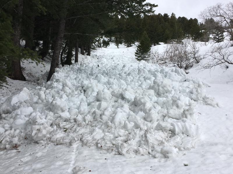
recent activity Wet avalanche activity was prevalent overnight Wednesday - Thursday. We found a nice sized new wet loose avalanche yesterday in Lime Kiln on the east side of the Divide. The second picture is of a wet loose avalanche on the south side of the Divide. (pc: K. Davis)
|
| type | aspect/elevation | characteristics |
|---|

|
|
LIKELIHOOD
 LIKELY
UNLIKELY
SIZE
 LARGE
SMALL
TREND
 INCREASING DANGER
SAME
DECREASING DANGER
|
|
description
We are expecting a slow return to winter by tonight but for now the current snowpack is completely saturated and sloppy and temps are warm. It''ll take at least a few nights of freezing temps to solidify the snow deep enough to minimize wet avalanche activity. With forecast rain at mid and low elevations and a poor overnight refreeze (again), wet loose and wet slab activity on steep slopes on all aspects is likely today. Rollerballs are the biggest clue to instability as is sinking deeply into the glop. Kory and I were able to create small wet sluffs without much effort on steep test slopes yesterday. These small sluffs can entrain more heavy, wet snow as they move downslope so it'll be wise to avoid being on or underneath slopes steeper than 30-35 degrees today. Avoid terrain traps such as gullies and creek beds where snow can pile up deeply very quickly. ROOF AVALANCHES continue to be a concern. Avoid being in the "runout zones". |
| type | aspect/elevation | characteristics |
|---|

|
|
LIKELIHOOD
LIKELY
UNLIKELY
SIZE
 LARGE
SMALL
TREND
INCREASING DANGER
SAME
DECREASING DANGER
|
|
description
Cornices have been drooping and draining water over the past few days. They are unstable and should be avoided. Chunks of falling cornice can cause a much bigger and more dangerous wet avalanche below. There is also a small chance of wind slabs developing today in the highest elevation terrain on leeward slopes. Sustained southwest winds, cooling temps and forecast snowfall are key ingredients for wind slab formation. The limiting factor for these is the existing wet snow won't offer much in the way of a sliding surface. Still a good thing to keep in mind though if you make into higher elevation terrain. |
 |
weather The National Weather Service has issued a Winter Weather Advisory for the mountains of northern Utah. More warm, wet, and windy weather is forecast for today though at least the temperatures are supposed to start slowly cooling off. Moisture type will depend on your elevation as the rain /snow line will hover around 8000' before dropping to 6000' by this evening. The mountains could see 8-12" by tomorrow morning with higher amounts in areas favored by southwest flow. Snow will continue through tonight then gradually taper off tomorrow morning as high pressure builds back in to the area. |
general announcements
|