25th Annual Black Diamond Fall Fundraising Party
Thursday, September 13; 6:00-10:00 PM; Black Diamond Parking Lot
25th Annual Black Diamond Fall Fundraising Party
Thursday, September 13; 6:00-10:00 PM; Black Diamond Parking Lot
| Advisory: Ogden Area Mountains | Issued by Mark Staples for Monday - February 6, 2017 - 7:00am |
|---|


|
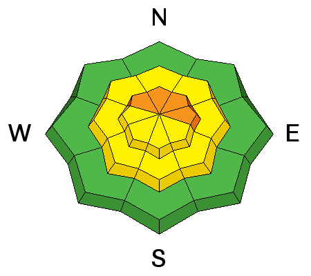
bottom line The avalanche danger today is CONSIDERABLE at upper elevations where fresh wind slabs can easily be triggered. The danger is MODERATE at mid to lower elevations. Dig into the snow to look for weak layers that can cause persistent slab avalanches, and watch for loose, wet snow avalanches at the lowest elevations.
|
 |
special announcement If you have time to kill, check out our recorded live Instagram digital fireside chat from Wednesday night. These fireside chats are informal discussions on the state of the snowpack and involve questions and comments from viewers. We hope to have more in the coming weeks. |
 |
current conditions Strong southerly winds arrived late last night, and a trace to one inch of snow fell. This morning they are averaging 30-40 mph gusting 60-70 mph from the S and SW. Temperatures are near freezing at 8000 feet. |
 |
recent activity Two days ago, snow safety teams at ski areas triggered some stubborn wind drifts up to a foot deep. Regular observers on Ben Lomond Peak saw plenty of wind loading yesterday. |
| type | aspect/elevation | characteristics |
|---|

|
|
LIKELIHOOD
 LIKELY
UNLIKELY
SIZE
 LARGE
SMALL
TREND
 INCREASING DANGER
SAME
DECREASING DANGER
|
|
description
Strong southerly winds have formed fresh wind slabs this morning which should be easy to trigger. With a little snow expected today and continued strong winds, fresh wind slabs should remain sensitive and become larger throughout the day. Many ridgelines have massive cornices which will continue growing this week with more snow and more wind. These are unpredictable and have killed many experienced mountaineers. They often break further back than many expect. Avoid traveling near these monsters. |
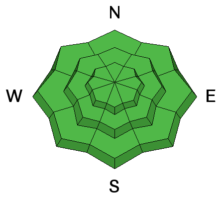
| type | aspect/elevation | characteristics |
|---|

|
|
LIKELIHOOD
 LIKELY
UNLIKELY
SIZE
LARGE
SMALL
TREND
 INCREASING DANGER
SAME
DECREASING DANGER
|
|
description
With so much snowfall over the last several weeks, buried persistent weak layers seem to have healed. They still exists and are worth looking for especially as we get more snow over the next several days. Dig 4 feet into the snow, look for a stripe in a clean pit wall, and do a quick extended column test. With some practice, this process should only take 5 minutes. |
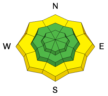
| type | aspect/elevation | characteristics |
|---|

|
|
LIKELIHOOD
 LIKELY
UNLIKELY
SIZE
 LARGE
SMALL
TREND
INCREASING DANGER
SAME
DECREASING DANGER
|
|
description
Some loose wet avalanches are possible at the lowest elevations where overnight temperatures were near 40 degrees F. Watch for these slides if any rain falls. Watch Toby's video about loose wet slides in Logan Canyon. |
 |
weather Today freezing temperatures should remain near 8000 feet though the rain snow line should be closer to 6000 feet. Strong winds will continue from the SW blowing 20-30 mph. At the highest elevations, much stronger winds will blow with gusts over 70 mph. Snowfall today should only bring a few inches. Heavier snowfall will occur tonight with and additional 7-10 inches possible. The rain/snow line should rise to 7500 feet this evening and Tuesday and then drop tomorrow afternoon. |
general announcements
|


