25th Annual Black Diamond Fall Fundraising Party
Thursday, September 13; 6:00-10:00 PM; Black Diamond Parking Lot
25th Annual Black Diamond Fall Fundraising Party
Thursday, September 13; 6:00-10:00 PM; Black Diamond Parking Lot
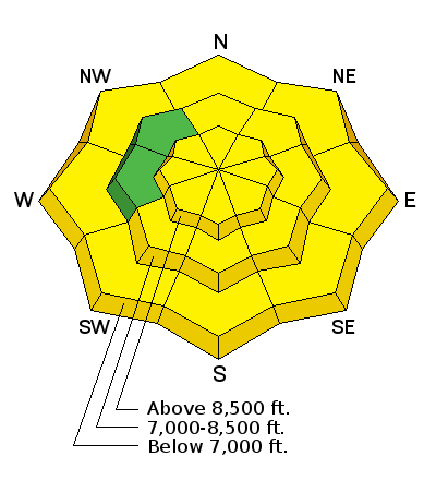
| Advisory: Ogden Area Mountains | Issued by Drew Hardesty for Sunday - February 5, 2017 - 7:05am |
|---|

|
bottom line A MODERATE danger exists for lingering wind drifts at the mid and upper elevations. Wet avalanche activity will also rise to MODERATE on the steep sunlit slopes and low elevations of all aspects with daytime warming. Creaky old cornices along the ridgelines should be avoided with great caution. Remember safe travel protocols save lives: make a plan, ski and ride one at a time, get out of the way at the bottom. Ask yourself: what will happen if I trigger even a small avalanche in this terrain below?
|
 |
special announcement Also - for those that enjoy podcasts - Doug Krause has an excellent new avalanche-related podcast appropriately named Slide. It is a nice combination of practical advice, snow science, as well as human factor issues. Last, and certainly least: if you have time to kill, check out our recorded live Instagram digital fireside chat from Wednesday night. These fireside chats are informal discussions on the state of the snowpack and involve questions and comments from viewers. We hope to have more in the coming weeks. |
 |
current conditions Skies are partly cloudy. Winds remain westerly to southwesterly, blowing 25-30mph, gusting to 40 along the higher ridgelines and peaks above Ogden. Mountain temperatures are in the upper 20s to low 30s. Riding conditions are quite good in the thick, supportable graupel and dense snow from late in the week. Snow totals sit at and above 100'" at Snowbasin and Powder Mountain. Sunny aspects will have a breakable crust this morning. Low elevations are becoming soggy, wet, and in some cases, unsupportable. If you have a minute between the Super Bowl commercials this afternoon, I recommend rummaging through the closet to look for, uh, what they call, "wind-resistant" clothing to have on tap for the next several days. More on that in Mountain Weather. Week in Review by Greg Gagne can be found here. |
 |
recent activity The mountain resort control teams reported touchy to stubborn wind drifts up to a foot deep yesterday. Mike and Derek observed significant wind loading up high on the Cutler Ridge/Ogden skyline, but prudently avoided this terrain. |
| type | aspect/elevation | characteristics |
|---|

|
|
LIKELIHOOD
 LIKELY
UNLIKELY
SIZE
 LARGE
SMALL
TREND
 INCREASING DANGER
SAME
DECREASING DANGER
|
|
description
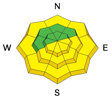
Time, warmth, settlement should conspire to help stabilize many of the last 48 hours of wind drifts. While sensitivity has diminished (but not to zero), the size will be roughly the same. Test slopes, ski cuts, and cornice drops will provide good indication of conditions. Remember that many of these lingering, isolated drifts are not limited to the classic leeward loading zones but rather well off the ridgelines beyond terrain features or cross-loaded into steep couloirs or gullies. The growing white whales of cornices should be avoided with great caution and care. Recall that the old cornices tend not to break at the apex, but well back beyond the ridgelines.
|
| type | aspect/elevation | characteristics |
|---|

|
|
LIKELIHOOD
 LIKELY
UNLIKELY
SIZE
LARGE
SMALL
TREND
 INCREASING DANGER
SAME
DECREASING DANGER
|
|
description
Snow structure and stability seem good here, as well evidenced by M. Henderson's video below. No cracking or collapsing or recent avalanches has been noted on this layering, but this next set of storms will provide a good test. Video here https://www.youtube.com/watch?v=_uzFqoR6kUo#action=share |
| type | aspect/elevation | characteristics |
|---|

|
|
LIKELIHOOD
LIKELY
UNLIKELY
SIZE
LARGE
SMALL
TREND
INCREASING DANGER
SAME
DECREASING DANGER
|
|
description
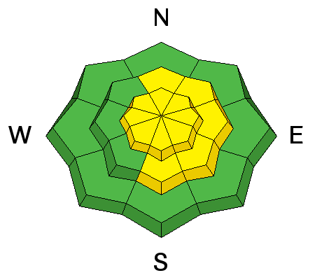
Reports of the lowest elevations indicate a soggy, nearly unsupportable mess at the lower elevations. Continued warming today should keep wet loose avalanches on your radar in the lowest elevations or on your exits to the trailheads. Pay particular attention to steep cut-banks or steep rolls into creekbeds where the wet debris may pile up more deeply. East to south to potentially southwesterly aspects will soften and become damp with direct sun and daytime warming. With enough solar input, human triggered wet loose avalanches will be possible in the steep sunlit terrain today. Cloud cover will probably offset this potential on the westerly aspects by mid-afternoon. |
 |
weather Today will be a bit of a break day ahead of the next series of storms. Did I mention wind? They'll kick in early evening. A wet, warm, and windy series of storms approach from the west that'll bring heavy dense snow to the northern and central mountains of the state. Accompanying winds look to rarely be below 30mph with some hourly averages approaching 50mph with gusts to 70. The rain/snow line may rise toward 7500' by Tuesday. All told, I can see 16-24"+ in areas favored by a westerly flow by Thursday. |
general announcements
|


