25th Annual Black Diamond Fall Fundraising Party
Thursday, September 13; 6:00-10:00 PM; Black Diamond Parking Lot
25th Annual Black Diamond Fall Fundraising Party
Thursday, September 13; 6:00-10:00 PM; Black Diamond Parking Lot
| Advisory: Ogden Area Mountains | Issued by Drew Hardesty for Saturday - February 4, 2017 - 7:15am |
|---|

|
bottom line The avalanche danger is MODERATE on steep, wind drifted, upper and mid elevation slopes. Avoid steep slopes in exposed terrain where moderate winds combined with moderate snowfall have and will continue to develop wind slabs. Watch for wet avalanche activity on steep slopes at lower elevations on all aspects.
|
 |
special announcement For those that enjoy podcasts - Doug Krause has an excellent new avalanche-related podcast appropriately named Slide. It is a nice combination of practical advice, snow science, as well as human factor issues. Last, and certainly least: if you have time to kill, check out our recorded live Instagram digital fireside chat from Wednesday night. These fireside chats are informal discussions on the state of the snowpack and involve questions and comments from viewers. We hope to have more in the coming weeks. |
 |
current conditions The wind. Hoods extended, goggles on, yesterday we bent against the wind as faceless, nameless penitents as if in supplication to some unknown and unknowable weather gods. We were not alone. We shared the ridgelines with krummholz, the stunted, twisted and forever leewardly bent-in-supplication conifers. Krummholz might best be translated from the German as "old man", and it's obvious why. As of 5am, we've received another 3-5" on a southwesterly flow. Rain-snow line was reported as 5800' and the Ben Lomond trail snotel site reports a current temp of 41 degrees and possibly 0.7" of water overnight. Mountain temperatures are in the upper 20s. Winds are now westerly, blowing 20-25mph with gusts to 35. Skyline winds have had hourly averages of 40-50 with gusts to 60. Snow surface conditions: thick powder snow in the protected northerly terrain, lipstick on a pig dust on coarse, corrugated melt-freeze crusts on the sunny aspects, and generally damp "coastal" powder in the lower elevations...and wet, saturated snow at and below the snow/rain line. |
 |
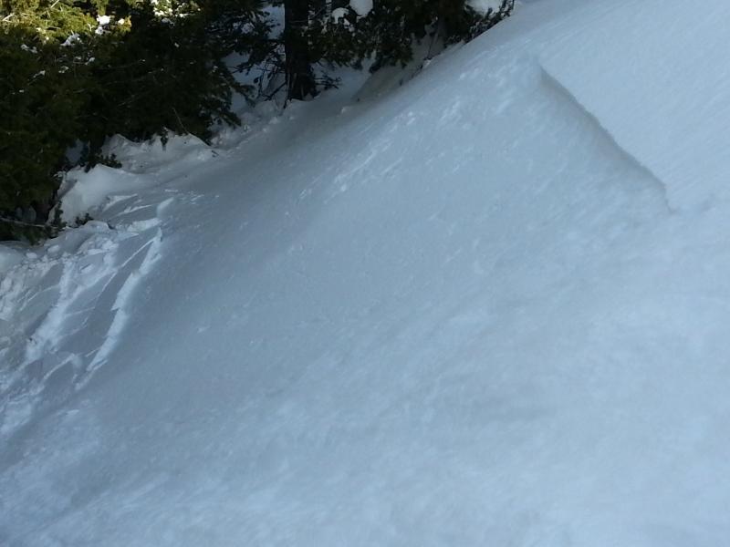
recent activity Yesterday's activity centered around shallow pockets of soft sensitive wind drifts 4-6" deep and up to 35' wide on many aspects at the mid and upper elevations. (pics: Bill Hunt).
|
| type | aspect/elevation | characteristics |
|---|

|

|
LIKELIHOOD
 LIKELY
UNLIKELY
SIZE
 LARGE
SMALL
TREND
 INCREASING DANGER
SAME
DECREASING DANGER
|
|
description
Winds swirled in all directions yesterday, with shallow drifts on east facing aspects, west facing aspects and in many deceleration zones well off the ridgelines. None of these were big enough to bury you, but the additional overnight snow and wind will make these a touch more problematic - particularly in and above committing and unforgiving terrain. Ski cuts and cornice drops should be effective mitigation tools for experienced practitioners; however avoidance of the smooth and rounded drifts while powder hunting in the low angle trees is always a good bet. Remember that cracking (below) and thick, slabby texture are often red to yellow signs of instability. (pic: C.Frantz)
|
| type | aspect/elevation | characteristics |
|---|

|
|
LIKELIHOOD
 LIKELY
UNLIKELY
SIZE
LARGE
SMALL
TREND
INCREASING DANGER
SAME
DECREASING DANGER
|
|
description
It's getting harder and harder to find the elusive buried surface hoar and associated near surface facets that were quite apparent before the last storm. Similar to Brian Smith's observation from Tuesday, we were unable to find buried surface hoar yesterday or really any significant persistent weak layers in the top 5 feet for that matter. Compression and settlement may have mostly snuffed them out but I'm not totally convinced there gone everywhere. At 7500' on a north facing slope we found a total snow height of over 12 feet, a deeper than average pack for the area. At this point, I think we'd need to get another atmospheric river event to reactivate persistent weak layers, which, again, would only be in isolated areas where the surface hoar or near surface facet's are well preserved. |
| type | aspect/elevation | characteristics |
|---|

|
|
LIKELIHOOD
LIKELY
UNLIKELY
SIZE
LARGE
SMALL
TREND
 INCREASING DANGER
SAME
DECREASING DANGER
|
|
description
Watch for loose wet avalanche activity on steep slopes on all aspects at lower elevations. There is also still a chance for roof avalanches today with warm temps - stay out from under any roof that still holds a significant amount of snow. Rollerballs and natural sluffs are key indicators; if you find yourself in soggy, unsupportable snow, avoid steep terrain, especially that which dumps into terrain traps such as creekbeds. |
 |
weather Light snow should continue for the next couple of hours before tapering off. Mountain temperatures will be in the mid-20s with west to southwest winds blowing 20-25mph. The next storm arrives Monday through the early part of the week. Strong southerly winds also accompany this system until Monday night's frontal passage, ushering in additional snow and much cooler temps. |
| general announcements Remember your information can save lives. If you see anything we should know about, please help us out by submitting snow and avalanche conditions. You can also call us at 801-524-5304, email by clicking HERE, or include #utavy in your tweet or Instagram. To get help in an emergency (to request a rescue) in the Wasatch, call 911. Be prepared to give your GPS coordinates or the run name. Dispatchers have a copy of the Wasatch Backcountry Ski map. Backcountry Emergencies. It outlines your step-by-step method in the event of a winter backcountry incident. If you trigger an avalanche in the backcountry, but no one is hurt and you do not need assistance, please notify the nearest ski area dispatch to avoid a needless response by rescue teams. Thanks.
EMAIL ADVISORY If you would like to get the daily advisory by email you will need to subscribe here. DAWN PATROL Hotline updated daily by 5-530am - 888-999-4019 option 8. TWITTER Updates for your mobile phone - DETAILS UDOT canyon closures: LINK TO UDOT, or on Twitter, follow @UDOTavy, @CanyonAlerts or @AltaCentral Utah Avalanche Center mobile app - Get your advisory on your iPhone along with great navigation and rescue tools. Powderbird Helicopter Skiing - Blog/itinerary for the day Lost or Found something in the backcountry? - http://nolofo.com/ To those skinning uphill at resorts: it is critical to know the resort policy on uphill travel. You can see the uphill travel policy for each resort here. Benefit the Utah Avalanche Center when you shop from Backcountry.com or REI: Click this link for Backcountry.com or this link to REI, shop, and they will donate a percent of your purchase price to the UAC. Both offer free shipping (with some conditions) so this costs you nothing! Benefit the Utah Avalanche Center when you buy or sell on ebay - set the Utah Avalanche Center as a favorite non-profit in your ebay account here and click on ebay gives when you buy or sell. You can choose to have your seller fees donated to the UAC, which doesn't cost you a penny. This information does not apply to developed ski areas or highways where avalanche control is normally done. This advisory is from the U.S.D.A. Forest Service, which is solely responsible for its content. This advisory describes general avalanche conditions and local variations always exis |