25th Annual Black Diamond Fall Fundraising Party
Thursday, September 13; 6:00-10:00 PM; Black Diamond Parking Lot

25th Annual Black Diamond Fall Fundraising Party
Thursday, September 13; 6:00-10:00 PM; Black Diamond Parking Lot
| Advisory: Ogden Area Mountains | Issued by Drew Hardesty for Sunday - January 29, 2017 - 6:20am |
|---|
 |
special announcement Do you buy groceries at Smiths? Register your Smith’s rewards card with their Community Rewards program, and they will donate to the Utah Avalanche Center whenever you make a purchase. It's easy, only takes a minute, and doesn't cost you anything. Details |
 |
current conditions Skies are partly cloudy with light to moderate northerly winds. The Ogden skyline gusts are in the 30s and 40s. Temperatures are in the mid to upper 20s. Sun and wind damage exist on the sunny aspects and in the open, exposed terrain, but excellent conditions remain in the sheltered terrain. With over 100" on the ground at the mid and upper elevations, the Ogden snowpack sits at 150-200% of normal. Coverage and conditions are some of the best in years. |
 |
recent activity No new avalanches have been reported in the Ogden area backcountry for a few days; however, second hand reports are filtering in of human triggered avalanches just along the Logan/Ogden mountain divide. Similarly, just to the south in the Parley's/Big Cottonwood Canyon area, six human triggered avalanches occurred on Friday with two people caught and carried in these 2-4' deep and up to 800' wide avalanches. Observers are still noting collapses both to the north and south of the Ogden mountains, but this is not to say that it won't occur today. |
| type | aspect/elevation | characteristics |
|---|


|


|

LIKELIHOOD
 LIKELY
UNLIKELY
SIZE
 LARGE
SMALL
TREND
 INCREASING DANGER
SAME
DECREASING DANGER
|
|
description
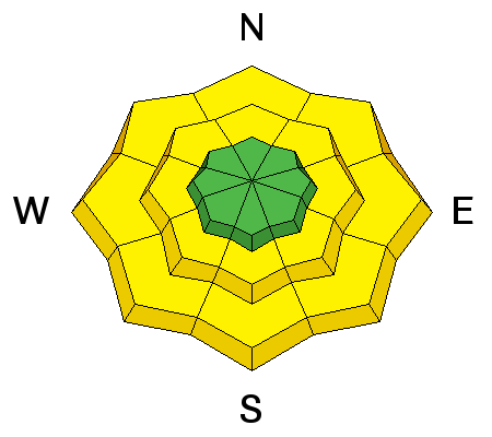
This past week's persistent slab avalanches were triggered on a layer of buried surface hoar or on a layer of small, faceted crystals buried 2-4 feet deep. This layer is widespread in the Ogden area mountains though there are some places where it was destroyed prior to the storm. The buried surface hoar is most dangerous where it was sheltered from the wind and buried intact. It might catch you off guard as you descend into sheltered, lower and mid-elevation slopes or gullies. Though observers near Ben Lomond noted its presence Thursday and were unable to get propagation while performing stabiity tests, this type of weak layer is deceptive and takes a while to strengthen. Because this weak layer can be coy, your best bet for finding it is to dig about 4 feet deep, perform stabilty tests like the ECT, and make sure it doesn't exist. Buried surface hoar does not behave like a typical weak layer so a lack of cracking, collapsing, or other obvious signs of instability does not mean slopes are stable. Tracks from other people are also not a guarantee of stability. If you are not interested in digging then the easy solution is to avoid being on, connected to, or underneath slopes steeper than 30 degrees. Left: Observed buried surface hoar near Rodeo Ridge was unreactive to stability tests Thursday. (pc:M. Henderson) Right: One of numerous avalanches failing on buried surface hoar or small facets on Monday in the Cutler Ridge area. (pc: B. Brandt) |
 |
weather Clear skies, moderate though gusty northerly winds, and temps rising to near freezing at 8500' today. High pressure builds throughout the region over the next few days. Storms passing by to the north of us will attempt to flatten the ridge, but we'll only see clouds and increased west to northwest winds through mid-week. Longer range models offer some hope for something next weekend. |
general announcements
|